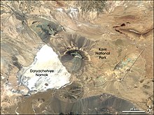
Kawir National Park
|
Kawir
|
|
| location | Iran |
| surface | 441,486 ha |
| WDPA ID | 703 |
| Geographical location | 34 ° 38 ' N , 52 ° 26' E |
| Setup date | 1982 |
| administration | Semnan Provincial Administration |
The Kawir National Park is a 4,000 square kilometer nature reserve on the western edge of the Kawir Desert (Dascht-e Kawir) , 120 km south of Tehran and 100 km east of Qom .
Wild goats , wild sheep , striped hyenas , wolves and gazelles as well as the rare Asian cheetah and the Persian leopard live in the desert and steppe landscape of the park . The vegetation of the desert consists mainly of succulents . On the edge of the national park is the salt lake Daryācheh-ye Namak , a salt marsh that is fed in the north by the Qom , which flows through the northern part of the national park and is one of the few rivers in Iran that permanently carry water.

