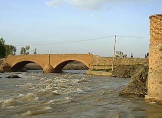
Hari Rud
|
Hari Rud Tedschen, Tejen |
||||
|
Minaret of Jam on Hari Rud |
||||
| Data | ||||
| location |
Ghor , Herat ( Afghanistan ), Iran , Turkmenistan |
|||
| River system | Hari Rud | |||
| Headwaters | in the mountains Koh-e Baba 34 ° 39 '0 " N , 66 ° 43' 0" O |
|||
| Source height | approx. 2750 m | |||
| Infiltration | in the Karakum Desert Coordinates: 37 ° 31 ′ 55 " N , 60 ° 22 ′ 17" E 37 ° 31 ′ 55 " N , 60 ° 22 ′ 17" E |
|||
| Mouth height | approx. 170 m | |||
| Height difference | approx. 2580 m | |||
| Bottom slope | approx. 2.3 ‰ | |||
| length | 1124 km (according to other sources 1150 km) | |||
| Catchment area | 70,600 km² | |||
| Discharge at the gauge Cagcaran A Eo : 6090 km² |
MQ 1961/1978 Mq 1961/1978 |
31.8 m³ / s 5.2 l / (s km²) |
||
| Discharge at the Robat-i-Akhond A Eo gauge: 21,630 km² |
MQ 1966/1978 Mq 1966/1978 |
47.5 m³ / s 2.2 l / (s km²) |
||
| Discharge at the Tir Pul A Eo gauge: 31,760 km² |
MQ 1969/1978 Mq 1969/1978 |
24.1 m³ / s 0.8 l / (s km²) |
||
| Left tributaries | Kashaf Rud ( ⊙ ) | |||
| Reservoirs flowed through |
Salma dam ( ⊙ ), Doosti dam ( ⊙ )
|
|||
| Big cities | Herat | |||
| Medium-sized cities | Sarakhs ( ⊙ ), Tejen ( ⊙ ) | |||
| Small towns | Serakhs , chaghcharan ( ⊙ ) | |||
|
||||
|
Hari Rud in Chaghcharan |
||||
|
Hari Rud in Herat |
||||
The Hari Rud ( Dari :هریرود; also Tedschen or Tejen ; Greek Ochos (in ancient times)) is a 1124 km long river in Afghanistan , Iran and Turkmenistan .
course
It rises in the center of Afghanistan in Koh-e Baba and flows westwards past the capital Chaghtscharan of the Afghan province of Ghor, which is 2280 m high, and past the minaret of Jam . In the province of Harat it is dammed by the Salma dam , whose hydropower plant is expected to deliver 42 MW from 2009. It then flows south past Herat . The river valley there is known for its high fertility and dense population. Later it forms the Iranian border with Afghanistan and Turkmenistan. About 5 km before the confluence of the Kaschaf Rud , the Hari Rud is dammed by the Doosti dam . The hydropower plant (16 MW) has been operated jointly by Iran and Turkmenistan since October 2005. The dam is also to be used for irrigation of the surrounding plain and for the water supply of Mashhad . The Hari Rud further flows through the border town of Zerah (Turkmenistan) / Sarakhs (Iran), crossing the Turkmenistan Karakum and the oasis city ends west Tedschen in a 60 km wide oasis in the desert Karakum .
Rud means something like "river" in Persian .
Hydrometry
Mean monthly discharge of the Hari Rud (in m³ / s) at the Robat-i-Akhond gauge
measured from 1966–1978

Web links
Individual evidence
- ^ Encyclopædia Britannica : Afghanistan Drainage
- ↑ geonames.org
- ↑ a b Article Hari Rud in the Great Soviet Encyclopedia (BSE) , 3rd edition 1969–1978 (Russian)
- ↑ a b c d Streamflow Characteristics at Streamgages in Northern Afghanistan and Selected Locations (PDF 5.6 MB) USGS.
- ↑ Afghan Energy Information Center (AEIC) Donor Projects (PDF)
- ^ Doosti Reservoir Dam


