Bam (Iran)
| Bam | ||
|---|---|---|
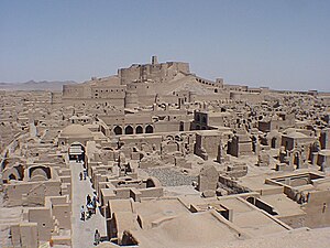
| Restored central part of the city from the city walls at the south gate, before the 2003 earthquake | ||
|
|
||
| Basic data | ||
| Country: |
|
|
| Province : | Kerman | |
| Coordinates : | 29 ° 6 ′ N , 58 ° 21 ′ E | |
| Height : | 1059 m | |
| Residents : | 77 296 (2013) | |
| Time zone : | UTC +3: 30 | |
Bam ( Persian بم) is a city in the province of Kerman in southeastern Iran with about 77,000 inhabitants (as of 2013).
geography
Bam is located in the central plateau of Eastern Iran, which consists mainly of steppe and sand desert . Date palms and citrus fruits thrive in the oases around the city and are irrigated by qanats .
history
The castle Arg-e Bam was probably v between the 6th and 4th centuries. Founded. The city, founded in an oasis by the Sassanids - if not earlier - was occupied by the Arabs in 642 . The Hazrat-e-Rasul Mosque was built around 650. Since the 7th century the city has been an important center of textile production and trade. As a fortified border post, the city was frequently attacked by Afghans , Baluchi and Sistani . In the 18th century the city was briefly conquered by the Afghans (1719 and 1721) and Lotf Ali Khan , the last Shah of Persia from the Zand dynasty , was defeated in old Bam in his last battle. The walled city was abandoned in the middle of the 19th century and today's Bam was founded two kilometers away. The historic city made of plastered adobe bricks served as a military camp until the beginning of the 20th century. Basically Bam's buildings date from the Safavid period (16th to 18th centuries).
earthquake
On December 26, 2003 at 1:56 UTC (5:26 local time) the citadel and much of the city of Bam were devastated by an earthquake . Its magnitude was 6.6 on the moment magnitude scale . 70 percent of the modern city of Bam was destroyed. Officially, 30,000 people died as a result of the earthquake, according to independent investigations there were over 43,000 dead and 30,000 injured. The United States sent rescue teams and medical supplies.
On July 21, 2004 the city of Bam was shaken again by an earthquake with a sky wave magnitude m b = 4.2. In this earthquake, prefabricated houses that had been built for survivors of the earthquake of December 26, 2003, were destroyed again.
The international community pledged Bam US $ 1.1 billion to rebuild.
findings
On the occasion of the evaluation of images of the earthquake catastrophe, undiscovered qanats (fresh water channels) as well as wall foundations, which dates back to around 2500 BC, were discovered. Back to BC, discovered.
Sandstorm
On March 16, 2007, the city was hit by a sandstorm traveling at 130 km / h without warning , in which 3 children were suffocated, 2 people were killed in traffic accidents and 14 others were injured.
World Heritage
The citadel was declared a World Heritage Site by UNESCO in 2004 and at the same time placed on the Red List of World Heritage in Danger. This is to ensure and support the reconstruction of the fortress, which was completely destroyed in the earthquake.
panorama
traffic
The city is on the Qom – Zahedan railway , the southern east-west rail link of Iran.
literature
- Eckart Ehlers: The city of Bam and its oasis surroundings / Central Iran: A contribution to the theory and practice of the relationships between rural areas and their small-town centers in the Orient. In: Geography. Volume 29, Issue 1, March 1975, pp. 38-52.
- Tammam Bakeer et al .: New ways for the seismic upgrading of world cultural heritage in earth building: The example of the citadel of Bam, Iran . Bautechnik November 2009, Vol. 86 (11), ISSN 0932-8351, pp. 695-703.
- Aude de Tocqueville: Atlas of the lost cities . Frederking & Thaler , Munich 2015, ISBN 978-3-95416-179-9 .
Web links
- Bam (Iran) . In: Ehsan Yarshater (Ed.): Encyclopædia Iranica (English, including references)
- Entry on the UNESCO World Heritage Center website ( English and French ).
- Photos of the citadel before the devastation of the earthquake
- Status report 2006 of the World Heritage Committee , p. 88ff (English, PDF, 742 kB)
- Comparative photos before and after the 2003 earthquake
Individual evidence
- ↑ Archived copy ( Memento of the original dated December 29, 2011 in the Internet Archive ) Info: The archive link was automatically inserted and not yet checked. Please check the original and archive link according to the instructions and then remove this notice.
- ↑ James Morris, Denis Wright: Persia . Atlantis, Zurich / Freiburg i. B. 1970, p. 118.
- ↑ Manuel Berberian: The 2003 Bam Urban Earthquake: A Predictable Seismotectonic Pattern Along the Western Margin of the Rigid Lut Block, South Eastern Iran. In: Earthquake Spectra. Volume 21, No. 1, 2005, pp. 35-99. ( Page no longer available , search in web archives )
- ↑ MJ Emami, AR Tavakoli, H. Alemzadeh, F. Abdinejad, G. Shahcheraghi, MA Erfani, K. Mozafarian, S. Solooki, S. Rezazadeh, A. Ensafdaran, H. Nouraie, FM Jaberi, M. Sharifian: Strategies in evaluation and management of Bam earthquake victims. In: Prehosp Disaster Med. 20 (5), September-October 2005, pp. 327-330, here: p. 328. PMID 16295170
- ↑ AP: "President Mohammad Khatami thanked the United States for aid" ; CNN: "more than 200 personnel and over 150,000 pounds of medical supplies"
- ↑ 5 Killed In Bam Sandstorm. Irib Persian News Page, archived from the original on September 27, 2007 ; Retrieved January 26, 2010 .


