Band-e Kaisar
Coordinates: 32 ° 3 ′ 13 ″ N , 48 ° 50 ′ 55 ″ E
| Band-e Kaisar | ||
|---|---|---|
| Remains of the bridge weir | ||
| use | Sassanid street Pasargadae - Ctesiphon | |
| Crossing of | Karun | |
| place | Shushar , Iran | |
| construction | Weir with arched bridge | |
| overall length | Approx. 500 m | |
| Number of openings | 40+ | |
| Clear width | 6.6-9 m | |
| Pillar strength | 5-6.4 m | |
| Flow profile | Approx. 1-1.8 to 1 | |
| construction time | Approx. AD 260–270 | |
| Status | Expired | |
| builder | Roman engineers and soldiers | |
| closure | 1885 | |
| location | ||
|
|
||
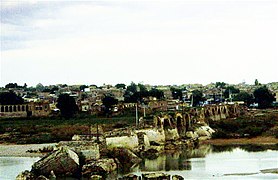
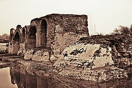
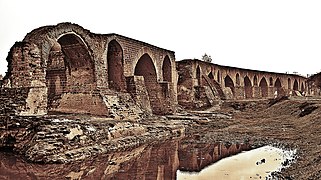
The Band-e Kaisar ( Persian بند قیصر, ' Caesar's Dam',پل قیصر Pol-e Kaisar , 'Caesar's Bridge'), the bridge of Valerian (پل والرین) or Schadrawan Bridge (پل شادروان) was an ancient bridge weir , a combination of arched bridge and weir , in Shushtar ( Iran ). The building, erected by Roman workers who had to work as Sassanid prisoners of war, was the first of its kind in Iran; Located deep in the Persian hinterland, it also represents the easternmost Roman bridge and Roman dam . The multi-purpose facility had a profound influence on Iranian civil engineering and made a significant contribution to the development of Sassanid hydraulic engineering.
The approximately 500 m long weir over the Karun , Iran's most water-rich river, was the core of the historical irrigation system of Shushar (سازههای آبی شوشتر), a large irrigation complex on which Shushar's agricultural productivity was based, and which was declared a World Heritage Site by UNESCO in 2009 . The important road from Pasargadae to the Sassanid capital, Ctesiphon, led along the arched superstructure . The bridge, which was often repaired in the Islamic era , remained in operation until the late 19th century.
History and meaning
According to Persian tradition, the Band-e Kaisar is named after the Roman emperor Valerian (253-260 AD), who was captured by Sassanids as a prisoner of war with his entire army at the Battle of Edessa (260). The surviving prisoners of this force, which before the battle could have comprised around 70,000 men including the Roman engineering corps , were dispatched by the Sassanid ruler Shapur I to work in Shushar, an important agricultural center in southwestern Iran. The Roman workers erected three different structures to irrigate the vast cultivated areas, a total of around 150,000 hectares : a canal called Ab-i Gargar and the two dams Band-e Kaisar and Band-e Mizan to divert the river water into the artificial watercourse.
The transmission of this story comes from the Muslim historians Tabari and Masudi in the 9th and 10th centuries. Although their report has unmistakably Roman-like features, the historical presence of the Romans in the area has also left etymological traces, such as in a nearby village called "Roumischgan" or the "Rumian", the name of a local tribe of the Lurs . In addition, the local tradition ascribes the emergence of certain folk customs and the introduction of certain crafts, such as the manufacture of brocade, to the Romans .
In the Sassanid era, the bridge weir at Shushar was part of the road connection between the two centers of power Pasargadae and Ctesiphon . It is believed that two other Sassanid dam bridges along the way, the Pa-i-Pol over the Karche and the bridge at Dezful over the Ab-i Diz, were also built at that time by Roman prisoners of war; This is supported by the fact that both structures were built from typical Roman masonry bonded with mortar , a construction technique that was completely unknown in local architecture.
The combination principle of the bridge dam, borrowed from the Roman model, was subsequently used by Iranian hydraulic engineers for almost all weirs and reached its climax and conclusion around 980 in the Band-e Amir near Shiraz, which still stands today .
More pictures
construction
The place Shushar is located on a rocky plateau above the Karun, the river with the most water in Iran. A first attempt by the Sassanids to build a dam to divert the river water into the city and onto its extensive agricultural areas failed. The irrigation plan tackled by the Roman workers consisted of three stages: First, the river above the dam construction site was diverted into the Ab-i Gargar Canal, which winds through the intensively cultivated orchards (Mianâb, called "paradise") until it joins the Karun again about 50 km south.
Then the Band-e Kaisar was built across the drained river bed; its meandering course is explained by the efforts of the builders to find a sufficiently firm foundation for the foundations of the building in the sandstone . Since the water flows incessantly over the top of the dam, the Band-e Kaisar is actually not a dam, but a weir . Estimates of the system's water level range from a few feet to 7-10 m; the actual water level is most likely 3–4 m, which was sufficiently high during the dry season for the water to drain off on both sides of the river. Despite its modest height, the weir had a fairly large wall thickness (9-10 m) in order to be able to support the arched arcade above it.
A 500 m long road ran over the weir, supported by at least forty arches. The pointed arches that characterize the appearance of the ruin today bear witness to the numerous reconstruction and repair work in Islamic times. The average clear arc of the Pol-e Kaisar varied between 6.6 and 9 m.
The rectangular pillars were protected on their upstream side by tapering breakwaters and had arched water passages in the upper area. With a width of 5 to 6.4 m, they narrowed the cross-section of the river by almost half, significantly more than in Roman bridges in the Reich , whose pillar strengths were usually a quarter of the total length of the bridge and did not exceed a third.
The outer cladding of the bridge piers and the foundation consists of sandstone blocks that were connected with mortar and iron staples. As with the Pa-i-pol bridge, the core was also filled with Roman concrete . On the river side, the river bed was probably laid out with large stone slabs as a precaution against undercutting the bridge foundations. An old Persian name for the dam, "Shadirwan", is derived from this paving.
As a third step - possibly later - the construction of the Band-e Mizans, a smaller dam, which was used to regulate the water flow into the Ab-i Gargar Canal, was built upstream. Overall, it took the Roman construction crews between three and seven years to build the ancient Shushar hydraulic engineering complex, depending on the estimate.
See also
Remarks
- ↑ Vogel 1987, p. 50
- ^ Römischer Bau: Schnitter 1978, p. 32; Kleiss 1983, p. 106; Hartung & Kuros 1987, p. 232; Hodge 1992, p. 85; O'Connor 1993, p. 130; Huff 2010; Kramers 2010; first of its kind: Smith 1971, pp. 56-61; Vogel 1987, p. 50.
- ↑ Schnitter 1978, p. 28, Fig. 7.
- ^ Influence on civil engineering: Huff 2010; on hydraulic engineering: Smith 1971, p. 60 f.
- ↑ length: Hodge 1992, p. 85; Hodge 2000, pp. 337 f .; agricultural productivity: O'Connor 1993, p. 130.
- ↑ UNESCO World Heritage: Shushtar Historical Hydraulic System , accessed May 1, 2010.
- ↑ a b c Hartung & Kuros 1987, p. 232.
- ↑ Use: Hodge 1992, p. 85; Hodge 2000, pp. 337 f .; Repair: Hartung & Kuros 1987, p. 246.
- ↑ Vogel 1987, p. 50; Engineer corps: Kleiss 1983, p. 106.
- ↑ Smith 1971, p. 58; Acres: O'Connor 1993, p. 130. The two dams are confused by Smith (1971) and Hodge (1992 & 2000). O'Connor (1993) also incorrectly locates the Band-e Kaisar at the Ab-i Gargar.
- ↑ a b c Kramers 2010.
- ^ Roman masonry: Hartung & Kuros 1987, pp. 232, 238, Fig. 13; 249; Iranian non-use: Chaumont 1964, p. 170, fn. 3.
- ↑ Smith 1971, pp. 60 f .; Vogel 1987, p. 50.
- ↑ a b Smith 1971, p. 57 f.
- ↑ Smith 1971, p. 58; Length: Hartung & Kuros 1987, p. 246; Orchards: UNESCO World Heritage: Shushtar Historical Hydraulic System, accessed May 1, 2010.
- ↑ Smith 1971, p. 57 ff .; Sandstone: Hartung & Kuros 1987, p. 232.
- ↑ Hodge 1992, p. 85; Hodge 2000, p. 337 f.
- ^ O'Connor 1993, p. 130.
- ↑ a b c d Hartung & Kuros 1987, p. 246
- ↑ 30-40 feet: Smith 1971, pp. 57 ff.
- ↑ Reconstructed arches: Smith 1971, pp. 112–113, plate 17; other repair measures: Hartung & Kuros 1987, p. 246.
- ^ O'Connor 1993, p. 164
- ↑ Smith 1971, p. 57 ff .; Hartung & Kuros 1987, p. 232.
- ↑ Smith 1971, p. 57 ff .; Stone slabs: Kramers 2010.
- ↑ Hartung & Kuros 1987, p. 247 f.
- ↑ Smith 1971, p. 57 ff.
literature
- Marie-Luise Chaumont: Les Sassanides et la christianisation de l'Empire iranien au IIIe siècle de notre ère . In: Revue de l'histoire des religions, Volume 165, No. 2, 1964, pp. 165-202 (170).
- Vittorio Galliazzo: I ponti romani . Vol. 1, Edizioni Canova, Treviso 1995, ISBN 88-85066-66-6 , pp. 89-90.
- Fritz Hartung, Gh. R. Kuros: Historical dams in Iran . In: Günther Garbrecht (Ed.): Historische Talsperren, Volume 1, Wittwer, Stuttgart 1987, pp. 221-274, ISBN 3-87919-145-X .
- A. Trevor Hodge: Roman Aqueducts & Water Supply . Duckworth, London 1992, p. 85, ISBN 0-7156-2194-7 (English).
- A. Trevor Hodge: Reservoirs and Dams . In: Örjan Wikander (Ed.): Handbook of Ancient Water Technology, Technology and Change in History, Volume 2, Brill, Leiden 2000, pp. 331–339 (337 f.), ISBN 90-04-11123-9 (English ).
- Dietrich Huff: Bridges . Pre-Islamic Bridges. In: Ehsan Yar-Shater, Columbia University. Center for Iranian Studies. (Ed.): Encyclopædia Iranica Online 2010 (as print at: Routledge, London / New York, NY 1985 ff. ISBN 0-7100-9099-4 , English).
- Wolfram Kleiss: Bridge constructions in Iran . In: Architectura, Vol. 13, 1983, pp. 105-112 (106) ISSN 0044-863X .
- JH Kramers: Shushtar . In: P. Bearman (ed.): Encyclopaedia of Islam , 2nd ed., Brill Online, Leiden 2010 (English).
- Colin O'Connor: Roman Bridges . Cambridge University Press, Cambridge, MA 1993, p. 130 (No. E42), ISBN 0-521-39326-4 (English).
- Niklaus Schnitter: Roman dams . In: Antike Welt , Volume 8, No. 2, Philipp von Zabern, Mainz 1978, pp. 25-32 (32) ISSN 0003-570X .
- Norman Smith: A History of Dams . Peter Davies, London 1971, pp. 56-61, ISBN 0-432-15090-0 (English).
- Alexius Vogel: The historical development of the weight wall . In: Günther Garbrecht (Ed.): Historische Talsperren, Volume 1, Wittwer, Stuttgart 1987, pp. 47–56 (50), ISBN 3-87919-145-X .
Web links
- Jonah Lendering: Shushtar . In: Livius.org (English)
- Entry on the UNESCO World Heritage Center website ( English and French ).


