Maymand
| Maymand | ||
|---|---|---|
|
|
||
| Basic data | ||
| Country: |
|
|
| Province : | Kerman | |
| Coordinates : | 30 ° 13 ′ N , 55 ° 22 ′ E | |
| Height : | 2227 m | |
| Surface: | approx. 400 m² | |
| Residents : | approx. 140 () | |
| Time zone : | UTC +3: 30 | |
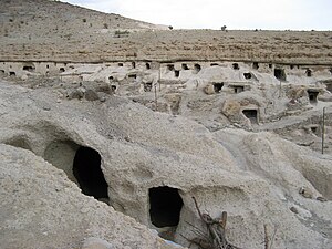
Maymand ( Persian میمند) is a historic cave village dug into the rock in the province of Kerman in Iran , 36 km from the city of Shahr-e Babak .
The village is in an arid climate zone and is irrigated by qanats . Pistachios and wild almond trees grow in the semi-arid landscape . The fauna of the Maymand Plain includes desert animals such as snakes , crocodiles , hedgehogs and turtles . In the mountains you can find deer , leopards , wolves , foxes , zebras , ibex and different types of birds.
The approximately 140 inhabitants of the village are semi-nomads and live from agriculture, cattle breeding and their craft. The shepherds ' summer accommodation includes so-called Kapars and Gambehs , round stone houses with conical wooden roofs. The other cave houses are terraced in four to five steps. They consist of several 16–20 m² rooms with a stove in the middle. Parts of the village serve as a museum and are open to the public.
The local dialect still contains many words from Middle Persian today .
The cave village, which has been inhabited for 2000-3000 years, was awarded the Greek Melina Mercouri Prize by UNESCO in 2005 in recognition of its cultural landscape . The Maymand cultural landscape has been a World Heritage Site since 2015.
See also
- Kandovan , rock village in the province of East Azerbaijan , near Tabriz
Web links
- Entry on the UNESCO World Heritage Center website ( English and French ).
- Photos on www.pbase.com
- The village of Maymand. The music by Karunesh (Inshallah) on YouTube
Individual evidence
- ↑ a b Maymand on itto.com
- ↑ Article on the Unesco Prize 2005
- ↑ Article on payvand.com
- ↑ Article on the Unesco Prize 2005 and article on payvand.com
- ↑ see article on the UNESCO award and on payvand.com


