Pontic Mountains
| Pontic Mountains | ||
|---|---|---|
| Highest peak | Kaçkar Dağı ( 3932 m ) | |
| location | NO- Turkey | |
|
|
||
| Coordinates | 40 ° 50 ′ N , 41 ° 10 ′ E | |
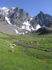
The Pontic Mountains or Pontic Alps ( Turkish Kaçkar Dağları , also Pontus Mountains or North Anatolian Edge Mountains ) are a series of mountain ranges in northern Turkey that extend about 1000 km along the Black Sea coast of Asia Minor . They belong to the relatively young Alpine folds of the Alps, which run from the Pyrenees and Alps to the Himalayas, and reach summit heights of up to 3,932 meters. The name is derived from the ancient Greek name Pontos for the landscape on the coast of the Black Sea (Pontos Euxinos) , which was also transferred to the Roman and later Byzantine province of Pontus, which existed until 1143.
Geography and agriculture

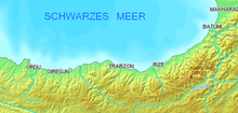
The Pontic Mountains rise just south of the Black Sea after only a narrow coastal strip. Its individual mountain ranges are on average 300 km long, mostly run in an east-west direction and reach about 100 to 200 km inland. In the western and central parts, the mountain ranges are lower and only reach heights of up to 2500 m north of Ankara , while in the east many peaks are over 3000 m high and in the Eastern Pontic Mountains ( Doğu Karadeniz Dağları ) represent a striking coastal mountain range. The highest point, the Kaçkar Dağı (3932 m) is close to the border with Georgia . There, near the Georgian port city of Batumi , the Pontic Mountains run out, but continue to the southwest in the Ararat and Lesser Caucasus .

Most of the rivers in the upper reaches are bound to the east-west direction of the mountain ranges, but they break through to the Black Sea in narrow transverse valleys or gorges. The settlement centers are located on the narrow coastal strip near these estuaries: in the west Kozlu and Zonguldak , Sinop , Bafra and Samsun , in the east especially Altınordu , Trabzon and Rize . The Kızılırmak (the ancient Halys ) is an exception in the general course of the river . This river, which is 1400 km long in Turkey, originates only 100 km south of the Black Sea (near Sivas ), but flows into the Central Anatolian highlands and only turns after a wide semicircle back to the east and north until, after a few breakthrough valleys near Bafra, it empties a wide peninsula into the sea. In this and some other fertile alluvial plains , the few traffic routes from the interior reach the coast.
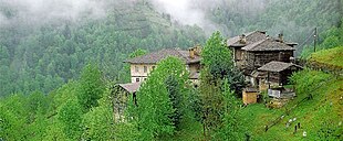
The steep northern roofing of the mountain ranges is densely forested due to the frequent rainfall ( incline rain ) and partly good agricultural land. Mainly hazelnuts ( Pontic hazel ), tea , tobacco , olives and, more recently, cherries and citrus fruits are cultivated here. The centers of Turkish rice cultivation are in the eastern lowlands . Areas that are not suitable for cultivation because of their steepness or the unsafe soil ( sliding slopes ) are partly densely overgrown with rhododendrons . The higher regions are also used as pasture and alpine pastures . The forest is mainly a Nordmann fir - Orient beech - mixed forest . The tree line is between 2000 and 2300 meters. Year-round settlement also extends to these heights on the north side of the mountains.
To the south, towards the Anatolian highlands , there is no forest because of the low rainfall; there the extremely sparsely populated landscape is largely montane steppe character . Willows and poplars only grow along the rivers and in basin landscapes ; there are isolated stands of oak and black pine . Because of the sparse population, flora and fauna are still very species-rich.
Geology and rivers
Asia Minor ( Anatolia ) is framed on three sides by long mountain ranges, which is why the Pontic Mountains are also called the North Anatolian Edge Mountains in geomorphology . Its southern counterpart is the Taurus Mountains bordering the Mediterranean . Geologically, both belong to the extensive system of the relatively young Alpid mountain formation , which runs from the Pyrenees over the Alps and Carpathians, the Balkans, Caucasus and Iran to the Hindu Kush and Himalayas. The tectonic movements of the earth's crust, which continue to this day , lead to strong earthquakes .
In the western part of the Pontus Mountains, in addition to the Alpid folds, there are still larger remains of the geological old Variscan orogeny . While these rump surfaces and ridges are higher than 2000 meters in only a few places, the Eastern Pontic Mountains (Doğu Karadeniz Dağları) rise in numerous peaks far over 3000 meters and in Kaçkar Dagi even to 3937 meters.
In the upper reaches, all major rivers follow the east-west course given by the mountain ranges. To get to the Black Sea, however, they have to make their way to the coast in deep cross valleys. The most important river in Turkey, the Kızılırmak ( Halys ), northeast of Ankara even forms a regular zigzag pattern of several picturesque breakthrough valleys . Like the Yeşilırmak , its delta estuary lies in front of the central part of the mountain range far into the sea, while the third peninsula of the region (near Sinope ) comes from a comparatively small but steep body of water.
The most important rivers in the western part are the Yenice (breakthrough valley at Karabük ) and Gökırmak , while the eastern part is dominated by the extensive, tectonic long valley furrow of the Kelkit and Çoruh . The Karasu also rises a little to the south - near Erzurum - but then flows south to the Euphrates . The Kura takes the opposite course, which has its source in the northeastern province of Kars and initially flows east to Georgia and later to the Caspian Sea . Despite its peripheral location, the Pontic Mountains represent the watershed between a total of three seas, which is related to its geological history.
According to research results of the TU Berlin , the genesis of various deposits and the petrology of some magmatites indicate that the Eastern Pontic Mountains (northeast Turkey) represent a (paleo) island arc . According to this, the neighboring anatolids to the south were formed in the pre-depth zone of this volcanic arc . According to the theory of plate tectonics , the Black Sea is then to be regarded as an active marginal basin north of the island arc and its continental crust has been converted into oceanic crust in the central area.
Among the Eastern Pontic deposits, the non-ferrous metals coupled with the acidic volcanic rocks are to be mentioned, while the porphyry copper ores are likely to be economically less productive. The extensive hard coal deposits near Zonguldak in the western Pontic Mountains are of great importance .
Numerous industries are located here - in addition to coal, the textile industry and iron processing, among others . In the other mountain regions , the processing of local products such as wood, meat and the above-mentioned agricultural products primarily play an economic role.


