Alluvial plain


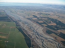
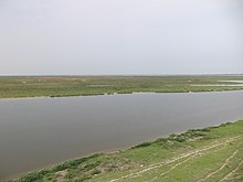
A flood plain is a mostly flat terrain in low gelegenem ground (see FIG. → Plain ) formed by the deposition of sediments over a period of hundreds to thousands of years by one or more flows piled is. At its upper end it is usually delimited from a highland by alluvial fans , while at the lower end it merges into the mouth of the river (e.g. a delta ). The (sub) recent sediments of an alluvial plain are also known as alluvial soils . The flood plain consists of the channel bed, which usually carries water permanently and moves over the flood plain over time, and the actual floodplain, which is flooded at regular intervals (one to several times a year) when the water flow of the River exceeds the absorption capacity of the river bed (river flood ).
In this sense, alluvial plains are relatively extensive sedimentation areas outside of the highlands (see → lowlands ). Not infrequently, however, small-scale sedimentation areas on rivers in the highlands, for example in valley widenings, are referred to as "alluvial plains", although erosion dominates there in geological time periods .
Emergence
While the higher ground of the source regions of flowing waters is gradually deepened by weathering and erosion , the material discharged there with the draining water reaches the lowlands via smaller channels as sediment load, where the channels combine to form a larger river, which ultimately either becomes one even larger river or flows into the sea. Since the slope and the difference in height to the erosion base are small in the lower terrain , the flow speed of the water is also lower there than in the highlands and, in contrast to the highlands, there is in fact no more deep erosion, but only side erosion. Therefore, a river in the lowlands deposits a large part of the sand particles of its sediment load in the channel bed and around ( English Channel Deposits ), whereby it usually does not flow in a straight line, but forms meanders . During floods, the river overflows its banks and large parts of the plain can take on a more still water- like character for a few days or weeks . Then the finest-grained fractions of the sediment load ( silt and clay ) z. Partly deposited far outside the actual channel bed (English Overbank Deposits 'over-the-bank deposits'). In such events, the main part of the sediment load is deposited in the area of the banks, so that natural river dikes (English levees ) are raised there. In this way a river can raise its level above the level of the surrounding floodplain, which also leads to a gradual backfill of the actual channel bed above its original level. If such a dike breaks during flooding, typical sediment compartments form at the breakpoints, which are known as Crevasse Splays and are included in the Overbank Deposits. Since water always tries to follow the steepest gradient, such dike breaches can lead to the fact that the river no longer returns to its old bed at this point after the flood, but instead takes a slightly different path. The higher lying areas of the old channel bed, which are mostly adjacent to the newly formed channel, are over the course of time by the side erosion (impact slope erosion) of the river or, if no stabilizing vegetation can establish on these areas, by heavy rain and wind at least partially removed again. The interplay of partly large-scale deposits and side erosion forms the mostly extremely poorly relief alluvial plain over relatively short geological periods.
In the case of long-lasting, permanent tectonic subsidence (subsidence) of the crustal area in which the alluvial plain is located, as is the case, for example, with rift breaks or in the foreland of young fold mountain ranges , powerful sequences can occur in longer geological periods (hundreds of thousands to several million years) Alluvial sediments accumulate. Are geological evidence of this example, the mittelpermischen to Upper Triassic sedimentary rocks of the Karoo Basin in South Africa, under Triassic sedimentary rocks of red sandstone in Central Europe or the Middle Triassic to Lower Jurassic sedimentary rocks of the Newark Supergroup in eastern North America.
meaning
The fertile fine-grained sediments and the resulting alluvial soils of the alluvial plains have been used by people for the cultivation of food crops for thousands of years. In fact, all of the early great civilizations in human history were located in the floodplains of large rivers.
In modern civilizations, most of the floodplains have been converted into cultivated landscapes and the rivers have often been artificially dammed. In such a setting, the regularly occurring river floods are more of a threat to these often densely populated areas. Especially in developing and emerging countries, river floods regularly claim hundreds or even thousands of lives, while in industrialized countries they cause damage amounting to at least many millions of euros.
Examples of typical recent flood plains
- North China Plain
- Po Valley in Italy
- Stromland on the middle and lower reaches of the Ganges
- Mesopotamia in Iraq
- Middle and lower reaches of the Nile in Sudan and Egypt
literature
- Frank Ahnert: Introduction to Geomorphology. 4th edition, 2009, ISBN 978-3-8001-2907-2 (Ulmer) / ISBN 978-3-8252-8103-8 (UTB)
- Hans Füchtbauer: Sedimentary storage rooms . P. 865–960 in: Hans Füchtbauer (Ed.): Sediment-Petrologie Part II: Sediments and sedimentary rocks. 4th edition. Schweizerbart, Stuttgart 1988, p. 871 ff.
Web links
- Alluvial plain in the spectrum Online encyclopedia of geography
