
River delta

A river delta , also delta estuary or estuary delta , is a river estuary into a lake or a sea , which is characterized by an approximately triangular plan and the fork of the main stream into several estuary arms.
Word origin
The word Delta originally goes back to the letter Daleth ( ![]() , presumably "door") of the Phoenician script . Around the middle of the ninth century BC This was taken over as Delta (Δέλτα) in the Greek alphabet . The Greek historian Herodotus used Delta fourteen times in his histories as a proper geographical name for the Nile Delta , describing the extent of the Nile Delta, but drawing no explicit parallel to the shape of the letter. As Herodotus mentions, the word delta for the mouth of the Nile was already known to the Greeks ( Ionians ).
, presumably "door") of the Phoenician script . Around the middle of the ninth century BC This was taken over as Delta (Δέλτα) in the Greek alphabet . The Greek historian Herodotus used Delta fourteen times in his histories as a proper geographical name for the Nile Delta , describing the extent of the Nile Delta, but drawing no explicit parallel to the shape of the letter. As Herodotus mentions, the word delta for the mouth of the Nile was already known to the Greeks ( Ionians ).
Only later did the character of the word change and change from a proper name to a technical term for river deltas, now also explicitly with regard to the triangular shape of the letter. The generalization becomes clear in Arrian's historical work Alexandri Anabasis about Alexander the Great at the beginning of the second century AD, where the mouths of the Indus , Danube and Nile are compared and referred to as deltas.
Emergence

A delta estuary occurs when the river's flow velocity is slowed down to practically zero in the area of the river's estuary , so that most of the material that has been carried along until then is deposited as sediment (see → Hjulström diagram ). At a largely constant sea level , the river shifts its mouth over centuries and millennia by continuously unloading its sediment load further and further out to sea, and the former mouth area silts up . His own deposits increasingly block his way to the sea, so that the main stream forks several times. In this way, the characteristic delta shape is created, as can be seen in maps and satellite images of many river mouths. A prerequisite for the formation of delta estuaries is a low tidal range in the estuary area, as otherwise tidal currents prevent the undisturbed filling of an estuary fan.
The mouth fan can be roughly divided into three areas in cross section, each representing a specific sedimentation phase. At the bottom lie the flat, very fine-grained base layers ( bottomset ) that were originally sedimented in the deep water in front of the delta (hence also called the prodelta ). This is followed by the steeply falling submarine pre- fill layers of the delta ( foreset or submerged delta ) and finally the fluvial sedimented and therefore horizontally stored roof layers of the silting phase ( called topset or emerged delta ).
With a relatively rapid rise in sea level (a few meters per 100 years), it is possible that river deltas will be completely washed over by the sea and covered with marine sediments. Such fossil deltas are known from seismic explorations of the continental shelves . They can provide information about the sea level and the course of the coasts and rivers during the last ice age .
Delta species
Some river deltas
- Amazonas , largest river delta in the world ( estuary )
- Danube Delta , 5,000 km², the second largest river delta in Europe
- Ebro Delta , 400 km²
- Ganges delta , 80,000 km²
- Indus , 8,000 km²
- Irrawaddy , 30,000 km²
- Lena Delta , 32,000 km²
- Mekong Delta , 70,000 km²
- Mississippi River Delta , 36,000 km²
- Niger Delta , 70,000 km², also forms an inland delta ( Massina ) in its middle course
- Nile Delta , 24,000 km²
- Ogowe , 4,800 km²
- Orinoco , 24,000 km²
- Pearl River Delta , 39.380 km², is home to the largest metropolitan area in the world (Guangzhou)
- Po , 380 km²
- Rhine-Maas Delta
- Rhone , over 750 km²
- Song Hong , 15,000 km²
- Ural Delta
- Vistula , 1,500 km²
- Volga Delta , 27,224 km², largest river delta in Europe
- Yukon-Kuskokwim Delta , 70,000 km²
Alien examples
- Mars : Paleo Delta in the Eberswalde crater , 143 km²
- Saturn's moon Titan : Wave-dominated river delta on the west bank of the methane - ethane lake Ontario Lacus , approx. 500 km²
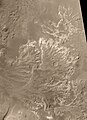
A paleo river delta in the Eberswalde crater on Mars
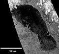
Radar scan of the methane - ethane lake Ontario Lacus on Saturn's moon Titan. A wave-dominated delta can be seen on its western bank .


See also
literature
- Frank Ahnert: Introduction to Geomorphology. 4th edition, 2009, ISBN 978-3-8001-2907-2 (Ulmer) / ISBN 978-3-8252-8103-8 (UTB), chap. 17.2. Deltas
Web links
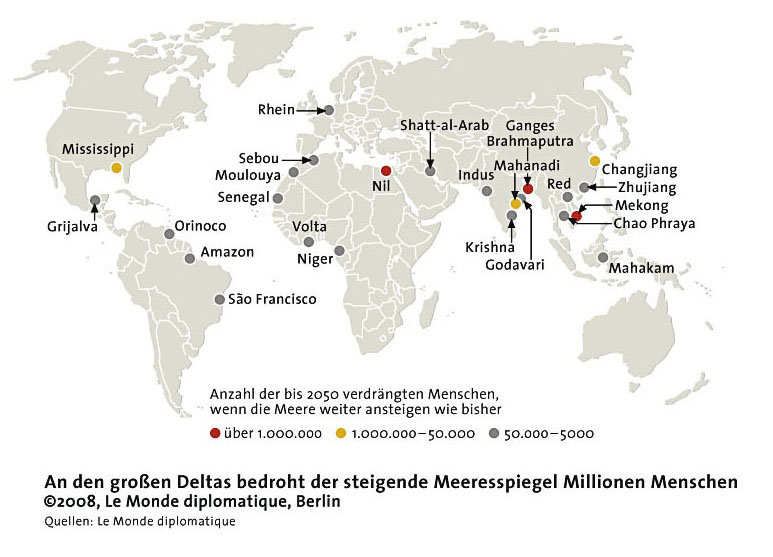
- Map with large deltas monde-diplomatique.de
Individual evidence
- ^ Francis Celoria: Delta as a Geographical Concept in Greek Literature. In: Isis, vol. 57, No. 3, Fall 1966, pp. 385-388.
- ↑ Major Agglomerations of the World - Population Statistics and Maps. Retrieved November 6, 2017 (American English).