Pontos (region)
Pontus ( ancient Greek Πόντος Sea ' , Latin Pontus is) a historic landscape on the Asia Minor coast of the Black Sea ( Πόντος Εὔξεινος Pontos Euxeinos ) in northeastern Anatolia in modern Turkey.
Surname
The name is derived from the Greek name of the Black Sea. As a designation for the coastal land in front of Cappadocia , phrases like Kappadokía hē perí ton Eúxeinon (that is, "the part of Cappdocia facing the sea") or hē pros tōi Póntōi Kappadokía were used, but Pontos is also used by Strabo alone. The earliest evidence of Pontus as the name of the region can be found in Xenophon .
location
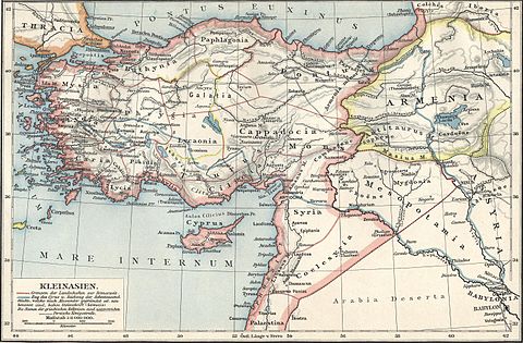
In the course of history , Pontos has referred to areas of greatly varying expansion as a political entity . The Pontic heartland includes the coastal region between the Black Sea up to and including the Pontic Mountains and parts of the area behind. In ancient geography it is bounded by Paphlagonia in the west, with the Halys often being considered a border river, in the south by Galatia , Cappadocia and Armenia minor and in the east by Colchis and Armenia with the Phasis as the border river.
An important river was the Lykos (today the Kelkit Çayı ), which ran westwards between the mountains Paryadres in the north and Ophlimos and Lithros in the south , whose narrow valley widened to the fertile plain of Phanaroia before it reached Eupatoria in the Iris (today Yeşilırmak ) ended. Another important tributary of the Iris was the Skylax (now Çekerek Irmağı ).
The landscape got its special character from the meeting of autochthonous inhabitants of the inland, who were culturally oriented more towards Persia, and the Greek colonies on the coast. These included Amisus , Kotyora , Pharnakeia and Trapezus .
history
Kingdom of Pontus
The area originally belonged to the Persian satrapy of Cappadocia. After the collapse of the Persian Empire under the attack of Alexander , a power vacuum developed in which a dynasty originally from Kios on the Propontis was able to expand its influence. 281 BC Chr. Took Mithridates I. Ktistes the royal title and won 279 v. BC with the port city of Amastris an access to the sea. Under his sons, the territory expanded, also through a dynastic connection with the Seleucids . The expansion only came to a standstill under Pharnakes I in the Pontic War (182-179). His descendant Mithridates VI. succeeded in the 1st century BC Finally, to lead the empire to its greatest expansion and then to its greatest defeat. In the three Mithridatic Wars , Pontus was finally defeated by Rome and made a client state .
The western part of Pontus was built in 63 BC. It was incorporated into the newly created province of Bithynia et Pontus by Gnaeus Pompeius Magnus , the eastern part continued to exist as a dependent kingdom under various dynasts, while Pharnakes II, the son of Mithridates VI., Tried unsuccessfully to extend the western part of the Bosporan Empire from To recapture his father's empire. 37 BC In BC Mark Antony established Polemon I , a citizen from Laodikeia on Lykos , as ruler in Pontus.
Roman province
After the Polemons dynasty died out in AD 64, their territory was annexed by Nero as Pontus Polemoniacus to the province of Galatia . Previously there were 3/2. v. The area of Amaseia and the Karanitis as Pontus Galatica and in 34/35 AD the priestly state of Komana Pontika was also added to Galatia. Due to his marriage to Pythodoris von Pontos, Archelaos of Cappadocia fell to their Pontic territory, the area was therefore briefly referred to as Pontus Cappadocius .
Byzantine Diocese
As part of the imperial reforms of Diocletian at the end of the 3rd century, the Dioecesis Pontica was set up under a vicarius residing in Amaseia , whose territory included the entire south coast of the Black Sea and large parts of Anatolia. The military commander of the area was the Dux Ponti et Armeniae . The dioecesis was divided into the following provinciae :
- Bithynia
- Paphlagonia, later divided into Paphlagonia and Honorias
- Diospontus , later Helenopontus (capital Amaseia)
- Cappadocia , later divided into Cappadocia I and Cappadocia II
- Pontus Polemoniacus (main town Neokaisareia )
- Armenia minor , later divided into Armenia I and Armenia II
- Galatia, later divided into Galatia and Galatia salutaria
- Pisidia , later split into Pisidia and Lycaonia
In the 7th century the dioecesis was dissolved and the area was divided between the subjects of Armeniakon and Opsikion .
Empire of Trebizond
Pontus under the Ottomans
Republic of Pontus
literature
- Anthony Bryer , Richard Winfield: The Byzantine Monuments and Topography of the Pontos . Dumbarton Oaks, Washington DC 1985.
- Christian Marek: Pontus et Bithynia. The Roman provinces in northern Asia Minor. Philipp von Zabern, Mainz 2003.
- Eckart Olshausen : Pontos. In: Paulys Realencyclopadie der classischen Antiquity Science (RE). Supplementary Volume XV, Stuttgart 1978, Sp. 396-442.
- Eckart Olshausen, Johannes Niehoff : Pontos 2. In: The New Pauly (DNP). Volume 10, Metzler, Stuttgart 2001, ISBN 3-476-01480-0 , Sp. 142-144.
- Leonhard Schmitz : Pontus . In: William Smith : Dictionary of Greek and Roman Geography. London 1854.
- Karl Strobel , Georgios Makris : Bithynia et Pontus. In: The New Pauly (DNP). Volume 2, Metzler, Stuttgart 1997, ISBN 3-476-01472-X , Sp. 698-702.


