Rioni
|
Rioni ancient name: Phasis |
||
|
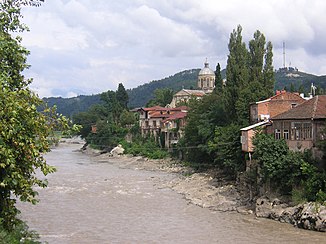
The Rioni in Kutaisi |
||
| Data | ||
| location | Georgia | |
| River system | Rioni | |
| Headwaters | South flank of the Greater Caucasus 42 ° 52 ′ 6 ″ N , 43 ° 21 ′ 52 ″ E |
|
| muzzle | in the Black Sea north of Poti Coordinates: 42 ° 11 ′ 3 ″ N , 41 ° 38 ′ 10 ″ E 42 ° 11 ′ 3 ″ N , 41 ° 38 ′ 10 ″ E |
|
| Mouth height |
0 m
|
|
| length | 327 km | |
| Catchment area | 13,400 km² | |
| Outflow at the level at the mouth |
MQ |
405 m³ / s |
| Left tributaries | Dschedschora , Chaniszqali , Qwirila | |
| Right tributaries | Lajanura , Gubiszqali , Zcheniszqali , Tekhuri | |
| Reservoirs flowed through | Wartikhe reservoir | |
| Big cities | Kutaisi | |
| Medium-sized cities | Samtredia , Poti | |
| Small towns | Oni , Ambrolauri | |
| Navigable | 95 km | |
|
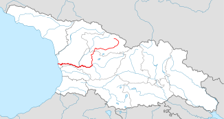
Course of the Rioni in Georgia |
||
|
The upper Rioni in Ratscha |
||
|
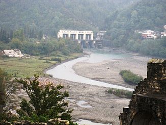
Hydroelectric power station on the Rioni near Kutaisi |
||
|
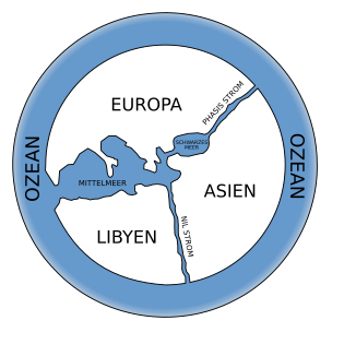
World map from Anaximander with the Rioni as phasis |
||
|
Map of the estuary delta |
||
The Rioni ( Georgian რიონი ) is the third longest river in Georgia .
History and usage
The river is 327 kilometers long and has its source on the southwest slope of the Greater Caucasus in Svaneti . It initially flows through the Ratscha-Letschchumi region and Lower Vanetia, mostly as a wildly roaring mountain river, reaches the lowlands in Imereti and crosses the Colchian Plain on the border between Mingrelia and Guria in a westerly direction to the Black Sea . At its mouth near Poti , it forms a swampy river delta. The banks of the Rioni are characterized by lush vegetation and forest wealth.
The upper and middle reaches are used to generate electricity: The Warsaw hydropower plant cascade is the third largest electricity producer in Georgia with an output of 184 megawatts (MW). The government plans to build further hydropower plants on the Rioni: Namachwani (250 MW) and Schoneti (100 MW). At the lower reaches of the lowlands, the river was dammed, straightened and supplemented with an extensive canal system in Soviet times to irrigate the subtropical agriculture.
history
The Greeks called the river Phasis (Φάσις). Already Hesiod mentions him in the Theogony . A detailed description can also be found in the Corpus Hippocraticum (About the air, the waters and the localities), later also in Apollonios of Rhodes , Virgil and Aelius Aristides . Hecataeus of Miletus assumed that the Phasis linked the Black and Caspian Seas .
The river was already in the 7th century BC. Of great importance. It connected the Greek port city of Phasis (today Poti) at the mouth of the river with Kutaia (today Kutaisi ) on the middle course of the river. Ships carried grain, metal, wine, olives and ceramics.
The vast hinterland of the city of Poti, inaccessible due to extensive swamps, has been notorious since ancient times as a region at risk of epidemics (malaria, malaria). It was not until the 20th century that projects for drainage were implemented at great expense.
literature
- D. Braund: Georgia in Antiquity: A History of Colchis and Transcaucasian Iberia 550 BC – AD 562 . Oxford 1994.
Web links
Individual evidence
- ↑ a b c Article Rioni in the Great Soviet Encyclopedia (BSE) , 3rd edition 1969–1978 (Russian)
- ↑ Hesiod, Theogony 337-340
- ↑ http://classics.mit.edu/Hippocrates/airwatpl.15.15.html Airs, Waters, and Places 15. 20ff.
- ↑ Argonautika 2.1261
- ^ Georgica 4,367
- ^ Ad Romam 82
- ^ Tessa Hofmann : Armenia and Georgia . In: Express travel guide . Mundo-Verlag, Leer 1990, ISBN 3-87322-001-6 , Poti, p. 339 .


