Çoruh
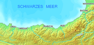
The Çoruh ( Turkish ) or Tschorochi ( Georgian - ჭოროხი) is a 376 km long river that has its source at Mescit Dağı ( 3225 m ) in the Erzurum province in northeastern Turkey.
The river flows west to İspir and Bayburt . Then it makes a bow to the east and runs through the province of Artvin to Georgia, where it flows south of Batumi into the Black Sea . An important tributary is the Berta Çayı , which flows into the Çoruh at Artvin.
history
Miroj Salvini locates the Iron Age Kingdom of Diaueḫe in the upper Çoruh Valley, but there is no archaeological evidence for this.
The ancient name of the Çoruh is Acampsis . According to Diakonov and Kaškai, the Çoruh corresponds to the ancient Τάοχοι / Τάοι. Prokopios of Caesarea knows the Çoruh as boas. However, he confuses it in the area of the mouth with the Phasis , which is 70 km further north. He also reports that the Çoruh is navigable from Artvin (water-rich tributary Merehevi Suyu (today's name: Berta Çayı )).
Flora and fauna
Many rare plants and birds live in the river valley. It is to be declared a nature reserve.
Dams
The valley is threatened by plans to build dams:
| dam | phase |
|---|---|
| Muratlı Dam | in operation |
| Borçka dam | in operation |
| Deriner dam | in operation |
| Artvin dam | under construction |
| Yusufeli dam | under construction |
| Arkun dam | under construction |
| Aksu dam | under construction |
| Güllübağ dam | in operation |
| İspir Dam | planned |
| Laleli dam | under construction |
Web links
- European Rivers Network
- ECA Watch (PDF file; 468 kB)
- Friends of the Earth (PDF file)
Individual evidence
- ↑ a b c Article Çoruh in the Great Soviet Encyclopedia (BSE) , 3rd edition 1969–1978 (Russian)
- ↑ DSI
- ^ M. Salvini: The historical geography of the Sevan Region in the Urartian period. In: Raffaele Biscione et al. (Ed.): The North-Eastern Frontier Urartians and non-Urartians in the Sevan Lake Basin. Volume I: The Southern shores. (= Documenta Asiana. 7) Rome 2002, ISBN 88-87345-06-6 , p. 38.
- ↑ Arrian
- ↑ Igor' Mikhailovich Diakonov, SM Kashkai: Geographical names gemäß to Urartian texts. (= Répertoire géographique des textes cunéiformes. 9). Reichert, Wiesbaden 1981, p. 26
- ^ Robert W. Edwards: The Vale of Kola: A Final Preliminary Report on the Marchlands of Northeast Turkey. (= Dumbarton Oaks Papers. 42). 1988.
- ↑ N. Ozhatay, A. Byfield, S. Atay: Important Plant Areas of Turkey. 122 key Turkish botanical sites. for WWF Turkey, Istanbul 2005.
- ↑ Conservation International Biodiversity Hotspots ( Memento from February 22, 2007 in the Internet Archive )
- ^ G. Magnin, M. Yarar: Important Bird Area in Turkey. Dogal Hayati Koruma Dernegi, 1989.
- ↑ G. Eken, M. Bozdogan, S. I˙sfendiyaroglu, DT Kılıç, Y. Lise (eds.): Key biodiversity areas in Turkey. Doga Dernegi, Ankara 2006.
- ↑ ENCON 2006, 'Yusufeli Dam and Hydroelectric Power Project Environmental Impact Assessment', Ankara, Turkey. ( Memento from August 28, 2009 in the Internet Archive )


