Oltu Çayı
|
Oltu Çayı ancient names: Glaukos, Glaucus |
||
|
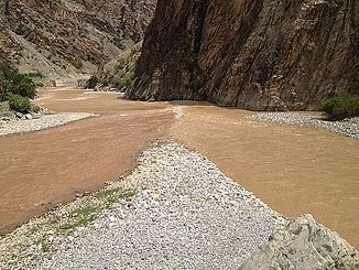
Mouth of the Oltu Çayı (right) into the Çoruh (left) |
||
| Data | ||
| location | Artvin , Erzurum ( Turkey ) | |
| River system | Çoruh | |
| Drain over | Çoruh → Black Sea | |
| source | southeast of Tortum 40 ° 12 ′ 57 " N , 41 ° 35 ′ 35" E |
|
| Source height | approx. 2650 m | |
| muzzle |
Çoruh coordinates: 40 ° 48 ′ 42 " N , 41 ° 38 ′ 35" E 40 ° 48 ′ 42 " N , 41 ° 38 ′ 35" E
|
|
| length | 144 km | |
| Left tributaries | Tortum Çayı | |
| Right tributaries | Penek Çayı , Alabalık Çayı | |
| Small towns | Oltu | |
| Communities | Yolboyu , Tuzlaköy , Coşkunlar , Köprübaşı , Taşlıköy , Ayvalı | |
The Oltu Çayı is a right tributary of the Çoruh in eastern Turkey .
The Oltu Çayı was called Glaukos (Latinized Glaucus ) in ancient times . It rises in the mountains southeast of the city of Tortum . From there it flows in an easterly direction. He passes the Hamidiye settlement . Later it turns north-northeast in a wider valley. The overland road D955 follows the course of the river. The Oltu Çayı flows through the city of Oltu . The villages of Yolboyu and Tuzlaköy follow . The Penek Çayı flows into the river on the right. Then the Oltu Çayı cuts through the mountains. He is gradually turning west. At Köprübaşı the Alabalık Çayı flows into the river from the north. The places Taşlıköy and Ayvalı follow . 8 km above the mouth, the Tortum Çayı meets the river from the south. The Oltu Çayı finally flows into the Çoruh 10 km east of the city of Yusufeli . The Oltu Çayı has a length of 144 km.
