Tortum Çayı
| Tortum Çayı | ||
|
|
||
| Data | ||
| location | Artvin , Erzurum ( Turkey ) | |
| River system | Çoruh | |
| Drain over | Oltu Çayı → Çoruh → Black Sea | |
| source | southeast of Tortum 40 ° 13 ′ 55 " N , 41 ° 34 ′ 58" E |
|
| Source height | approx. 2400 m | |
| muzzle |
Oltu Çayı coordinates: 40 ° 46 ′ 37 " N , 41 ° 42 ′ 16" E 40 ° 46 ′ 37 " N , 41 ° 42 ′ 16" E |
|
| Mouth height | 581 m | |
| Height difference | approx. 1819 m | |
| Bottom slope | approx. 16 ‰ | |
| length | 112 km | |
| Catchment area | 2100 km² | |
| Reservoirs flowed through | Tortum Gölü | |
| Small towns | Tortum | |
| Communities | Uzundere | |
|
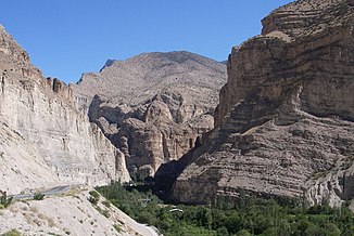
Valley of the Tortum Çayı (at the lower reaches) |
||
The Tortum Çayı is a left tributary of the Oltu Çayı in eastern Turkey .
The Tortum Çayı rises in the mountains southeast of the city of Tortum . The river flows mainly in a northerly direction. It passes the city of Tortum and Uzundere, 30 km further north . The national road D950 follows the course of the river. After another 10 kilometers, the Tortum Çayı flows into the southern end of the Tortum Gölü ( Tortum Lake ), an originally natural lake, the water level of which was raised by 1.5 m by a dam at the northern end of the lake. The water is fed to a hydroelectric power station via canals. In the wettest months, part of the water flows in the old river bed and falls down the 48 m high Tortum waterfall . In the lower reaches of the Tortum Çayı flows through a deep gorge and after about 15 km reaches the Oltu Çayı, which flows westwards. The Çayı Tortum has a length of 112 km. It drains an area of 2100 km².
