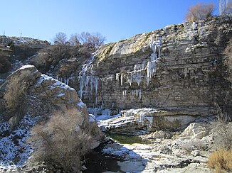
Tortum waterfall
| Tortum waterfall | ||
|---|---|---|
|
Tortum waterfall in February |
||
| Coordinates | 40 ° 39 '40.8 " N , 41 ° 40' 4.1" E | |
|
|
||
| place | 20 km north of Uzundere in the province of Erzurum ( Turkey ) | |
| height | 48 m | |
| Falling watercourse | Tortum Çayı | |
| Estuarine waters | Tortum Çayı → Oltu Çayı → Çoruh | |
The Tortum Waterfall is a waterfall in Turkey located below Lake Tortum , 100 kilometers north of Erzurum in the Uzundere district .
A landslide blocked the valley through which the Tortum Çayı River flowed. The resulting lake is eight kilometers long and one kilometer wide. The water paved a new path through the valley, which led over a 48-meter-high cliff. The break off point to the left of the slope of the Kemerlidağ on the left side of the valley of the landslide is still clearly visible.
Some geologists believe it was a very ancient landslide. On the other hand, there is another theory that this is a comparatively young landslide, which can be a few centuries old at most.
Tortum waterfall was the highest waterfall in Turkey. Since the completion of the Tortum hydropower plant in 1960, the water contained in Lake Tortum has flowed through canals and pipes to the turbines. The waterfall is only fed by the excess water for a very short time in the months of May and June, when the water level in the lake is particularly high. In the remaining months the river bed and the waterfall are almost dry.
The area around the waterfall has become a recreational area for tourists. An observation platform makes it possible to admire the waterfall up close. The bridge downstream of the waterfall can be reached by stairs.
After the waterfall, the Tortum river flows over an impressive cascade of small waterfalls down into the Tev valley.
Tortumsee
The landslide not only formed Lake Tortum with the waterfall, but also four other small lakes. These four remarkably clear and blue lakes, Incegöl, Karagöl, Efendigilin Gölü and Nazlıgilin Gölü, are fed by seepage water and are home to large numbers of trout .
Lake Tortum is surrounded by limestone from the Cretaceous period . On the eastern coast of the lake, layers of earth that can be traced back to the landslide are visible. The lake is about 100 meters deep at its deepest point.

