
Artvin
| Artvin | ||||
|
||||
 Central upper and middle part of the city |
||||
| Basic data | ||||
|---|---|---|---|---|
| Province (il) : | Artvin | |||
| Coordinates : | 41 ° 11 ' N , 41 ° 49' E | |||
| Height : | 345 m | |||
| Residents : | 26,078 (2019) | |||
| Telephone code : | (+90) 466 | |||
| Postal code : | 0800 | |||
| License plate : | 08 | |||
| Structure and administration (as of 2019) | ||||
| Structure : | 7 Mahalle | |||
| Mayor : | Demirhan Elçin ( CHP ) | |||
| Website: | ||||
| Artvin County | ||||
| Residents : | 35,186 (2019) | |||
| Surface: | 1,141 km² | |||
| Population density : | 31 inhabitants per km² | |||
| Kaymakam : | Yılmaz Doruk | |||
| Website (Kaymakam): | ||||


Artvin ( Georgian ართვინი Artwini , Armenian Արդվին Ardwin ) is the capital of the province of the same name in northeastern Turkey belonging to the Black Sea region . It also forms the central land (Merkez) of the province. The city lies on the eastern slope of the Pontic Mountains high above the Çoruh river valley . The district town is home to around 72 percent of the district's population.
history

The area around Artvin shows the remains of a settlement that dates back to 2000 years before our era. In 646 the area around Artvin was conquered during the Arab invasion. After that, the supremacy changed several times between Byzantines and Arabs . During this eventful time, Livane Castle was built down near the river to watch the invasion of enemy armies. From 1068 the Seljuks ruled here . After a Georgian interlude, the place fell again under Seljuk rule. Later Artvin was a border principality of Azerbaijani Atabegs . In the 13th century the Mongols and Ilkhan came and in the 15th century Artvin was under the rule of Uzun Hasan , who left the local rulers in their office. In the Ottoman Empire Artvin maintained a semi-independent status for a while after Crown Prince Selim I defeated the Georgians who had temporarily conquered Artvin.
In the Russo-Ottoman War of 1877–78, Russia conquered northeast Turkey and Artvin. According to the census carried out in the Russian Empire, 52,434 people lived in the Artvin district, including 50.3% Turks , 34.5% Georgians and 14.8% Armenians . The city of Artvin was mostly inhabited by Armenians, while the surrounding area was inhabited by Georgians and Turks.
With the peace treaty of Brest-Litovsk at the end of the First World War, the area fell back to the Turks.
Church history
From 1850 de jure to 1972 Artvin was the seat of an Armenian Catholic bishop ( Artuinensis Armenorum ) of the Patriarchate of Cilicia . But the chair could not be filled under Russian rule (from 1878). Catholics of the Latin rite of the Artvin region were subordinate to the Roman Catholic Bishop of Tiraspol (seat: Saratov ) in the Tsarist period , from 1912 also the Armenian Catholic Christians, from 1921 a priest as apostolic administrator based in Tbilisi (Georgia), later on an interim basis , in the end only nominally a vicar.
Cityscape
The center of Artvin is located above expressway 10, which leads southeast from the Black Sea to Ardahan and Kars, and can be reached via a five-kilometer, steep serpentine road from the junction. The bus station for long-distance buses is located in the separate suburb of Köprübaşı (also Çarş ) near the junction on the river bank. The entire city center extends along the main street İnönü Caddesi and some winding side streets halfway up the mountain slope. There is practically no flat surface in the city area. As a provincial center, Artvin has appropriate administrative buildings, a bank and several hotels. Many of the simple hotels also function as brothels.
Almost all the existing houses were built from the last quarter of the 20th century. Apartment blocks shape the cityscape. Hardly more than two houses with baroque facades in the Russian style have survived from the time of Russian rule. The mosque in the Çarşı ( Çarşı Camii ) district dates back to 1861/62. The Salih Bey Mosque ( Salihbey Camii ) was completed in 1792.

Center square ( Meydanı ) with the main mosque Halitpaşa Camii from 1991

Possibly the only remaining detached Russian-style house
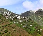
Photo by Sergei Michailowitsch Prokudin-Gorski , 1912. Same direction of view to the northwest as the cover picture


district
As a central district ( Merkez ), Artvin has borders with all other districts in the province - with the exception of the three coastal districts Kemalpasa , Hopa and Arhavi on the Black Sea. It forms an external border in the southeast with the district of Olur in the province of Erzurum . The district covers about 15 percent of the provincial area and is the third largest of its kind. It houses about a fifth of the provincial population and is slightly above the provincial average of 23.5 with its population density . In addition to the district town, it consists of 36 villages ( Köy , plural: Köyler ) with an average population of 269 inhabitants. Two of them have more than a thousand inhabitants: Seyitler with 2,178 and Ortaköy with 1,182 inhabitants. The remaining 35 Köy have fewer than 500 inhabitants.
Population development
The population is made up of Turks , Georgians , Lases and Kurds .
The following table shows the comparative population level at the end of the year for the province, the central district and the city of Artvin as well as the respective share at the higher administrative level. The figures are based on the address-based population register (ADNKS) introduced in 2007.
| year | province | district | city | ||
|---|---|---|---|---|---|
| real | percent | real | percent | real | |
| 2018 | 174.010 | 20.16 | 35,081 | 72.43 | 25,408 |
| 2017 | 166.143 | 21.02 | 34,926 | 76.45 | 26,700 |
| 2016 | 168,068 | 20.60 | 34,626 | 76.04 | 26,329 |
| 2015 | 168,370 | 20.32 | 34.208 | 75.53 | 25,838 |
| 2014 | 169,674 | 20.07 | 34,050 | 74.96 | 25,525 |
| 2013 | 169.334 | 19.73 | 33,415 | 75.39 | 25.192 |
| 2012 | 167,082 | 20.16 | 33,692 | 76.49 | 25,771 |
| 2011 | 166.394 | 20.03 | 33,333 | 75.70 | 25,234 |
| 2010 | 164,759 | 19.80 | 32,627 | 74.64 | 24,354 |
| 2009 | 165,580 | 19.92 | 32,985 | 74.18 | 24,468 |
| 2008 | 166,584 | 19.37 | 32,272 | 72.90 | 23,527 |
| 2007 | 168.092 | 19.53 | 32,827 | 74.64 | 24,502 |
Climate table
| Artvin (613 m) | ||||||||||||||||||||||||||||||||||||||||||||||||
|---|---|---|---|---|---|---|---|---|---|---|---|---|---|---|---|---|---|---|---|---|---|---|---|---|---|---|---|---|---|---|---|---|---|---|---|---|---|---|---|---|---|---|---|---|---|---|---|---|
| Climate diagram | ||||||||||||||||||||||||||||||||||||||||||||||||
| ||||||||||||||||||||||||||||||||||||||||||||||||
|
Average monthly temperatures and rainfall for Artvin (613 m)
|
||||||||||||||||||||||||||||||||||||||||||||||||||||||||||||||||||||||||||||||||||||||||||||||||||||||||||||||||||||||||||||||||||||||||||||||||||||||
Personalities
- Nerses Akinian , mechitarist monk and armenologist (1883–1963)
Twin town
Individual evidence
- ↑ a b Türkiye Nüfusu İl ilçe Mahalle Köy Nüfusları , accessed on April 9, 2020
- ^ Notes on the Armenian Catholic Eparchy of Artvin.
- ^ Artvin. ( Memento of the original from October 6, 2011 in the Internet Archive ) Info: The archive link was inserted automatically and has not yet been checked. Please check the original and archive link according to the instructions and then remove this notice. artvindenegi.com
- ↑ Central Dissemination System / Merkezi Dağıtım Sistemi (MEDAS) of the TÜIK , accessed on May 5, 2019
