Balkan Mountains
| Balkan Mountains (Stara Planina) | |
|---|---|
|
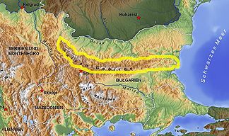
The Balkan Mountains run through Bulgaria from east to west and are partly located in Serbia. |
|
|
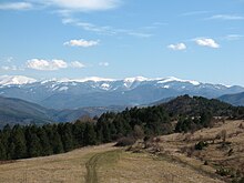
The Botev peak in the Central Balkans National Park |
|
| Highest peak | Botew ( 2376 m ) |
| location | Southeast Europe :; Bulgaria , Serbia |
| Coordinates | 43 ° N , 25 ° E |
| Type | Ceiling / fold mountains |
| Age of the rock | Alpidian phase (100–50 mya) |
|
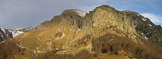
The main ridge in the Middle Balkans at the Ambariza summit |
|
The Balkan Mountains , or Balkans for short ( Cyrillic Балкан ), Bulgarian and Serbian Stara Planina ( Cyrillic Стара планина ), is a Tertiary folded mountain range in southeastern Europe , the main ridge of which is in Bulgaria . It is part of the Alpidic mountain system . The Balkan Peninsula was named after the mountains .
In the area were a National Park , four nature reserves ( Sinite Kamani , Balgarka , Wratschanski Balkan and Stara Planina ) as well as several nature reserves and protected areas to protect the flora and fauna established.
Names
In ancient times , the Balkan Mountains were called Hemus ( Bulgarian Хемус ), ancient Greek Αἵμος ; Thracian Haimos , Latin Haemus . This name was also used when naming the Montes Haemus on the moon as well as the former Bulgarian airline Hemus Air and the Bulgarian highway Awtomagistrala Hemus .
Between the 14th and 17th centuries, the Ottoman Turks gradually conquered the area and were the dominant power there until around the end of the 19th century. Accordingly, the name Balkan comes from the Turkish language and means “steep mountain range”, “area (s) with many trees, bushes and bushes” or “mountain (s) with many forests”.
There is also a mountain range in Turkmenistan called the Great Balkans ("Uly Balkan"), there is also the province of Balkan welaýaty with the capital Balkanabat . It is likely that the name Balkans was transferred from there to the mountains in southeastern Europe, as the ancestors of the Ottomans and Turks, the so-called Oghusen , came from this area in Central Asia.
The Bulgarians and Serbs call the mountains today Stara Planina ('old mountains', Стара планина ), with the term Balkan also being used in Bulgarian .
geography
location

The Balkan Mountains are about 600 km long and run on the northern edge of the Balkan Peninsula to the plains of the Lower Danube in a west-east direction. The mountains form the natural northern border of the Thrace landscape . The mountain range with rounded mountain shapes slopes steeply to the south and is crossed by many passes , of which the Schipka Pass and the Pass of the Republic are the most important. It is also cut by several breakthrough valleys , of which the Iskar is the most powerful. The highest peak is the Botew ( 2376 m ).
structure

The mountain range is divided into three sections from west to east:
- Western Balkans: up to 2169 m high ( Midžor ), natural border between Serbia and Bulgaria
- Middle Balkans (also “High Balkans”): from the Iskar breakthrough or the Botevgrad pass in the west to the Wratnik pass in the east
- Eastern Balkans (also "Little Balkans"): The central main ridge extends to the Black Sea coast and ends there at Cape Emine
Structure from north to south:
- Vorbalkan (also "Predbalkan")
- Main ridge of the Balkan Mountains ( Bulgarian подобласт на Главната Старопланинаска верига podoblast na Glavnata Staroplaninska veriga ), in the center of the Botev peak
- Subbalkan (also "Podbalkan")
The main ridge and the pre-Balkans form the large landscape of the Balkan chain system ( Bulgarian Област на Старопланинска верижна система Oblast na Staroplaninska verischna sistema ). The northern Bulgarian Danube Plain joins in the north .
geology

The folding phase of the Balkan Mountains is assumed in the Old Tertiary. The alpine mountain folding phase Belonging are the Balkanzug and the Carpathian arc structurally related parts of the northern Alpine mountain chain. Structurally geologically referred to as the Carpatho-Balkan Arc, it occupies a substantial part of the northern central and eastern Balkan peninsula south of the Danube.
Geologically, the Balkans is determined by a zonal structure of north-south striking rock structures. This zonal strike direction is broken up by tectonic rotations in the north and south, which are characteristic of the curved mountain arch.
Rocks from the Proterozoic to the Quaternary build the mountain range. These are predominantly acidic metamorphic rocks ( orthogneiss ) of the Sredna Gora . There are often limestones and, to a lesser extent, dolomites from the Jura and Lower Cretaceous . The thickness of these sediments can be more than 1000 m. Limestones from the Triassic , on the other hand, are rarer. They can be found on the ceiling of Permian sandstones in the western Balkans and in the eastern Stara Planina.
relief
The relief of the Balkan Mountains is determined in particular in the Stara Planina, as well as on the south side of the Central Balkans, by an abrupt rise, but on the north side by a gradual transition from the loess-covered Danube plain. On the north side, the hilly promontory of the Balkans occupies heights between 250 and 600 m. In contrast, the steep slopes on the south side of the central Balkan plain of Bulgaria are seamless.
In the Eastern Balkans the heights decrease and the mountains dissolve into several parallel chains (Kotlenska, Warbischka, Kamtschijska planina in the north, Sliwenska, Stidowska, Karnobatska, Eminska planina in the middle, Grebenez, Tersijski bair, Chisar, Ajtoska planina in the South). The middle ridge line mostly remains below the tree line (1900 m), but the mountain parts that protrude beyond it are also broadly covered by alpine pastures . Between the eastern parallel chains there are long valleys, the largest of which is traversed by the Luda Kamchija river.
The basin landscape in the south

To the south, the main chain of the Balkans drops steeply to the basins of the Sub-Balkans, which already belong to another large landscape, the so-called mountain-basin transition zone ( Bulgarian : Преходна блоково-разломна планинско-котa-kotovo plan- kotko-bloinskotovo-rodinskolast ). These trench-like depressions follow one another from west to east, their northern limit is a mighty fault line. The most important among them are
- the Slatiza plain with the towns of Slatiza and Pirdop, through which the Topolnitsa River flows,
- the Karlowo plain with the town Karlowo and the Strjama as the main river,
- the elongated Kazanlak basin with the town of Kazanlak , traversed by the tundscha in an easterly direction . The eastern part of this basin with Twardiza as the main town is separated by the Debelez and Mezdenik mountains .
The Karlowo plain and the Kazanlak basin are also combined to form the so-called Rose Valley .
The basin character of the Slivensko pole , which is also traversed by the tundscha and in its eastern part by the Motschuriza, and in the north mainly by the mountain massifs of the Balkan mountains Grebenez and Terzijski bair, in the south by the eastern foothills of the Sarnena gora and in the south, is less pronounced the ridge of the Bakadschizi is limited.
The zone of the sub-Balkan basin is bounded in the south by the Sredna Gora (also Srednogorie, German low mountain range) with which they form the Sredna gora-Podbalkan transition zone (Bulgarian Средногорско-Подбалканска подобласт-Podredobblastogorsko / Sredna gora-Podrednalkogorska).
economy
Sheep breeding is predominant in the higher elevations and forestry is practiced in the deciduous forests . Agriculture predominates in the fertile valleys . In addition, there are significant hard coal deposits in the region .
The sheep in the Stara Planina, on autochthonous Zackel sheep types , especially the white Pirot - ( Pirotska Pramenka ) and dark Karakatschaner sheep ( Karakačanska ovca ), whose long wool, elastic fibers is formed from 30-40 microns in diameter, provided the The basis of the traditional kilim weaving in the places where Pirot and Tschiprowzier kilims are made . Along with wool production, the historical production centers of the Şarköy weaving mills in western Bulgaria, which were cultivated by Orthodox Slavs, developed in the Stara Planina.
The preservation of traditional autochthonous sheep breeding is now a priority, as it has remained the basis for today's kilim production in the Stara Planina. From the formerly important herd-keeping on the Serbian side, only about 500–1000 pirot and 100 Karakachan sheep remained.
The sheep breeding of the Stara Planina originally went back to the needs of cheese production, from which the kačkavlj produced here was introduced in the Stara planina by nomadic Karakačans at the beginning of the 19th century . In addition to the wool for the kilim weaving mills, the hard cheese was the most important commodity in the economic relations of Pirots, Caribrods and Tschiprowitzs in the Ottoman Empire .
Projects to preserve the autochthonous domestic animal breeds of the Stara Planina are currently also being undertaken to set up organically managed farms.
Web links
Individual evidence
- ↑ tdk.gov.tr
- ↑ a b c d e Peter Soustal: Thrace (Thrace, Rhodope and Haimimontos). Tabula Imperii Byzantini Volume 6, Verlag der Österreichischen Akademie der Wissenschaften, Vienna 1991, ISBN 3-7001-1898-8 , pp. 53–55.
- ↑ Valentin Burtmann: Origin of structural arcs in the Carpathian-Balkan region . In: Tectonophysics. vol. 127, 1986, pp. 245–260, Amsterdam geo.edu.ro ( Memento of the original dated February 1, 2012 in the Internet Archive ) Info: The archive link was inserted automatically and has not yet been checked. Please check the original and archive link according to the instructions and then remove this notice. (PDF; 1.2 MB)
- ↑ Milena Zlokolica-Mandic: Structural-Tectonic element as a factor in Cave Development . In: Speleological Atlas of Serbia. SANU (Serbian Academy of Sciences), Belgrade. sanu.ac.rs ( Memento of the original from July 27, 2011 in the Internet Archive ) Info: The archive link was automatically inserted and not yet checked. Please check the original and archive link according to the instructions and then remove this notice.
- ↑ EM Fotakiewa, M. Minkov: The loess in Bulgaria . In: Ice Age and the Present. Vol. 17, 1966, pp. 87-96, Öhringen. (online at: quaternary-science.publiss.net ) ( Memento of the original from March 5, 2016 in the Internet Archive ) Info: The archive link was inserted automatically and has not yet been checked. Please check the original and archive link according to the instructions and then remove this notice.
- ^ Sergej Ivanov: Importance of Zackel sheep breed in development of Pirot and Chiprovtsi kilim brand in the stara planina region. ( Memento of the original from June 9, 2015 in the Internet Archive ) Info: The archive link was inserted automatically and has not yet been checked. Please check the original and archive link according to the instructions and then remove this notice. (PDF; 2.4 MB)
- ↑ Centar za očuvanje autohotnih rasa Rase ovaca i koza
- ^ M. Ostojić, V. Lazarević, R. Relić: Autohotni pirotski kačkavalj. In: Radovi sa XXV savetovanja agronoma, veterinara i tehnologa. Vol. 17. br. 3-4, pp. 79-84. pkbae.rs (PDF; 4.5 MB)
- ^ Sergej Ivanov: Milina organic - Agrobiodiversity Conservation - Project in Serbia. ( Page no longer available , search in web archives ) Info: The link was automatically marked as defective. Please check the link according to the instructions and then remove this notice. (PDF; 1.9 MB)


