Talysh Mountains
| Talysh Mountains | ||
|---|---|---|
|
Satellite image of the Talysh Mountains |
||
| Highest peak | Kömürgöy ( 2477 m ) | |
| location | Azerbaijan , Iran | |
| part of | Elburs | |
|
|
||
| Coordinates | 38 ° 42 ' N , 48 ° 18' E | |
The Talysh Mountains ( Persian کوههای تالش, DMG Kūh-hā-ye Tāleš ; Azerbaijani Talış dağları ) is a mountain range in northwestern Iran and southeastern Azerbaijan of about 100 kilometers in length.
It is located in the northwestern part of the Elburz Mountains and extends from the Lenkoran lowlands in southeastern Azerbaijan to the lower part of the Sefid Rud river in northwestern Iran.
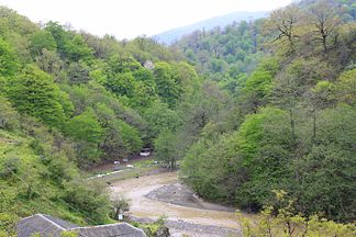
The highest peak is the Kömürgöy with 2477 m . On the eastern slopes, the Talysh Mountains are dominated by a humid subtropical climate up to around 600 m, with precipitation between 1,600 mm and 1,800 mm. This makes the mountain range the wettest region in Azerbaijan and one of the wettest regions in Iran. The mountain range is covered with Hyrcania mixed forest up to about 600 m , after which the vegetation level becomes montane. The border river Bolgar-Tschaj drains the mountains to the north.
Web links
Individual evidence
- ↑ Article Talysh Mountains in the Great Soviet Encyclopedia (BSE) , 3rd edition 1969–1978 (Russian)


