Kordestān
| استان کردستان Kordestān
|
|
|---|---|
| Location of the province of Kordestān in Iran | |
| Basic data | |
| Country | Iran |
| Capital | Sanandaj |
| surface | 29,137 km² |
| Residents | 1,603,011 (2016 census) |
| density | 55 inhabitants per km² |
| ISO 3166-2 | IR-16 |
Coordinates: 35 ° 44 ' N , 46 ° 58' E
Kordestān , also Kurdistan or Kordestan ( Persian استان کردستان Ostān-e Kordestān , Kurdish کوردستان Kurdistan ), is one of the 31 provinces of Iran . It is part of the Kurdish settlement area and should not be confused with the larger geographic area of Kurdistan .
1,603,011 people live in the province (2016 census). The area of the province extends to 29,137 square kilometers. The population density is 55 inhabitants per square kilometer.
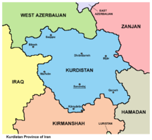
Kordestān is located in western Iran on the border with Iraq . In the north lies the province of West Azerbaijan , in the northeast Zanjan , in the east Hamadan and in the south Kermanshah .
The capital of the province is Sanandaj (in Kurdish Sine ) with 316,862 inhabitants (2006 census). Other big cities are Marivan , Baneh , Saqqez , Qorveh and Bidschar .
geography

Since the entire Kordestān is mountainous, there are a large number of rivers, lakes, glaciers and caves here. This makes Kordestān a major destination for tourists and mountaineers.
One of the longest rivers is the Zarrinehorood , which is 302 km long and flows into Lake Urmia . The Sirvan River, for its part, flows west into Iraq and finally flows into the Tigris . Lake Zarivar is one of the most beautiful lakes in Kordestān. It is 3 m on average, but 50 m deep at its deepest point. It is 1.7 km wide and 5 km long. The lake is surrounded by thick forests and is located west of Marivan.
There are also mineral springs here, such as Govaz near Kamyaran, Abetalkh near Bidschar and Baba Gargar near Ghorveh. A famous cave is Kereftoo at Divanderre, where sanctuaries are built within the cave. One temple is dedicated to the Greek god Heracles . The Schoovi Cave is 267 m long and is located near Baneh. The highest mountain is the Chehelcheschmeh at 3330 m . Other mountains are Hossein Bak with 3091 m and Masjede Mirza with 3059 m .
The fauna consists of leopards , rams , wild goats , hyenas , jackals , wolves , foxes , sables , weasels and birds such as partridges , wild ducks, storks and eagles. Kordestān is located in the Zagros Mountains . Therefore it has a typical continental climate with long cold winters.
administration
The province is structured as follows:
| Shahrestan (administrative district) | Bachsch (district) | main place |
|---|---|---|
| Baneh | Armardeh, Baneh, Buin-e Sofla, Kani Sur | Baneh |
| Bidschar | Bijar, Babarashani, Yasukand | Bidschar |
| Divanderre | Divanderre, Zarrineh | Divanderre |
| Dehgolan | Dehgolan, Bolbanabad | Dehgolan |
| Kamyaran | Kamyaran, Muchesch | Kamyaran |
| Marivan | Marivan, Chenareh, Kani Dinar | Marivan |
| Qorveh | Qorveh, Delbaran, Dezaj, Serishabad | Qorveh |
| Sanandaj | Sanandaj, Shuyescheh | Sanandaj |
| Saqqez | Saqqez, Saheb | Saqqez |
| Sarvabad | Sarvabad | Sarvabad |
history
Kordestān, along with the entire Zagros region, is one of the earliest settlements for the Medes and Persians . From here, the Assyrian Empire was established in 612 BC. Subjected to BC. After the defeat of the Sasanids by the Muslim Arabs in AD 634 , Iran became Muslim . However, from time to time there were regional uprisings. The Kurds rebelled against the caliph al-Mutasim here in 835 .
In the following centuries, Kordestān, like other regions, was devastated by the Mongols and Timur Lenk . After the Europeans used the sea route for trade with India and China as an alternative to the Silk Road in the 16th century , Kordestān lost its economic importance. Sultan Mohammed Chodabandeh built the place Sultanabad Chamchal near the Bisutun region around 1220 as the administrative seat of the province . In 1372 the administration moved to Hassanabad , which is 6 km south of Sanandaj. In the 13th century, the Kurdish Ardalan dynasty came to power and ruled Kordestān until 1867.
population
Half of the population of 1.6 million people (2006 estimate) live in cities. Much of the people are Kurds , most of whom speak Sorani . The Sorani is also called Ardalani here . Other Kurdish dialects are Hewramani (near Marivan) and Kurmanji . Azerbaijanis also live in the eastern parts of the province, near Bidschar and Qorveh . Persians are a minority.
Economy and Infrastructure
The province lives from agriculture and animal husbandry. Agricultural products are wheat, barley, grain and fruits. The industry consists of chemical, metal, leather and food industries.
Colleges and universities
- Kurdistan Medical University
- Tohid Medical Center
- University of Kurdistan
- Azad Islamic University in Sanandaj
Attractions
The cultural authority of Iran lists 211 cultural and historical sites worth seeing that are located in Kordestān. One of them, namely the Ghal'eh Kohneh near Bidschar, dates from the time of the Sassanids.
Web links
Individual evidence
- ↑ City Population: Iran - Cities and Provinces .


