
Ilam (province)
| ایلام Ilam
|
|
|---|---|
  |
|
| Basic data | |
| Country | Iran |
| Capital | Ilam |
| surface | 20,133 km² |
| Residents | 580,158 (2016 census) |
| density | 29 inhabitants per km² |
| ISO 3166-2 | IR-05 |
Coordinates: 33 ° 11 ' N , 46 ° 53' E
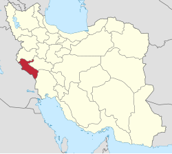
Ilam (or Elam ; Persian ایلام, Kurdish ئیلام Îlam ) is one of the 31 provinces of Iran with the capital of the same name, Ilam .
580,158 people live in the province (2016 census). The area of the province extends to 20,133 square kilometers. The population density is 27 inhabitants per square kilometer.
geography
Ilam is located in the southwest of the country and borders Iraq . Cities in Ilam are Mehran , Dehloran , Dareh Shahr , Shirvan Va Chardavol , Aivan and Abdanan . The province can be topographically divided into two zones. The highlands of the Zāgros Mountains , which occupy the northern and eastern areas of the province, and the low plains in the southwest of Ilam. The highest mountains and mountain ranges in the province are the Ban-Kuh at 3,304 meters, followed by the Kabir-Kuh - an approximately 260 km long chain that divides the larger region into Poschtkuh and Pischkuh Lorestan (this side and the other side of Lorestan). Ilam is Poschtkuh and today's Lorestan Pischkuh. The highest point of the Kabir-Kuh is 2790 m. Other high mountains are the Sharazul with 2050 m, the Dinar-Kuh with 1955 m and the Shah-Nakjir with 1898 m. These whole mountains are the origin of many springs, which then either flow eastwards into the Seymare / Karke or flow westwards towards Iraq.
The majority of the inhabitants are Lurs . Shiite Kurds also live here. The Gorani and Leki dialects are common among the Kurds .
history
The associated area was in earlier times part of the kingdom of Elam , which was incorporated into the Persian Empire and from which the name of the province is derived. In Elamite and Babylonian inscriptions, the province was called Alamto or Alam , which meant "mountains" or "land of sunrise".
After the Achaemenids and the Macedonians , the Sassanids conquered the area. Kurdish tribes ruled the area from the late 11th to the 13th centuries.
In 1930 Ilam still belonged to the province of Kermanshah and was known as the Poschtkuh of Lorestan (this side of Lorestan) until it was given its current name in 1936 based on the Elamites.
Attractions
- Imamzadehs (shrines from the Middle Ages ): Imamzadeh Ali Saleh, Imamzadeh Seyd mammad Abed, Imamzadeh Seyd Akbar, Imamzadeh Seyd Fakhreddin, Imamzadeh Seyd Nasereddin, Imamzadeh Ibrahim, Imamzadehambahim, Imamzadehambahim, Imamzadeh Mehdammadeh Mdh, Imamzadeh Mehdamadeh, Piramzadeh Mehdam, Imamzadeh Mdhadzadeh, Piramzadeh Mehdamm, Imamzadeh Abduladeh Muhammad Imamzadeh Ibrahim Qetal, Imamzadeh Seyd Hasan, Imamzadeh Seyd Salaheddin Muhammad, Imamzadeh Haji Bakhtiar, Imamzadeh Haji Hazer, Imamzadeh Jabir.
- Ruins of Zoroastrian fire temples : Siyahgol Iwan, Chahar Taghi in Darreh Shahr.
- Palaces, forts and castles: Ghal'eh Vali ( Qajar era), Posht Ghal'eh Chowar, Ghal'eh Paghela Chekarbuli, Ghal'eh Falahati (Qajar era), Shiagh Castle in Dehloran ( Sassanid era), Ismail Khan Fort, Sam Castle (late Parthian era), Pur Ashraf castle, Mir Gholam Hashemi ghal'eh, Posht Ghal'eh Abdanan (Sassanid era), Konjancham fort, Shirin and Farhad Iwan in Mehran (Parthian era ), Hezar Dar Castle (Sassanid era), Sheikh Makan Fort (Sassanid era), Zeinal Fort.
- Bridges from the Sassanid era
- Archaeological sites and ruins from the Sassanid era and later
- Ancient reliefs
- Ruins of ancient settlements
- Springs, caves (including Zinegan caves) and nature parks
Administrative division
The province is divided into seven districts.
| map | Abbreviation in map | Counties |
|---|---|---|

|
||
| A. | Abdanan | |
| There | Darrehschahr | |
| De | Dehloran | |
| E. | Eevan | |
| I. | Ilam | |
| M. | Mehran | |
| ShCh | Shirvan-o-Chardavol |
Colleges
- Ilam University of Medical Sciences
- University of Ilam
- Islamic Azad University of Ilam
- Payame noor University of Ilam
Web links
Individual evidence
- ↑ City Population: Iran - Cities and Provinces .
Alborz | Ardabil | Bushehr | Khuzestan | Fars | Qom | Gilan | Golestan | Hamadan | Hormozgan | Ilam | Isfahan | Kerman | Kermanshah | Kohgiluye and Boyer Ahmad | Kurdistan | Lorestan | Markazi | Māzandarān | North Khorasan | East Azerbaijan | Qazvin | Razavi-Khorasan | Semnan | Sistan and Balochistan | South Khorasan | Tehran | Tschahār Mahāl and Bakhtiyāri | West Azerbaijan | Yazd | Zanjan
Former provinces: Khorasan
Abdanan | Darrehschahr | Dehloran | Eyvan | Ilam | Malekschahi | Mehran | Shirvan-o-Chardavol