Matebian
| Matebian | ||
|---|---|---|
|
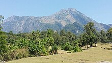
Harvested rice fields in the foreground of the Matebian massif |
||
| height | 2316 m | |
| location | Suco Bualale , Quelicai Administrative Office , Baucau Municipality , East Timor | |
| Coordinates | 8 ° 38 '26 " S , 126 ° 35' 49" E | |
|
|
||
| Normal way | Mountain Tour of Quelicai Subdistrict from | |
| particularities | One of the sacred mountains of the Timorese | |
|
The Matebian with the Seiçal River in the foreground |
||
|
The limestone formations on the summit of Matebian |
||
The Matebian ( Mata Bia, Maté Bian, Mount Matebian, Gunung Boica, Gunung Mata Bia, Gunung Matabai, Meme Malabia, Malobu , 2316 m ) is the third highest mountain in East Timor . Colonial sources even give it a height of 2368 m , which would make Matebian the second highest mountain. His name means "mountain of souls" or "mountain of the dead". The mountain is considered sacred because the spirits of the ancestors are supposed to live here. Another name for the mountain is " Bere (large) Meta " (black) among the Makasae .
Geography and advancement

The mountain is located in the east of the Quelicai administrative office , in the south of the municipality of Baucau . It has two peaks: the Matebian Mane ( German Matebian of the men ) on the northeast border of the Sucos Bualale and north of the Matebian Feto ( German Matebian of the women ) in the Suco Lacoliu . The lower Matebian Feto is best reached from Quelicai . To get to Matebian Mane, one must first go to the village of Osso Huna , six kilometers south of Baguia. From there it takes half an hour to walk to the village of Oeiburu , from where the ascent begins. Most of the time you rest in tents in order to get to the mountain at night and experience the sunrise on the summit. It takes about two and a half hours to get to the top. From here you can see the north and south coast of Timor.
The massif forms one of those large inland cliffs that the locals call fatu . Due to its isolated location, the mountain dominates this part of the island and can even be seen from the north coast. The Boicau ( 2100 m ) also belongs to the Matebian massif .
Striking limestone needles and other formations are noticeable on the mountain, for example at 2080 m on the Matebian Feto and on the summit of the Matebian Mane. A statue of Jesus (Cristo Rei) has stood on the summit of Matebian Mane since 1993 and is visited by thousands of pilgrims every October and on All Saints' Day . After that, the path up is closed until February due to the rainy season.
Since 2000 the peaks of Matebian with the entire area over 2000 m altitude and the surrounding forest have been a game reserve. There are large amounts of manganese on the mountain .
history

The mountain and its surroundings were the last great resistance center of the FALINTIL ( base de apoio ). From 1977 evacuated civilians were settled in new villages around the Matebian according to their origin. They came from Tequinaumata , Samalari , Boleha , Guruça , Afaçá and Namanei (Baucau municipality) and Benamauc , Camea and Fatuahi . The political commissioner Abel Larisina and his adjutant Xanana Gusmão were able to organize the supply of the population with food. In mid-1977 the situation worsened when refugees arrived from Builo on Matebian. There have been victims of hunger and disease. Food was reserved for the population for the benefit of the FALINTIL fighters. In October 1978 the attacks on the base began. The resistance fighters and civilians were bombed from the air for two weeks. The bombardment was also carried out from sea while the army slowly advanced. 20 to 30 people were killed every day. On November 24th, the FALINTIL were overrun by the Indonesian invaders as part of Operation Seroja . They capitulated on November 25th. The prisoners were interned in a transit camp and separated into FALINTIL fighters and civilians. Many disappeared without a trace, the others were later moved to larger camps such as in Quelicai. You can still visit caves on the mountain today , which the resistance fighters used to hide.
Web links
Individual evidence
- ↑ Susana Barnes: Origins, Precedence and Social Order in the Domain of Ina Ama Beli Darlari , In: Land and life in Timor-Leste, p. 26.
- ^ Ministry of State Administration & Territorial Management, Timor-Leste: Baucau District profile ( Memento from March 28, 2009 in the Internet Archive ) (PDF; 276 kB)
- ↑ "Chapter 7.3 Forced Displacement and Famine" (PDF; 1.3 MB) from the "Chega!" Report of the CAVR (English)


