Metinaro
| Metinaro | ||
|---|---|---|
|
|
||
| Coordinates | 8 ° 32 ′ S , 125 ° 45 ′ E | |

|
||
| Basic data | ||
| Country | East Timor | |
| Dili | ||
| Administrative office | Metinaro | |
| ISO 3166-2 | TL-DI | |
| Suco | Sabuli | |
| height | 135 m | |
| Residents | 4316 (2010) | |
Metinaro is the capital of the East Timorese administrative office Metinaro ( municipality of Dili ). "Metinaru" means "long reef" in Nanaek .
geography
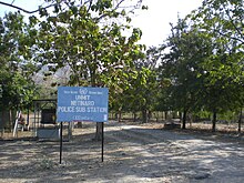
The place Metinaro is about 18 km east of the state capital Dili as the crow flies , at an altitude of 135 m . Its center is in Suco Sabuli , but the settlement extends to the neighboring Suco Wenunuc . There are two primary schools, a pre-secondary school, a police station and a community health center throughout the settlement.
Residents
4,316 people live in the village (2006).
history

In 1978 there was a camp for East Timorese in Metinaro, who were to be relocated by the Indonesian occupiers for better control. 40,000 people were held here by mid-1979.
Between July and August 1999, earlier than in the rest of East Timor, most of the residents of Metinaros had left the place due to the wave of violence . Pro- Indonesian militias ( Wanra ) had terrorized the population, 70% of the place was destroyed.
As a result of the parliamentary elections on June 30, 2007 and the subsequent commissioning of Xanana Gusmão to form a government, violent riots and fights between supporters of the new government and sympathizers of FRETILIN broke out in many parts of the country . On August 22nd, between one hundred and three hundred fought each other with machetes, steel arrows and bows. The police brought the situation back under their control, but the market was completely burned down. Three people were arrested. The next day there was another fighting in which ten houses went up in flames.
Individual evidence
- ↑ Geoffrey Hull : The placenames of East Timor , in: Placenames Australia (ANPS): Newsletter of the Australian National Placenames Survey, June 2006, pp. 6 & 7, ( Memento of the original from February 14, 2017 in the Internet Archive ) Info: The archive link was inserted automatically and has not yet been checked. Please check the original and archive link according to the instructions and then remove this notice. accessed on September 28, 2014.
- ↑ Timor-Leste District Atlas version 02, August 2008 ( Memento of the original dated December 3, 2011 in the Internet Archive ) Info: The archive link was inserted automatically and has not yet been checked. Please check the original and archive link according to the instructions and then remove this notice. (PDF; 448 kB)
- ↑ "Chapter 7.3 Forced Displacement and Famine" ( Memento of the original from November 28, 2015 in the Internet Archive ) Info: The archive link was inserted automatically and has not yet been checked. Please check the original and archive link according to the instructions and then remove this notice. (PDF; 1.3 MB) from the "Chega!" Report by CAVR (English)
