
List of mountains or elevations in East Timor


This is a list of the mountains and elevations of East Timor over 1000 m . In addition, the Mano Côco is listed here as the highest point on the island of Atauro .
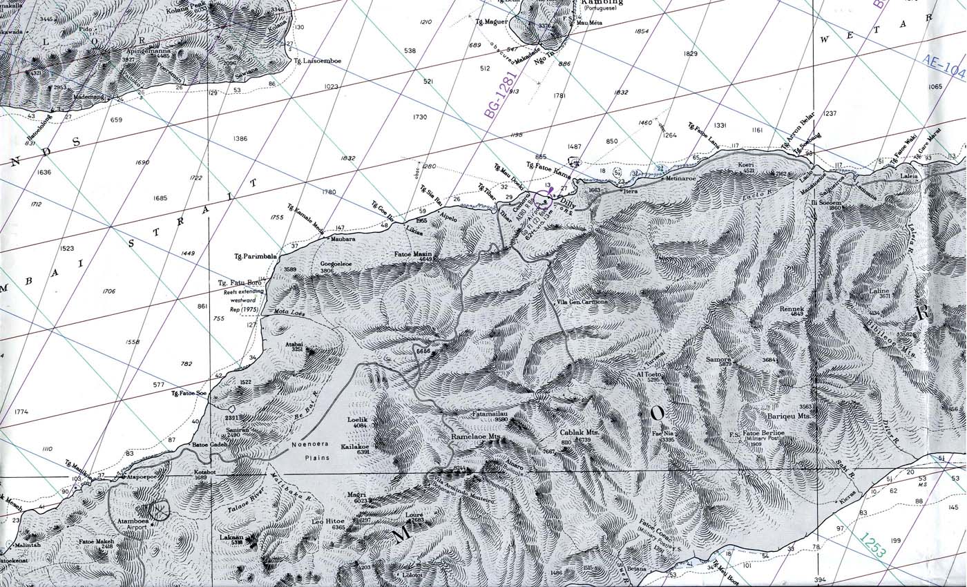
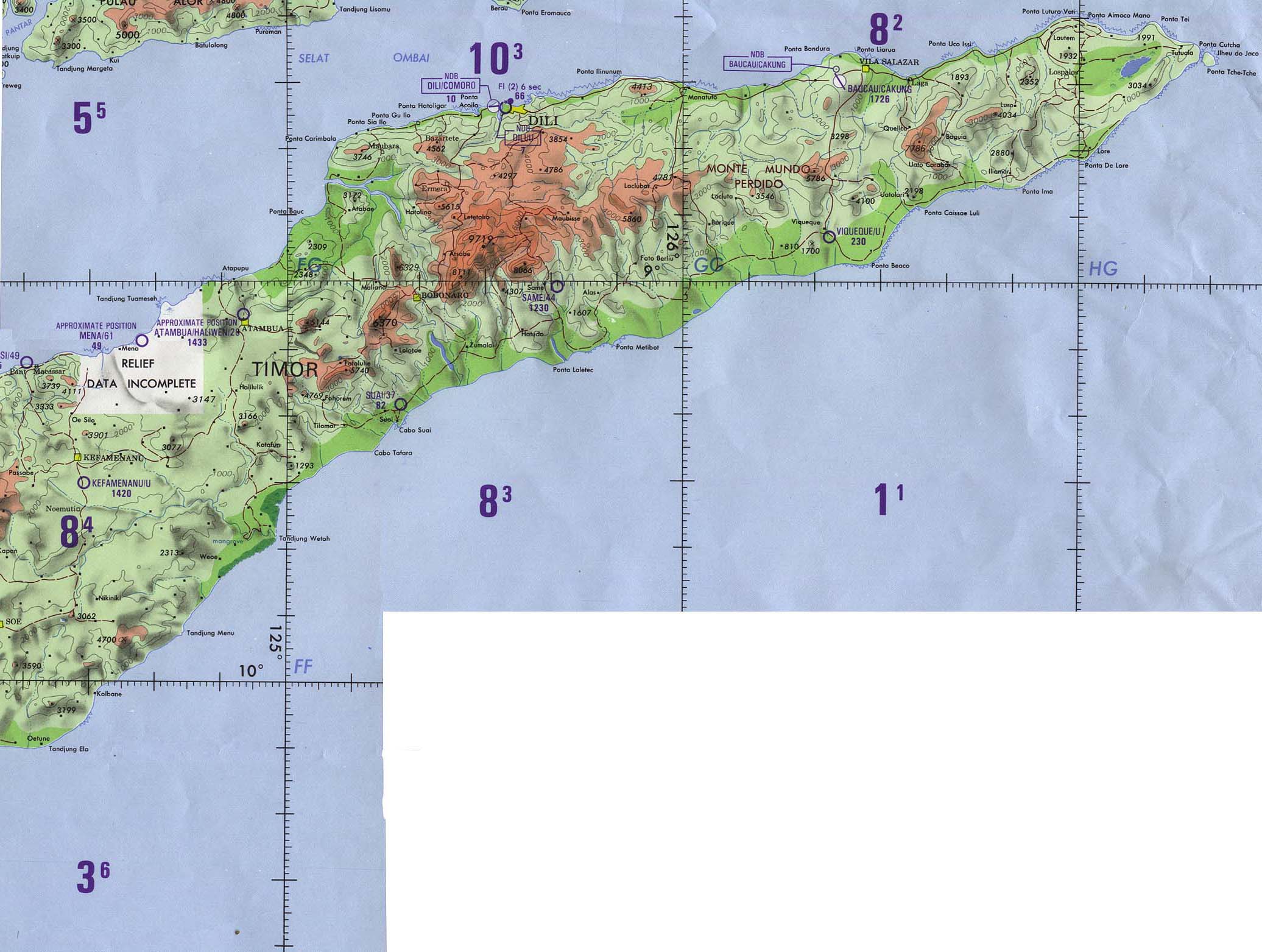
Apart from the alluvial land in the south, East Timor is characterized by its high mountains and small valleys. The highest mountain is the Tatamailau with over 2900 m in the Ramelau mountain range . There are contradicting information about the second highest mountain.
When naming and possible alternative names, it should be noted that Foho is the Tetum word for mountain . In Portuguese the word is Monte , in Bahasa Indonesia Gunung . The English term mount is increasingly found on the Internet and on newer maps. The Portuguese word pico for point is now often replaced by the English peak . With Fatu be characteristic of Timor referred steep walls, such as the Matebian massif with its 2316 m high peaks, the Monte Mundo Perdido at Ossu ( 1763 m ) and the Fatu Laritame ( 1394 m ), the part of the Cuac chain is.
The list is not complete and may contain double entries due to the alternative names. There are also missing other mountains with a height of over 2,000 meters. In addition, the altitude information can vary greatly depending on the source. The list provides an overview of the information available.
| Mountains in East Timor | ||||
|---|---|---|---|---|
| mountain | Alternative name | height | local community | position |
| Ablai | Ablaí, Foho Ablai, Monte Ablai, Darulau | 2340 m ( 2319 m , 2320 m , 2346 m ) | Ainaro | 08 ° 59 ′ S , 125 ° 36 ′ E |
| Ailora | Foho Ailora | 2013 m | Ermera | 08 ° 53 ′ S , 125 ° 36 ′ E |
| Aitana | 1235 m , 1203 m | Viqueque | 08 ° 44 ′ S , 126 ° 07 ′ E | |
| Ausulo | Foho Ausulo | 2337 m | Ermera | 08 ° 51 ′ S , 125 ° 31 ′ E |
| Bacusaga | Foho Bacusaga | 2184 m | Bobonaro | 09 ° 00 ′ S , 125 ° 25 ′ E |
| Behetalau | Foho Behetalau | 2257 m | Ainaro | 08 ° 54 ′ S , 125 ° 32 ′ E |
| Berebei | Foho Berebei | 2501 m ( 2463 m ) | Ainaro | 08 ° 56 ′ S , 125 ° 28 ′ E |
| Berelaca | Foho Berelaca | 2495 m ( 2448 m ) | Ainaro | 08 ° 57 ′ S , 125 ° 36 ′ E |
| Bisae Súnan | Bijael Sunaen , Bidjael Sunan , Nuaf Bijae Sunan | 1560 m ( 1562 m ) | Oe-Cusse Ambeno | 09 ° 30 ′ S , 124 ° 17 ′ E |
| Builo | Gunung Builo, | 1200 m , ( 1070 m ) | Viqueque | 08 ° 46 ′ S , 126 ° 28 ′ E |
| Foho Buku Mera | 1079 m , ( 1102 m ) | Liquiçá | 08 ° 39 ′ S , 125 ° 23 ′ E | |
| Cablac | Cablaque, Cablak | 2180 m ( 2297 m ) | Ainaro | 08 ° 56 ' S , 125 ° 57' E |
| Cabalaki | Foho Cabalaki, Kablaki | 2459 m ( 2020 m ) | Manufahi | 08 ° 57 ′ S , 125 ° 38 ′ E |
| Cassacaic | 1024 m , ( 1064 m ) | Viqueque | 08 ° 47 ' S , 126 ° 10' E | |
| Caterai | 2100 m | Ermera | ||
| Colimali | Foho Colimali | 2058 m | Aileu | 08 ° 50 ′ S , 125 ° 33 ′ E |
| Curi | Mount Curi, Gunung Curi | 1332 m | Manatuto | 08 ° 30 ′ S , 125 ° 54 ′ E |
| Cutulau | Foho Cutulau, Foho Kutulau | 1410 m | Liquiçá | 08 ° 39 ′ S , 125 ° 22 ′ E |
| Diatuto | Monte Dia Tuto, Mount Diatuto | 1732 m , 1781 m | Manatuto | 08 ° 49 ′ S , 125 ° 51 ′ E |
| Doramelau | Foho Doramelau, Pico Duralau (?) | 2857 m ( 2320 m , 2322 m , 2346 m ) | Ermera | 08 ° 55 ′ S , 125 ° 29 ′ E |
| Fatu Lulik | Fatu-Lulique, Fatululik | 1235 m | Cova Lima | |
| Fatumasin | Fatu Masin, Fantumasin | 1369 m ( 1180 m ) | Liquiçá | 08 ° 39 ′ S , 125 ° 22 ′ E |
| Hatofahi | Foho Hatofahi | 2678 m | Ainaro | 08 ° 56 ′ S , 125 ° 29 ′ E |
| Hatosaga | Foho Hatosaga | 2488 m | Ainaro | 08 ° 59 ′ S , 125 ° 26 ′ E |
| lame | Mount Lame, Monte Lame | ? | Baucau | |
| Laritame | Fatu Laritame | 1394 m , 1220 m | Viqueque | 08 ° 41 ′ S , 126 ° 23 ′ E |
| Laumeta | Foho Laumeta | 2678 m | Ainaro | 08 ° 56 ′ S , 125 ° 28 ′ E |
| liver | Lolo Leber, Mount Leber | 1403 m | Bobonaro | 09 ° 05 ′ S , 125 ° 12 ′ E |
| Lebolia | Foho Lebolia | 2558 m | Ainaro | 08 ° 57 ′ S , 125 ° 27 ′ E |
| Legumau | Gunung Legumau, Legumaw Monte Apara | 1297 m ( 1128 m , 1263 m ) | Lautém | 08 ° 34 ′ S , 125 ° 47 ′ E |
| Leohito | Foho Leohitu, Leohitu, Leo-Hito, Gunung Leohitu, Leo Hitoe | 1925 m ( 2169 m ) | Bobonaro | 09 ° 06 ′ S , 125 ° 14 ′ E |
| Leolaco | Foho Leolaco, Leo-Laco, Foho Cailaco, Kailakoe, Lacos | 1929 m ( 1916 m , 1947 m ) | Bobonaro | 08 ° 58 ′ S , 125 ° 16 ′ E |
| Loelik | 1392 m | Bobonaro | ||
| Makfahik | Mount Mak Fahik | ? | Manatuto | |
| Malobu | ? (> 2000 m ) | ? | ||
| Mamalau | Lolo Mamalau, Manlau | 1400 m | Ainaro | 09 ° 01 ′ S , 125 ° 28 ′ E |
| Mancoil | 2300 m | |||
| Mano Côco | Pico Toro | 999 m | Dili ( Atauro Island ) | |
| Manoleu | 1171 m | Oe-Cusse Ambeno | 09 ° 22 ′ S , 124 ° 09 ′ E | |
| Matebian | Boicau, Maté Bian, Mount Matebian, Gunung Boica, Gunung Mata Bia, Gunung Matabai, Meme Malabia, Mountain of Souls, Mountain of the Dead, | 2316 m ( 2315 m , 2368 m ) | Baucau | 08 ° 38 ' S , 126 ° 36' E |
| Marks | Gunung Maetze | 1424 m | Manatuto | 08 ° 44 ′ S , 125 ° 54 ′ E |
| Monte Mundo Perdido | Mount Lost World, Gunung Mundoperdido, Gunung Perdido, Mount of the Lost World | 1752 m ( 1763 m , 1775 m ) | Viqueque | 08 ° 43 ′ S , 126 ° 20 ′ E |
| Foho Olopana | Olopana | 1791 m | Ermera | 08 ° 49 ′ S , 125 ° 28 ′ E |
| Ossouala | Monte Ossoala, Gunung Ossoala | 1083 m ( 1080 m ) | Baucau | 08 ° 39 ′ S , 126 ° 19 ′ E |
| Puas | Nuaf Puas, Monte Puas | 1121 m ( 1117 m ) | Oe-Cusse Ambeno | 09 ° 27 ′ S , 124 ° 19 ′ E |
| Qúolo | 1800 m | Bobonaro | ||
| Railaco | Raílaco | 1916 m | Ermera | |
| Raimodoi | Foho Raimodoi | 2430 m | Ainaro | 08 ° 58 ′ S , 125 ° 27 ′ E |
| Sabi | Foho Sabi, Pico Sabi | 1662 m | Cova Lima | |
| Saboria | Foho Saboria, Sadoria | 2512 m | Ainaro | 08 ° 52 ′ S , 125 ° 32 ′ E |
| Sapu | Fatu Nipane, Pico do Nipane, Nipane Peak | 1259 m ( 1561 m ) | Oe-Cusse Ambeno | 09 ° 15 ′ S , 124 ° 27 ′ E |
| Monte solos | 1110 m | Oe-Cusse Ambeno | ||
| Suro-lukewarm | Foho Surolau | 1388 m | Ainaro | 09 ° 01 ′ S , 125 ° 32 ′ E |
| Tapo | Lolo Tapo | 1934 m | Bobonaro | 09 ° 05 ′ S , 125 ° 14 ′ E |
| Taroman | Foho Taroman, Gunung Taroman, Pico Taroman | 1744 m | Cova Lima | 09 ° 13 ′ S , 125 ° 09 ′ E |
| Tatamailau | Foho Tatamailau, Tata-Mai-Lau, Fatamailau, Pico do Ramelau, Monte Ramelau, Foho Ramelau according to its own mountain with 2349 m | 2986 m ( 2936 m, 2950 m , 2960 m , 2963 m , 2964 m ) | Ermera | 08 ° 54 ′ S , 125 ° 30 ′ E |
| Tulo | Lolo Tulo | 1285 m | Bobonaro | 09 ° 09 ′ S , 125 ° 16 ′ E |
| Lolo Ucecai | Mount Ucecai | 1163 m | Cova Lima | 09 ° 02 ′ S , 125 ° 26 ′ E |
Other mountains without further known information are the Mano Tasi , the Atsalei and the Leimean .
Web links
Individual evidence
- ↑ a b c d e f g h i j k l m n o p University of Coimbra - The geomorfology of Timor-Leste ( Memento from February 5, 2007 in the Internet Archive )
- ↑ a b c d e f g h i j k l m n o p q r s t u Lugares (Portuguese)
- ↑ a b c d e f g h i João Soares, Novo Atlas Escolar Portugês, Lisbon 1954
- ↑ a b c d e f g h i j k l m n o p q r s t u v w x y z aa ab ac ad ae af ag Geonames - Highest mountains in East Timor
- ↑ a b c d e f g h i j k l m n o p q r s t u v w x y z aa ab ac ad ae af ag ah ai aj ak al am an ao ap aq ar Indexmundi - East Timor - Mountains
- ↑ a b Mapa do enclave de Oecussi Ambeno , AMOC - Associação dos Militares do Oecussi ( Memento of the original dated December 17, 2009) Info: The archive link was inserted automatically and has not yet been checked. Please check the original and archive link according to the instructions and then remove this notice. , accessed June 24, 2014.
- ↑ Information page from Oecussi-Ambeno from 2007: Fatu Sinai Island ( Memento from July 5, 2008 in the Internet Archive ) (English)
- ↑ Timor-Leste: Oecusse and the Indonesian Border , International Crises Group, Policy Briefing, Policy Briefing, Dili / Brussels, May 20, 2010 ( Memento of May 20, 2016 in the Internet Archive ), accessed on June 24, 2014.
- ↑ a b c d e f g h i Geonames
- ^ Bird life International: A lost world in Timor-Leste. Mount Mundo Perdido. A profile of its biodiversity and conservation (PDF file; 737 kB)
- ↑ Peakery: Foho Buku Mera
- ↑ a b c d e f g h map from 1979
- ↑ a b c Map of Timor-Leste GIS Portal ( Memento from June 30, 2007 in the Internet Archive )
- ↑ a b Ministry of State Administration and Territorial Management ( Memento of February 3, 2011 in the Internet Archive )
- ↑ Mountains Mounts ( page no longer available , search in web archives )
- ^ Traveling luck
- ↑ a b "Chapter 7.3 Forced Displacement and Famine" (PDF; 1.3 MB) from the "Chega!" Report of the CAVR (English)
- ^ Coordinates of Monte Laritame
- ↑ a b c d e f Ministry of State Administration and Territorial Management: Bobonaro ( Memento of February 16, 2013 in the Internet Archive )
- ↑ a b Ministry of State Administration and Territorial Management ( Memento of the original from March 28, 2009 in the Internet Archive ) Info: The archive link was automatically inserted and not yet checked. Please check the original and archive link according to the instructions and then remove this notice. (English)
- ↑ Nusaland
- ^ Map from 1989
- ↑ a b c d e Militares em Timor ( Memento of March 11, 2008 in the Internet Archive ) (Portuguese)
- ↑ a b Caitlin Sanchez, Venancio Lopes Carvalho, Andrew Kathriner, Mark O'Shea and Hinrich Kaiser: First report on the herpetofauna of the Oecusse District District, at exclave of Timor-Leste , Herpetology Notes, volume 5: 137-149 (2012) , April 28, 2012 , accessed June 7, 2014.
- ↑ Mbendi: Manoleu ( page no longer available , search in web archives )
- ↑ a b Geoview.info: Gunung Mauchte
- ↑ ECONOMIC AND SOCIAL COMMISSION FOR ASIA AND THE PACIFIC: ATLAS OF MINERAL RESOURCES OF THE ESCAP REGION, Volume 17, Geology and Mineral Resources of Timor-Leste, United Nations , p. 7, accessed on March 19, 2013.
- ^ Geographic.com
- ↑ a b c geographic.org: Nuaf Puas
- ↑ a b Geographic.org: Nuaf Sapu
- ↑ Satellite View ( Memento of the original from December 26, 2015 in the Internet Archive ) Info: The archive link was inserted automatically and has not yet been checked. Please check the original and archive link according to the instructions and then remove this notice.
- ↑ Nusaland.com
- ↑ Mountains mounts: Lolo Ucecai Mountain ( page no longer available , search in web archives )
Afghanistan | Armenia | Azerbaijan | Bahrain | Bangladesh | Bhutan | Brunei | Democratic People's Republic of Korea | Georgia | India | Indonesia | Iraq | Iran | Israel | Japan | Yemen | Jordan | Cambodia | Kazakhstan | Qatar | Kyrgyzstan | Kuwait | Laos | Lebanon | Malaysia | Maldives | Mongolia | Myanmar | Nepal | North Korea | Oman | East Timor | Pakistan | Palestine | Philippines | People's Republic of China and Taiwan | Russia | Saudi Arabia | Singapore | Sri Lanka | South Korea | Syria | Tajikistan | Thailand | Turkey | Turkmenistan | Uzbekistan | United Arab Emirates | Vietnam | Cyprus
The administrative borders within East Timor changed in 2015. This article must therefore be checked and updated if necessary. See New Administrative Boundaries .