
Mano Côco
| Mano Côco | ||
|---|---|---|
 View of the mountain from the northeast |
||
| height | 999 m | |
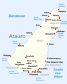
| location | Atauro , Dili Municipality , East Timor | |
| Coordinates | 8 ° 16 '10 " S , 125 ° 34' 26" E | |
|
||
| Type | volcanic, submarine origin | |
| Normal way | By walk from Anartuto from accessing | |
| particularities | Highest point on the island of Atauro | |
 Tropical mountain forest at Mano Côco |
||

The Mano Côco ( Foho Manococo , Manucoco , Manucoco ) is at 999 m the highest point on the East Timor island Atauro . It is located in the south of the island in the Suco Macadade and can be climbed without climbing.
nature
| Endemic and endangered bird species in the Mano Côco area of Timor and Wetar | |
| Bird species | information |
| Great cuckoo pigeon ( Macropygia magna ) | endemic |
| Timor pigeon ( Turacoena modesta ) | endangered / endemic |
| Green Timor Pigeon ( Treron psittaceus ) | threatened / endemic |
| Pink-headed fruit pigeon ( Ducula rosacea ) | low risk |
| Yellow-headed Lorikeet ( Trichoglossus euteles ) | endemic |
| Timorgerygone ( Gerygone inornata ) | endemic |
| Orpheus thick head ( Pachycephala orpheus ) | endemic |
| Sundapirol ( Oriolus melanotis ) | endemic |
| Timorese tail ( Urosphena subulata ) | endemic |
| Timor Warrior ( Phylloscopus presbytes ) | endemic |
| Timor Thrush ( Zoothera peronii ) | endangered / endemic |
| Macklot mistletoe ( Dicaeum maugei ) | endemic |
| Sun nectar bird ( Cinnyris solaris ) | endemic |
| Blue-green parrot finch ( Erythrura tricolor ) | unsure |
The mountain is of volcanic, submarine origin.
The wooded area is a nature reserve and part of the island-wide Important Bird Area with an area of 14,118 hectares. Agriculture is practiced up to a height of 600 m . More than 700 m there are still stocks of tropical forest, especially in the protected valleys. However, the search for firewood endangers the forest. The reserve can be reached via footpaths from Anartuto . You can only get there by off-road vehicle over a road from the coastal town of Beloi .
The Mano Côco is located in the south of the island

Tropical forest covers the slopes of Mano Côco


See also
Web links
Individual evidence
- ^ University of Coimbra, Portugal, East Timor, The geomorfology
- ↑ UNTAET Reulation No. 2000/19 - On protected places ( Memento from October 18, 2000 in the Internet Archive ) (PDF file; 39 kB)
- ↑ Birdlife Data Zone: Important Bird Area TL04 Atauro Island-Manucoco