Legumau
| Legumau | ||
|---|---|---|
|
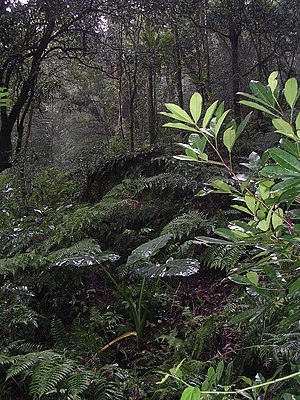
Tropical mountain forest at an altitude of 1100 m on the Legumau |
||
| height | 1221 m | |
| location | Suco Lacawa , Luro Administrative Office , Lautém Municipality , East Timor | |
| Coordinates | 8 ° 34'0 " S , 126 ° 47'2" E | |
|
|
||
The Legumau (also Legumaw , Laqumau or Monte Apara ) has a height of 1221 m , 1228 m , 1263 m or 1297 m depending on the source . This makes it the highest mountain in the East Timorese community of Lautém . It is located in its administrative office in Luro , in the south of Suco Lacawa , near the border with the municipality of Baucau .
In 1978 the mountain was a base of the FALINTIL , the resistance movement against the Indonesian occupation (1975-1999). It was not abandoned until June 1978 when the Indonesian armed forces advanced from Uatucarbau . The East Timorese moved on to Lavateri and finally to Matebian .
Web links
Commons : Legumau - collection of images, videos and audio files
See also
Individual evidence
- ↑ geonames
- ^ Ministry of Defense and Security - Biography of Commander F-FDTL ( Memento from July 25, 2008 in the Internet Archive )
- ↑ "Chapter 7.3 Forced Displacement and Famine" (PDF; 1.3 MB) from the "Chega!" Report of the CAVR (English)

