
Fuiloro plateau

The Fuiloro Plateau ( Portuguese Planalto de Fuiloro ) in the municipality of Lautém is the most striking plateau in East Timor . It extends over an area of 440 km² the north of the administrative office of Lospalos and the west of Tutuala in the far east of the country.
To the south, the plateau drops imperceptibly due to its large area from a height of 700 m to 500 m until it meets the Paitchau mountain range . Originally the plateau was the lagoon of a primeval atoll .
The plateau forms a large polje between two mountain ranges, with an area of 100 km². A total of 406 km² is only drained within the plateau. To the east is the country's largest lake, the Ira Lalaro . It flows over the Irasiquero , which disappears into the Mainina hole , a ponor . Color tests have shown that the water reappears in three springs south of the mountains as well as in four springs near Com , on the north coast.
The plateau is home to numerous species of birds and, with its eastern part, belongs to the Nino Konis Santana National Park . The southern slopes were covered with rainforests until the 1950s , but today there is only secondary forest here .

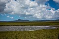
View of the Fuiloro Plateau from the radio tower on Monte Laleno to the north-west .

East of Lospalos
View of the Paitchau

Near the Ira Lalaro


Individual evidence
- ↑ Colin Trainor: The ant fauna of Timor and neighboring islands: potential bridges between the disjunct faunas of South East Asia and Australia , Australian Journal of Zoology, 2010, 58, 133-144
- ^ University of Coimbra - The geomorfology of Timor-Leste ( Memento of December 9, 2007 in the Internet Archive )
- ↑ a b Report of Findings on the Proposed Iralalaro Hydro-ElectricPower Scheme, Timor-Leste (pdf; 3.2 MB) Haburas Foundation and the Australian Conservation Foundation. Retrieved August 9, 2013.
- ↑ M. Freire, P. Pinto, M. Soares, S. Medeiros, ASPS Reboleira, A. Reis, M. Gomez: Fatuk-Kuak Hosi Timor Lorosa'e: Caves of Timor-Leste , Proceedings of the 17th International Congress of Speleplogy, 2017, accessed January 1, 2020.
- ^ Colin R. Trainor: Waterbirds and coastal seabirds of Timor-Leste (East Timor): status and distribution from surveys in August 2002-December 2004
- ↑ WWF: Timor and Wetar deciduous forests (AA0204)
Coordinates: 8 ° 32 ′ 32 ″ S , 126 ° 57 ′ 5 ″ E