
Taimyr Lake
| Taimyr Lake | ||
|---|---|---|

|
||
| Location of Lake Taimyr on the Taimyr Peninsula | ||
| Geographical location | Krasnoyarsk Region ( Russia ) | |
| Tributaries |
Upper Taimyra (main tributary); Bikada-Nguoma , Chernyye Yary , Jamutarida , Kalamissamo , Ledjanaja , Olenja , Sapadnaja , Severnaya , Ugolnaja |
|
| Drain | Lower Taimyra | |
| Islands | 20th | |
| Location close to the shore | Chatanga | |
| Data | ||
| Coordinates | 74 ° 33 ' N , 101 ° 39' E | |
|
||
| Altitude above sea level | 6 m | |
| surface | 4th 560 km² | |
| length | 165 km | |
| width | 135 km | |
| volume | 12.8 km³ | |
| Maximum depth | 26 m | |
| Middle deep | 2.8 m | |
| Catchment area | 104,300 km² | |
|
particularities |
||

The Taimyrsee ( Russian Таймырское озеро / Taimyrskoje osero ) is an approximately 4,560 km² large lake on the Taimyra in northern Russia on the north Siberian Taimyr peninsula in the northern part of the Krasnoyarsk region . Apart from the Eurasian Caspian Sea, it is the second largest lake in the Asian part of Russia after Lake Baikal .
geography
Geographical location
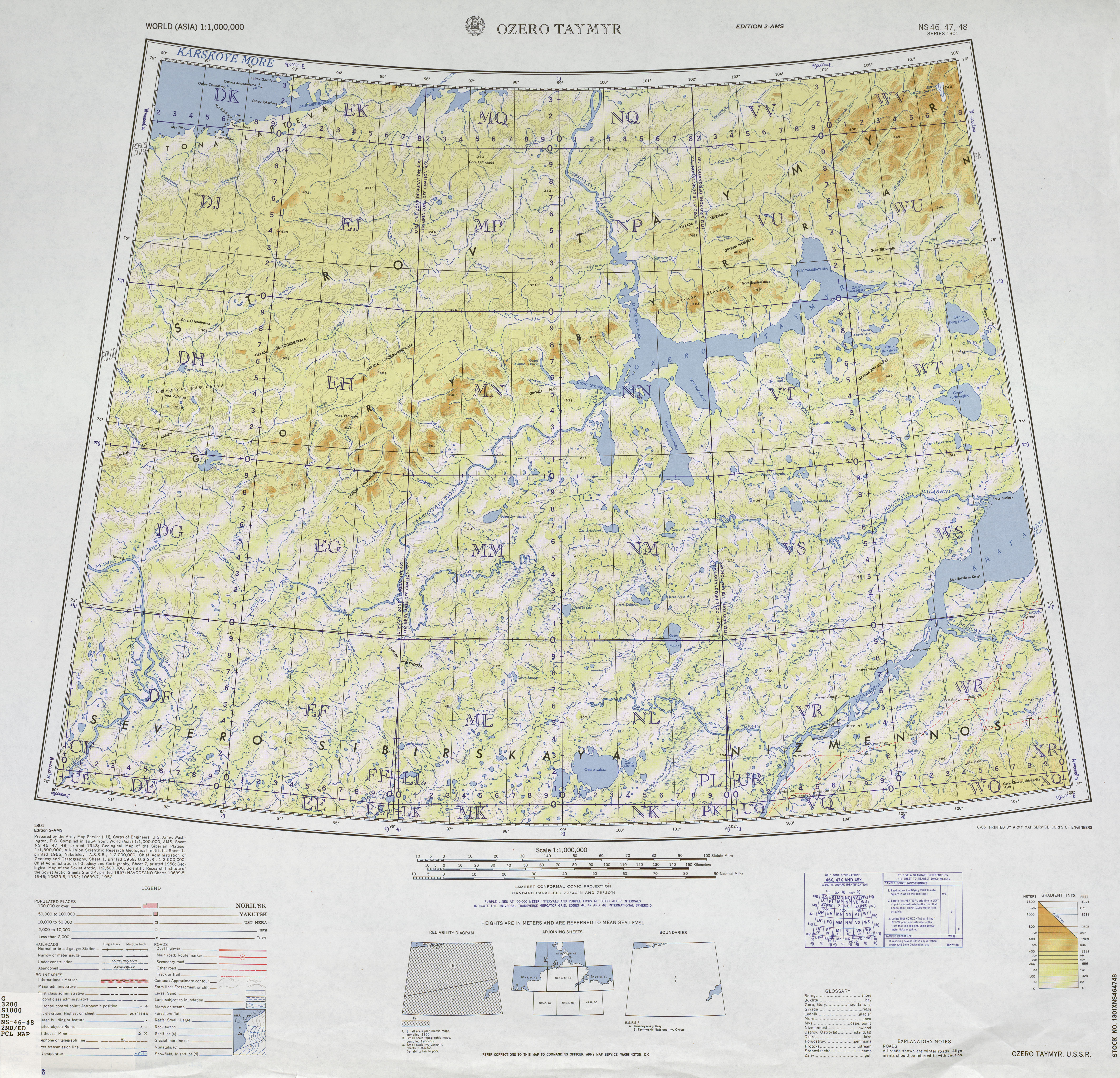
The Taimyrsee is located almost 900 km beyond or north of the Arctic Circle in the northern part of the Taimyr Depression on the southern edge of the Byrranga Mountains , up to 1125 m high , with its northwestern arm piercing the mountains towards the north. As part of the tundra , it is surrounded by mountains that are up to 663 m high north of the lake . It is traversed by the approximately 640 km long Taimyra , which flows into the lake as Upper Taimyra from the southwest and leaves it as Lower Taimyra in a north-northwest direction, flows through the Byrranga Mountains northwards and flows into the eastern part of the Kara Sea. There are no settlements on the bank, but the village of Chatanga lies around 210 km south of the southwest arm ( Baikuraneru ) on the Chatanga River .
The Taimyrsee borders on the five-part Taimyr Biosphere Reserve , founded as a nature reserve on February 23, 1979 , which was designated as a biosphere reserve by UNESCO in 1995 and is around 2.72 million km² in size.
Data
The approximately 4,560 km² large Taimyrsee has a volume of around 12.8 km³. The lake is about 165 km long in a west-east direction and around 135 km in a north-south direction, although it is otherwise rather narrow in comparison to these dimensions. With an average depth of around 2.8 m, it is a maximum of around 26 m deep. The lake basin, which in the ice ages of glaciers was met, with its water level to an average of about 6 m height, a crypto depression is because his base about 20 m below sea level. Its catchment area covers around 104,300 km².
Landscape image
The Taimyrsee as part of the tundra with its swamps has an irregular shape with numerous branches of the lake. While the northern shores along the Byrranga Mountains are quite steep and partly rocky, gently sloping, sandy gravel soils prevail to the south towards the Taimyr Depression. In addition to some islets, there are about 20 larger islands in the lake, many rocky ones in the western part and the sandy Sokolov-Mikitova in the eastern part .
Inflows, outflows and neighboring lakes
In addition to the Upper Taimyra as the main tributary, Lake Taimyr is fed by many rivers , including Olenja (north), Severnaya and Sapadnaja (both northeast), Bikada-Nguoma (east), Jamutarida (south), Kalamissamo (southwest), Ledjanaja (west) and Ugolnaja and Chernyye Yary (both north-west). Some of the water comes from the surrounding mountain lakes; For example, the Ledjanaja is fed by the Krasnaja , which flows through the Loewinson-Lessing Lake , located about 10 km west of the Ledjanaja Bay ( western part of the lake) . The only outflow is the Lower Taimyra .
Especially in the southwest, south and southeast, the Taimyrsee is surrounded by numerous, smaller lakes. This includes the approximately 35 km east-southeast of Jamuneru Bay (Seeostteil) lying Kungasalachsee ( ⊙ ) and about 75 km south-east of the bay located Portnjaginosee ( ⊙ ) and located near the Taymyr River influence in the Lake Taymyr Baikuraturkusee ( ⊙ ), all are quite large.
Climate, ice drift and hydrology
The average temperature of the Taimyrsee water is 0 to 1 ° C in winter and 7 to 8 ° C in August, that of the air is −13.4 ° C in the coldest month and 12.3 ° C in the warmest month (July) . Every year, the Lake of the end of September to June from a 2 to 3 m thick ice layer covering. The average ice-free time is only 73 days. Despite productive winter rainfall, strong winds and flat terrain prevent the formation of a significant snow cover on the ice of the lake and in the permafrost of the tundra . The storms, which are frequent in summer, cause the water to become extremely cloudy due to the shallow depth of the lake. The water level at an average height of around 6 m above sea level experiences a seasonal decrease to only 1.5 m , with the lake area shrinking to only 1,200 km²; Therefore the Taimyrsee plays a regulatory role for the water balance of the Lower Taimyra , whereby the backwater caused by the ice level restricts the lake water flow for a long time. At the beginning of summer, the water level begins to rise again, which continues into August.
Flora and fauna
The Taimyrsee has no species-rich flora, which is why the food chain of aquatic animals is based on phytoplankton . But it is teeming with fish species typical of Arctic waters, such as carp , salmon fish (such as trout , salmon , vendace and omule ) and lavaret . Despite the remoteness of the region, some fish species are overexploited . Red-necked geese and other goose birds nest on the lake islands .
environmental pollution
Slight levels of plutonium were found in the sediments of Lake Taymyr . This is perhaps a consequence of the many atmospheric nuclear tests carried out over Novaya Zemlya by the Soviet Union during the Cold War , with particles being carried out to sea by wind.
Individual evidence
- ↑ a b c d e f g h i Article Taimyrsee in the Great Soviet Encyclopedia (BSE) , 3rd edition 1969–1978 (Russian)
- ↑ a b c d Distance measured on US military map (1964)
- ↑ a b c d e f g h i j k l Taimyrsee (Russian Wikipedia)
- ↑ Topographic map (1: 1,000,000, sheet S-47,48, 1986 edition), Taimyrsee (center) and a. with the Byrranga Mountains (running diagonally) intersecting Taimyra (flowing from the lake to the north) and the Chatanga (diagonal, bottom right), on maps47.narod.ru (with heights above sea level )
- ↑ a b Russian-German cooperation: The TAYMYR expedition 1994 (Siegert, Bolshiyanov; see in the literature section )
- ↑ a b Taimyrsee (English Wikipedia)
literature
- Russian-German Cooperation: The Expedition TAYMYR 1994 . In: Christine Siegert, Dmitry Bolshiyanov (ed.): Reports on polar research . tape 175 , 1995, ISSN 0176-5027 ( PDF , English).
photos

Catchment area of the Taimyrsee

Taimyrsee with Byrranga Mountains and Taimyra ( US military ; 1964)

