
Rishiri (mountain)
| Rishiri | ||
|---|---|---|
 The Rishiri in the winter of 2004 |
||
| height | 1721 m | |
| location | Rishiri Island , Japan | |
| Coordinates | 45 ° 11 ′ 0 ″ N , 141 ° 15 ′ 0 ″ E | |
|
||
| Type | inactive stratovolcano | |
| Last eruption | 5830 BC Chr. ± 300 years | |

.jpg)
The Rishiri ( Japanese 利 尻 山 , -zan ) is located off the Japanese island of Hokkaidō in the Sea of Japan . Its last eruption is dated to 5830 BC. Dated ± 300 years BC.
The inactive andesitic stratovolcano rises 1721 m from the sea and with its cone forms the island of Rishiri with a diameter of 20 km. Volcanic activity in the area of the volcano began less than 200,000 years ago. The eruptions in the central crater ended 37,000 years ago. After that, only the side craters were still active, mainly basaltic lava being extracted.
Because of its cone shape reminiscent of Mount Fuji , it is sometimes referred to as Rishiri Fuji . On a clear day you can see the Russian island of Sakhalin from its summit .
gallery

The Rishiri from Oshidomari Port
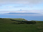
Rishiri Island from Rebun
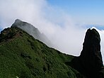
Rishiri summit area


Web links
- Rishiri in the Global Volcanism Program of the Smithsonian Institution (English)