Rishiri (island)
| Rishiri | ||
|---|---|---|
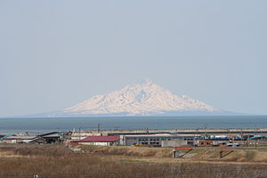
| Rishiri as seen from Embetsu on the mainland | ||
| Waters | Japanese sea | |
| Geographical location | 45 ° 11 ′ N , 141 ° 15 ′ E | |
|
|
||
| length | 18.2 km | |
| width | 14.6 km | |
| surface | 182.09 km² | |
| Highest elevation | Rishiri volcano 1721 m |
|
| Residents | 5593 (December 31, 2008) 31 inhabitants / km² |
|
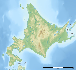
| Rishiri relief | ||
The island of Rishiri ( Japanese 利 尻 島 , Rishiri-tō ) rises from the Sea of Japan off the coast of Hokkaidō from the sea. The island is formed by the conical peak of the inactive Rishiri volcano . Together with the island of Rebun and the coastal area of Sarobetsu , the island belongs to the Rishiri-Rebun-Sarobetsu National Park .
The main industries on the island are tourism and fishing. The island has a circumference of 63 km and an area of 182.09 km².
etymology
The name Rishiri comes from Ainu rii-shiri , which means "high island".
Attractions
- Cape Peshi on the east side of Washidomari Port
- Cape Senhoshi
- Neguma (Sleeping Bear) Rock
- Jimmen Rock
- Ponmoshiri Island
- Hime March
- Menūshoro March
- Otatomari March
Communities
The island and its municipalities are part of the district Rishiri the sub-prefecture SOYA of Hokkaido Prefecture .
The county consists of the cities of Rishiri and Rishirifuji .
These cities include the following districts, listed clockwise from the north of the island:
- Oshidomari
- Himenuma
- Oniwaki
- Numaura
- Misaki
- Senposhi
- Cusurs
- Randomari
- Kutsugata
- Shinminato
- Motodomari
transport
- Ferries run to Rebun , Wakkanai and Otaru
- There is a flight connection to Wakkanai
- A bus runs on a ring traffic around the island.
history
Ranald MacDonald landed on Rishiri in 1848.
Individual evidence
- ↑ 島 面積 . (PDF; 136 kB) (No longer available online.) Kokudo Chiriin , October 1, 2015, archived from the original on June 15, 2016 ; Retrieved July 30, 2016 (Japanese). Info: The archive link was inserted automatically and has not yet been checked. Please check the original and archive link according to the instructions and then remove this notice.
- ↑ 利 尻 の ア イ ヌ 語 地名 (Eng. "Ainu place names of Rishiri"). (PDF; 1.1 MB) Rishirifuji City Education Committee, accessed July 30, 2016 (Japanese).


