Olkhon
| Olkhon | ||
|---|---|---|
| View from the island of Olkhon to Lake Baikal | ||
| Waters | Baikal lake | |
| Geographical location | 53 ° 9 ' N , 107 ° 23' E | |
|
|
||
| length | 72 km | |
| width | 13.7 km | |
| surface | 730 km² | |
| Highest elevation | Schima 1274 m |
|
| Residents | about 1500 2.1 inhabitants / km² |
|
| main place | Khushir | |
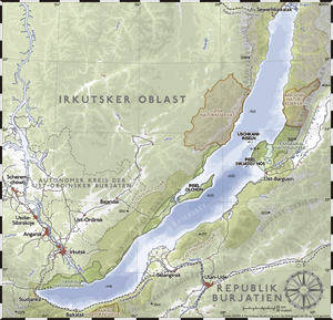
| Map of Lake Baikal | ||
Olkhon ( Russian : Ольхон , also: Ol'chon ) is an island located on the west side of Lake Baikal .
geography
With an area of 730 km², a length of 72 km and an average width of 10 km (maximum width 13.7 km), Olkhon is the largest island in Lake Baikal. The island's mountains are formed from archaic gneisses , granites , quartzites and marble and reach a height of 1274 meters in the northeast (Mount Schima). Strong north-westerly winds , called Sarma here, are characteristic of the island .
The island belongs to the settlement area of the Buryats , but administratively today it belongs to the Olkhonsky Rajon of Irkutsk Oblast with its seat in the village of Jelanzy, 40 km from the southern end of the island on the mainland . The name Ol'chon also comes from the Buryat . The exact translation is not known, sometimes the name is translated as "wood", but sometimes also as "dry" or "arid". Both translations have their justification, because the island is extremely scenic and varied. The southwest of the island is covered by larch forests, while the northeast is dominated by the foothills of the Tageran steppe. The main town of the island, Khushir , is located on the west coast in the middle of the island.
The one to two kilometer wide sea road from Olkhon separates the island from the western shore of the lake. Immediately north of the northern cape of the island ( Cape Choboi ) at latitude 53 ° 30 ′ (exact east-west direction) is the widest part of Lake Baikal, at 95.9 kilometers. There, the bay west of Olkhon, the “Little Sea” (Russian Малое море ) and the open Lake Baikal, the “Big Sea” ( Большое море ) unite , while the Svyatoi Nos (Holy Nose) peninsula on the eastern shore of the lake is only further north stands out. Northeast of the island of Olkhon is the deepest point of Lake Baikal.
population
Almost 1700 people live on Olkhon (as of 2014), most of whom are of Buryat origin. The nine villages on the island together form the municipality (gorodskoje posselenije) Kushirskoje with its seat in the urban-type settlement Kushir, where the overwhelming majority of the island's population lives with 1350 inhabitants. The other places are the villages ( derevnja ) Chadai (3 permanent residents), Chalgai (46), Kharanzy (97), Jalga (90) and Maly Khushir (60), the settlements Pestschanaja (8) and at the research station Usury (9 ) as well as the court (saimka) Ussyk (3, all data according to 2010 census).
The main source of food is fish , primarily the omul , which is prepared in every imaginable form on the island.
Infrastructure
Olkhon was only connected to the power grid in 2005, before electricity could only be generated with (diesel) generators. At the same time, a cellular antenna was also set up. However, there is still no running water (as of March 2017). The residents get their supplies directly from Lake Baikal, whose water is of drinking water quality. The former fish factory in Khushir has been closed. There is regular ferry service to the southeast end of the island.
Sightseeing and tourism
The most famous sights of Olkhon are the holy shaman rock ( скала Шаманка , Skala Shamanka ) not far north of Khushir, which is considered a sacred place of the Buryats and was formerly used for shaman rituals . In the further course to the north, the island offers some spectacular cliffs that stretch to the northern Cape Choboi. There are no more paved roads north of Khushir. This part of the island is therefore only accessible with off-road vehicles, which are available for tourists with a driver.
In the last decade, Olkhon has experienced a steadily increasing influx of tourism due to its diverse landscape and relative isolation, which has made this branch of the economy considerably more important for the population and economic life.
The place became known to the general public in Germany primarily through the ZDF documentary “Sternflüstern: Das Sibirienabventure” (2004), in which two German families tried to live there like the locals for five months.
Web links
- Spiegel report
- Eduard Y. Osipov., Oleg M. Khlystov. Glaciers and meltwater flux to Lake Baikal during the Last Glacial Maximum // Palaeogeography, Palaeoclimatology, Palaeoecology 294 (2010) 4-15.
Individual evidence
- ↑ Olkhon Iceland . Retrieved October 22, 2006.


