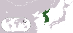
Korean peninsula
|
Korean Peninsula 한반도 (Hanbando) |
|
 Satellite image of the Korean Peninsula |
|
| Geographical location | |
| Coordinates | 38 ° N , 127 ° E |
| location | south of the People's Republic of China |
| Waters 1 | Yellow sea (west) |
| Waters 2 | East Sea (east) |
| length | around 560 km |
| width | Max. 320 km |
| surface | 221,154 km² |
 Map of the Korean Peninsula |
|
The Korean Peninsula is a peninsula in East Asia . In North Korea it is called Chosŏn Pando ( kor. 조선 반도 , 朝鮮 半島 ), in South Korea Han Bando ( 한반도 , 韓 半島 ).
geography
The peninsula is bounded to the east by the East Sea , to the south by the Korea Strait and to the west by the Yellow Sea . In the north, the geographical boundary is assigned to the Yalu and Tuman-gang rivers . This corresponds to the exact border between North Korea and Russia and the People's Republic of China .
The north-south extension of the peninsula is about 1100 km, the east-west extension in the southern half is about 300 km. The area corresponds to about 221,154 km 2 .
climate
The Korean Peninsula is located in the temperate climate zone . There are four seasons of spring , summer , autumn and winter . The climate on the peninsula has both typically continental and oceanic characteristics.
Summer on the peninsula lasts approximately from mid-June to mid-September. In the months of June and July is the rainy season, also called monsoon season or Jangma , which is characterized by heavy rainfall. Due to the maritime air masses that bring with them moist air from the Philippines , parts of the southern half of Korea have a monsoon climate at this time .
Autumn begins in September. The weather is predominantly mild and sunny, which is only sometimes stopped by the ingress of cold air.
Winter begins in December. The winter monsoon has a firm grip on the north, while the south is characterized by a constant change from frosty to milder weather. So there is a strong climatic contrast between the north and the south. You can see this from the average temperatures. In Busan it is +6 ° C, and on the border with the People's Republic of China sometimes down to −19 ° C.
Winter generally ends at the end of March, when the south wind brings in warmer air over the peninsula.
Political structure
There are two states on the peninsula: the Democratic People's Republic of Korea in the northern part and the Republic of Korea in the southern part. The border line between the two has been running roughly along the 38th parallel since 1953.
References and footnotes
- ↑ Conrad Philipp: The importance of a green belt for a megacity - Interdisciplinary urban analysis using the example of Seoul (Republic of Korea) , dissertation, University of Duisburg-Essen, Faculty of Humanities, October 18, 2013, p. 16, accessed on December 12, 2014
- ^ Climate of Korea. In: Korea Meteorological Administration. Retrieved May 24, 2020 .
