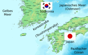
Korea Street
| Korea Street | ||
|---|---|---|
| Map with the location of Koreastrasse | ||
| Connects waters | Japanese sea | |
| with water | East China Sea | |
| Separates land mass | Korean peninsula | |
| of land mass | Kyushu , Honshu | |
| Data | ||
| Geographical location | 34 ° 36 ' N , 129 ° 48' E | |
|
|
||
| Smallest width | 200 km | |
| Greatest depth | 227 m | |
| Coastal towns | Pusan , Fukuoka | |
| Islands | Tsushima , Iki , Jejudo | |
| Korea Street | |
|---|---|
| Japanese name | |
| Kanji | 対 馬 海峡 |
| Hepburn | Tsushima Kaikyō |
| South Korean name | |
| Hangeul | 대한 해협 |
| Hanja | 大 韓 海峽 |
| Revised | Daehan Haehyeop |
| McCune-Reischauer | Taehan Haehyŏp |
The Korea Strait (rarely Strait of Korea or Tsushima strait is called) a sea passage between the East China Sea to the southwest and the Sea of Japan in the northeast. The Korean Strait is bounded in the north by the Korean Peninsula and in the south by the Japanese islands of Kyūshū and Honshū .
The passage is about 90 meters deep and is divided by the Tsushima Islands .
Naming
Koreastrasse is sometimes also called Krusenstern-Strasse after Adam Johann von Krusenstern , the first circumnavigator in Russian service.
The eastern part (or the southeastern passage) is often also called Tsushima Street , the western part (or northwestern passage) was once known as Chōsen Street and is now also known as the Strait of Korea . Another classification calls the entire Korea Street Tsushima Street .
Ocean current
An offshoot of the Kuroshio ( Japanstrom ) passes the Koreastrasse to the northeast. The warm arm of the current is called the Tsushima Current and is native to the Japanese Islands. The river eventually flows into the Pacific , more precisely into the Sea of Okhotsk near Sakhalin .
history
In May 1905, during the Russo-Japanese War , the sea battle at Tsushima took place in the Korea Strait . In the decisive battle, the Imperial Japanese Navy defeated the Second Pacific Squadron of the Imperial Russian Navy .

