
Guilin
| Guìlín Shì 桂林市 Guilin |
|||
|---|---|---|---|

|
|||
|
|||
| Coordinates | 25 ° 14 ′ N , 110 ° 11 ′ E | ||
 Guilin in Guangxi |
|||
| Basic data | |||
| Country | People's Republic of China | ||
| region | South china | ||
| Autonomous area | Guangxi | ||
| ISO 3166-2 | CN-GX | ||
| status | District-free city | ||
| structure | 6 city districts, 8 districts, 2 autonomous districts, one urban district | ||
| height | 153 m | ||
| surface | 27,797 km² | ||
| Residents | 963,629 (2010) | ||
| Metropolitan area | 5,010,000 (2016) | ||
| density | 34.7 Ew. / km² | ||
| Post Code | 541000 - 541999 | ||
| Telephone code | (+86) 773 | ||
| Time zone | China Standard Time (CST) UTC +8 |
||
| License Plate | 桂 C | ||
| Website | www.guilin.gov.cn (Chinese) | ||

Guilin ( Chinese 桂林市 , Pinyin Guìlín Shì ; Zhuang Gveilinz Si ; obsolete Post : Kweilin, short: 桂 , Guì ) is a district-free city in the People's Republic of China .
Guilin is located in the northeast of the Guangxi Autonomous Region of the Zhuang Nationality in southeast China on the banks of the Li Jiang (Li River). The Chinese characters of the name Guilin mean "City of the Scented Blossom Forest "; the name refers to the large number of osmanthus trees in the city. The city is built in an impressive landscape between hills.
Administrative structure
The city of Guilin is made up of six urban districts , eight counties , two autonomous counties and one urban district. These are:
- Xiangshan district (象 山区), 88 km², approx. 210,000 inhabitants, postcode 541002, seat of the city government until January 17, 2013;
- Diecai district (叠彩 区), 52 km², approx. 130,000 inhabitants, zip code 541001;
- Xiufeng district (秀峰 区), 49 km², approx. 110,000 inhabitants, postcode 541001;
- District Qixing (七星 区), 74 km², approx. 200,000 inhabitants, postcode 541004;
- Yanshan district (雁 山区), 288 km², approx. 70,000 inhabitants, zip code 541006;
- City district Lingui (临桂 区), 2,202 km², approx. 450,000 inhabitants, postcode 541100, seat of the city government since January 18, 2013;
- Yangshuo County (阳朔 县), 1,428 km², approx. 300,000 inhabitants, administrative center: Yangshuo Township (阳朔 镇), zip code 541900;
- District Lingchuan (灵川县), 2,288 km², about 350,000 inhabitants, administrative center: greater community Lingchuan (灵川镇), postal code 541200;
- Quanzhou County (全州县), 4,021 km², approx. 770,000 inhabitants, administrative center: Quanzhou Township (全 州镇), zip code 541500;
- Xing'an district (兴安 县), 2,345 km², approx. 370,000 inhabitants, administrative seat: Xing'an municipality (兴安 镇), zip code 541300;
- Yongfu County (永福 县), 2,807 km², approx. 270,000 inhabitants, administrative center: Yongfu Township (永福 镇), zip code 541800;
- Circle Guanyang (灌阳县), 1,837 km², about 270,000 inhabitants, administrative center: Large village Guanyang (灌阳镇), postal code 541600;
- Ziyuan County (资源 县), 1,954 km², approx. 170,000 inhabitants, administrative seat: Ziyuan Municipality (资源 镇), zip code 541400;
- Pingle district (平 乐 县), 1,919 km², approx. 430,000 inhabitants, administrative center: Pingle municipality (平 乐 镇), zip code 541400;
- Longsheng Autonomous County of several nationalities (龙胜 各族 自治县), 2,537 km², approx. 170,000 inhabitants, administrative center: Longsheng Municipality (龙胜 镇), zip code 541700;
- Gongcheng Autonomous County of the Yao (恭城 瑶族 自治县), 2,149 km², approx. 280,000 inhabitants, administrative center: Gongcheng Municipality (恭 城镇), zip code 5415400;
- City of Lipu (荔浦 市), 1,759 km², approx. 370,000 inhabitants, administrative seat: Licheng municipality (荔 城镇), zip code 546600.
Ethnic breakdown of the population of Guilin (2000)
The 2000 census in Guilin counted 4,614,670 residents of the greater municipality. In the 2010 census, the urban population was 963,629.
| Name of the people | Residents | proportion of |
|---|---|---|
| Han | 3,887,657 | 84.25% |
| Yao | 375.902 | 8.15% |
| Zhuang | 216,950 | 4.7% |
| Miao | 58,951 | 1.28% |
| Dong | 48.166 | 1.04% |
| Hui | 17,550 | 0.38% |
| Manju | 1,805 | 0.04% |
| Mulam | 1,585 | 0.03% |
| Mongols | 1,190 | 0.03% |
| Others | 4,914 | 0.11% |
history

The landscape around Guilin was created when the primal Mediterranean Sea receded 200 million years ago due to tectonic elevations of the sea floor and the remaining mountains slowly eroded.
The history of Guilin can be traced back about 2,100 years. In the sources, the region is first mentioned in the Qin Dynasty . In order to ensure the supply of the troops, Qin Shihuangdi had a canal built from the Yangtze River to the Guilin area. The 34-kilometer Lingqu Canal connected the Xiang River with the Li River .
An administrative unit on the site of today's Guilin is first established in 111 BC. BC (year 6 of the reign of Emperor Wu of the Han Dynasty ), then as Shi County.
From the Song to the Qing dynasties , Guilin was the cultural center of Guangxi .
After the Ming was overthrown by the Manchu , the Ming pretender Zhu Youlang ( 朱 由 榔 ) settled in Guilin as Yongli Emperor ( 永曆 , Emperor of Perpetual Experience) of the southern Ming dynasty, before moving to Burma with his court escaped.
In 1914 the seat of the provincial government was moved from Guilin to Nanning . 1936, which drew Kuomintang -regierung the Republic of China under Chiang Kai-shek after the conquest of Nanjing by the Empire of Japan to Guilin back. Until 1938, the city was the seat of government in China. The population swelled to around one million people. In 1938, while fleeing from the Japanese troops, the government moved to Chongqing, further north-west . In 1944 the Japanese were able to conquer Guilin after the old buildings had been almost completely destroyed by bombing.
Panoramic photo

education
Guilin has several colleges, including the Guangxi Normal University, originally a teacher training college, the Guilin Medical Academy as a medical college and several special universities, u. a. the Guilin Institute of Tourism, a military academy and the Guilin Electrotechnical University, which is comparable to a technical college .
tourism

Guilin is a popular holiday destination in China because of its karst mountains and countless grottos. Here, next to the Li River, several branches, tributaries and canals meander through the city, which is surrounded by a whole belt of mountains with bizarre rock formations.
The small town of Yangshuo is located about 50 km south , to which river trips are offered from Guilin on special ships with very shallow drafts. In the main travel season, up to around 10,000 tourists make the four-hour journey every day (as of 2007). The drive and the surroundings of Yangshuo offer a similar mountain landscape as Guilin itself, which is, however, even more impressive. It is also possible to take the bus to Yangshuo and from there take a shortened river trip (approx. 2 hours). Here the most interesting areas are approached by ship.
Attractions

Reed
Flute Cave 蘆笛岩 / 芦笛岩
Lúdíyán
Elephant
Trunk
Hill 象鼻山 Xiàngbíshān
Peak of Unique Beauty
獨秀峰 / 独秀峰
Dúxiùfēng
Cave of the Seven Stars
七星岩
Qīxīngyán
Mount Fubo
伏波山
Fúbōshān
City of the Prince of Jingjiang
靖江 王 城
Jìngjiāng Wángchéng
Panorama of the rice terraces at Longsheng
龍勝 梯田 / 龙胜
梯田 Lóngshèng Tītián


Reed Flute Cave
The largest and most impressive cave in Guilin is the Reed Flute Cave ( 蘆笛岩 / 芦笛岩 , Lúdíyán ), which is located in the Mountain of Light northwest of the city. It takes its name from the reed that grows at the entrance to the cave and can be used to make flutes. In the 240 m deep stalactite cave, the visitor makes his 500 m long way through a sea of stalactites and stalagmites. A grotto called "The Dragon King's Crystal Palace " holds 1,000 people. The colored lighting is impressive, but it also promotes the growth of moss and algae.
Elephant Trunk Hill
The Elephant Trunk Hill ( 象鼻山 , Xiàngbíshān ) stands at the confluence of the Yangjiang and Li Jiang. It resembles an elephant drinking water and is the symbol of the city of Guilin. There is a pagoda in the front part of the elephant trunk. According to a legend, an elephant was stabbed to death while drinking water (by the pagoda).
Peak of unique beauty
The Peak of Unique Beauty ( 獨秀峰 / 独秀峰 , Dúxiùfēng ) is located in the middle of the city on the campus of the Guangxi University of Education. From the top you have a panoramic view over the Li River and the surrounding mountains.
Seven Stars Park
The Park of the Seven Stars ( 七星 公園 / 七星 公园 , Qīxīng Gōngyuán ) is located in the city of Guilin. It takes its name from the seven mountains that resemble the constellation of the Great Bear. In the park there is a small zoo, flower beds and play facilities for children. There is also a stalactite cave to visit here. As an extraordinary attraction the Camel Mountain ( 駱駝 山 / 骆驼 山 , Luòtuoshān ) - a rock grouping in the shape of a camel.
Mountain of colored layers
The rock layers of the mountain of colored layers ( 疊彩 山 / 叠彩 山 , Diécǎishān ) are reminiscent of a pile of different colored silk ribbons.
Fuboshan
Mount Fubo ( 伏波山 , Fúbōshān ) is a single peak that rises suddenly from the plain. It protrudes into the Li River and blocks the waves. Fubo is the name of a general of the Han Dynasty who once visited this mountain. But Fubo also means: “block the waves” .
Landscape of the Li River

The Li River ( Lijiang ) has its source at Katzenberg in northeast Guangxi and flows through Guilin. The scenic 40 km long route between Guilin and Yangshuo is used by numerous tourist ships. Directly on the river between the two cities, there is a larger cave ( Crown Cave ) to be admired. Most of the tourist ships stop here to allow tourists to tour the cave. The cave is characterized by its size and its variety of stalactites. Among other things, part of the cave is accessed by boat. Native cormorant fishermen can be seen on the Li River in the Yangshuo area .
Ming Royal Tombs
In the northeast of the city there are royal tombs from the Ming period .
The associated buildings and structures in the city of the Prince of Jingjiang ( 靖江 王 城 , Jìngjiāng Wángchéng ) are quite well preserved and hardly ever used by tourism.
Longsheng rice terraces
About 100 km away from the city of Guilin are the rice terraces of Longsheng in an area predominantly inhabited by the Yao minority .
Other inner city sights and attractions
Zhongshanlu
The Zhongshanlu ( 中 山路 , Zhōngshānlù - "Sun Yatsen Street") is the shopping street of Guilin. In addition to department stores, there are also several shops and boutiques. In the evening, some side streets of Zhongshanlu are closed to traffic. Here, souvenirs, clothing and other items such as toys or fruit and vegetables are offered at market stalls.
There is a large square with an open-air stage right on Zhongshanlu. Here in the summer there are often performances but also open-air exhibitions. Right next to it is the Lijiang Waterfall Hotel, where you can occasionally admire the play of light and the waterfall coming down from the hotel roof.
Picture gallery
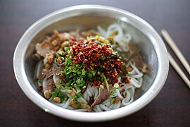
Guilin style rice noodles
桂林 米粉
Guìlín Mǐfěn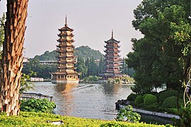
Pagodas at Shanhu Lake
杉 湖 雙塔 / 杉 湖 双塔
Shānhú Shuāngtǎ
Shanhu Lake at night
杉 湖 夜景
Shānhú Yèjǐng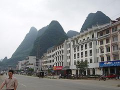
Street district near Yangshuo
陽朔 縣 街區 / 阳朔 县 街区
Yángshuòxiàn Jiēqū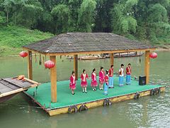
Zhuang minority
壯族 / 壮族
Zhuàngzú


Climate table
| Guilin | ||||||||||||||||||||||||||||||||||||||||||||||||
|---|---|---|---|---|---|---|---|---|---|---|---|---|---|---|---|---|---|---|---|---|---|---|---|---|---|---|---|---|---|---|---|---|---|---|---|---|---|---|---|---|---|---|---|---|---|---|---|---|
| Climate diagram | ||||||||||||||||||||||||||||||||||||||||||||||||
| ||||||||||||||||||||||||||||||||||||||||||||||||
|
Average monthly temperatures and rainfall for Guilin
|
|||||||||||||||||||||||||||||||||||||||||||||||||||||||||||||||||||||||||||||||||||||||||||||||||||||||||
Remarks
supporting documents
- ↑ Guangxi (China): Prefectural Division, Major Cities & Counties - Population Statistics, Maps, Charts, Weather and Web Information. Retrieved March 3, 2018 .
- ↑ gxnu.edu.cn
- ↑ ( Page no longer available , search in web archives: glit.cn )
- ↑ gliet.edu.cn