Geography of Serbia
Serbia is a landlocked country on the Balkan Peninsula in the south-east of the European continent .
Limits
The country shares a border with Hungary in the north (the border runs through the Pannonian Plain ), with Romania in the northeast (partly along the Danube ), and in the southeast (partly across the Stara Planina ) it shares a border with Bulgaria . In the south the country borders (partly over the Šar Planina ) on Macedonia , in the south-west (mainly over the Prokletije Mountains ) on Albania and Montenegro . In the west Serbia borders (mainly along the Drina ) with Bosnia and Herzegovina . In the northwest, the republic shares the border (mainly along the Danube) with Croatia .
Serbia borders eight neighboring countries and thus has a very central position in Southeastern Europe like no other country in the region.
The borders of Serbia extend for a total length of 2,155 km. Of this, 252 km are in Croatia, 312 km in Bosnia and Herzegovina, 476 km in Romania, 151 km in Hungary, 318 km in Bulgaria, 145 km in Albania, 221 km in Macedonia and 203 km in Montenegro.
Natural borders of Serbia are the Danube in the northwest (to Croatia) and in the east (to Romania), the Drina in the west (to Bosnia and Herzegovina), the Stara Planina in the southeast (to Bulgaria), the Šar Planina in the south (to Macedonia) , the Peštagebirge to Montenegro and the Prokletije in the southwest (to Albania). It should be noted, however, that Kosovo, as the southwestern sub-region of the Republic of Serbia, proclaimed the independence of the territory on February 17, 2008 . 114 of the 193 member states of the United Nations recognize the Republic of Kosovo as independent. The border between central Serbia and Kosovo is currently de facto an external border.
The course of the border between Serbia and Croatia has also been controversial since the fall of Yugoslavia. The border lines with Macedonia and along the Drina with Bosnia and Herzegovina are also unclear. However, these disputed areas are relatively small and mostly uninhabited, which is why these questions are now on hold.
On the border with Romania, the Danube forms the 253 km² Djerdapsee . 163 km² of the water surface of the Djerdapse is on Serbian territory.
topography
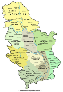
The relief of Serbia is different and varied. The north of Serbia is dominated by the wide and fertile Pannonian Plain . It is traversed by the Tisza and the Danube, which together with the Sava delimit it in the south. The only mountain range that crosses the flat Vojvodina is the Fruška Gora (511 m) in Syrmia , between the Danube and Sava. In the east is the highest point of the Pannonian Plain, the Gudurički vrh , a foothill of the Carpathian Mountains , at a height of 641 m .
To the south of the Danube-Sava line, the central Serbian hill country of the Šumadija connects . In the south of central Serbia low mountain ranges connect to the hill country. In the extreme southwest (Prokletije and Šar Planina) and in the east ( Stara Planina ) of the country, the mountain peaks reach heights of over 2000 m (sometimes over 2500 m). The highest point in Serbia, the 2656 m high Đeravica , lies in the triangle of Serbia-Montenegro-Albania. The lowest point in Serbia at 28 m above sea level is at the confluence of the Timok and the Danube (border triangle Serbia - Bulgaria - Romania ). The mountains of Serbia are criss-crossed by numerous gorges. One of them is the Iron Gate on the Danube, which separates the Carpathian Mountains in the north from the Balkan Mountains in the south.
Hydrography
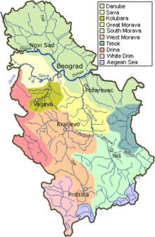
The rivers of Serbia belong to three catchment areas , each of which is tributary to the Black Sea , the Adriatic Sea and the Aegean Sea . Over 90% of the flowing waters lie in the catchment area of the Danube . Only in the southeast the Pčinja drains to the Aegean Sea and in the southwest the Beli Drim (White Drim) to the Adriatic Sea. On the Crnoljeva mountain range is the hydrographic boundary between the drainage areas of the Adriatic, Aegean and Black Sea. From the highest point of the Drmanska glava (1,367 m) the rivers run over the White Drim into the Adriatic Sea, over the Sitnica and Ibar into the Black Sea and over the tributaries of the Lepenac to the Vardar and into the Aegean Sea. Due to a hydrographic peculiarity, the Nerodimka in the catchment system of the Sitnica in Kosovo even drains into two seas through a bifurcation .
The Vojvodina plain represents the largest hydrographic node in Europe. Rivers from the Alps, Central Europe, Dinarides and Carpathians converge here. With the Drava (on the Croatian side), Tisza , Sava and Danube, all the navigable rivers of Southeast Europe meet in Vojvodina. The region, which used to be highly prone to flooding, is no longer endangered today due to the major project of the Danube-Tisza-Danube Canal and lowering of the groundwater level.
Rivers
In the north of the country the rivers of Serbia belong to the strongly meandering powerful lowland rivers of the Danube Plain , in the central, western and eastern areas to the mountain rivers of the Dinarides and Carpathians , and in Kosovo to the small lowland rivers .
Only the Sava, Tisza and Danube are continuously navigable, but also sections of the route at the mouths of the Drina and the Great Morava as well as the numerous large reservoirs.
The previously widespread rafting on the Drina and Morava has been discontinued in the 1960s.
In particular, the mountain rivers of the Dinarides, which are often made up of carbonates and especially limestone , are characterized by numerous stretches of route rich in gorges, which represent significant traffic obstacles. Even the Danube was a major obstacle to shipping until the beginning of the 20th century when the Iron Gate broke through the Carpathian Mountains through rapids and blockages in Veliki Kazan .
The flowing waters of the mountains belong to the rain and snow regimes , the Sava and Danube to the combined systems (snow, rain, glacier melt water (Danube only)). The maximum levels in the runoff are measured for the Drina and Great Morava in April, for the Danube in May.
Floods are frequent and very often catastrophic, especially on the Drina and Morava. On March 27, 1896 , the Drina reached a historical maximum discharge of over 9,000 m³ / s. Despite the numerous regulating reservoirs, the risk of flooding on the Drina is not always under control due to heavy snowmelt in its high mountain catchment area ( Prokletije , Durmitor ) and the heavy rainfall in spring. However, the Morava represents the far greater problem today. Neither protective retention basins nor significant dyke structures have been built here. Morava regulation had long been planned, but was never implemented.
The Danube and Sava have numerous retention areas on their course (e.g. Obedska bara ). The Danube and Tisza are also protected by the discharge control system of the Danube-Tisza-Danube Canal . The annual floods are therefore rarely critical today. Catastrophic Danube floods now only occur after long decades. The last major flood of 1965 turned out to be mild, as the threat to Novi Sad from the floods of agricultural land could be averted. When the Danube freezes over, the last time there was a major flood in 1956 when ice floes left the area. Several icebreakers are available for such cases.
The Danube flows through the country over a length of 588 km . In its middle section through Serbia it includes the following rivers: Theiss , Save , Tamiš , Morava , Mlava , Nera , Pek and the Timok .
The Tisza for its part receives the Begej . The Save takes on the Drina and the Kolubara . The Morava includes the Toplica, the Nišava and the Zapadna Morava . The Drina absorbs the Lim , which in turn absorbs the Uvac . The Zapadna Morava accommodates the Djetinja , Moraviaca and the Ibar , which accommodates the Sitnica .
|
Western Morava (Zapadna Morava) |
308 km (completely in Serbia) |
|
Southern Morava (Južna Morava) |
295 km (completely in Serbia) |
| Ibar | 272 km |
| Drina | 220 km (total 346 km) |
| Save (Sava) | 206 km (total 945 km) |
| Timok | 202 km (completely in Serbia) |
| Morava | 185 km (completely in Serbia) |
| Theiss (Tisa) | 168 km (total 966 km) |
| Nišava | 151 km (total 218 km) |
| Uvac | 119 km (completely in Serbia) |
| Temesch (Tamiš) | 118 km (total 359 km) |
| Kolubara | 110 km (completely in Serbia) |
Lakes
Serbia's lakes are mostly artificial. The natural lakes are very small in area. The lakes Palić (5 km²) and Ludaš in northern Serbia (near Subotica ) should be mentioned. The largest artificially created lake in Serbia is the Djerdapsee (253 km²) on the border with Romania . It is the largest lake in the country. Other reservoirs would be Lake Vlasina in the southeast, Lake Gaziva on the Ibar River , Lake Zlatar on the Uvac , and Lake Perućac and Lake Zvornik , both on the Drina , on the border with Bosnia and Herzegovina.
Other reservoirs:
- Lake Vlasina (Serbian Vlasinsko jezero ) 16 km²
- Perućacsee (Serbian Perućačko jezero ) 12.4 km²
- Gazivodeee (Serbian Gazivode jezero ) 11.9 km²
- Zvorniksee (Serbian Zvorničko jezero ) 8.1 km²
- Zlatarsee (Serbian Zlatarsko jezero ) 7.25 km²
Mountains
→ See also : List of the highest mountains and elevations in Serbia
Especially the southwest and southeast parts of Serbia are criss-crossed by mountains. These include the Dinaric Mountains , the Balkan Mountains and the Carpathian Mountains . The highest mountain is Đeravica in the Prokletije Mountains in Kosovo with an altitude of 2,656 m. If one looks at the national territory without the controversial Kosovo, the highest point is the Midžor in the Balkan Mountains directly on the Serbian-Bulgarian border.
Remarks
- ↑ The article Geography of Serbia deals with the national territory including Kosovo , which was declared independent in 2008 and which has been recognized as a state by 114 of the 193 member states represented in the United Nations.
Web links
Individual evidence
- ↑ International recognitions of the Republic of Kosovo. Republic of Kosovo, accessed June 6, 2017 .


