Geography of Montenegro
Montenegro |
Montenegro is a relatively sparsely populated mountainous country and is located in the southeast Dinarides . It has a steeply sloping coastline on the Mediterranean Sea ( Adriatic Sea ) divided by bays ( Bay of Kotor ). In particular, the barren karst region in western Montenegro ( Orjen , Lovćen ) is very sparsely populated. Only a few poljes offer some agriculturally usable land ( Grahovo , Cetinje ).
To the north and east are the highest peaks in Montenegro and the entire Dinaric Mountains . Here are the Durmitor and the Prokletije massifs , the central high mountain massifs that rise over 2500 meters.
geology

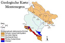
Montenegro is divided into four stratigraphic-geological zones. Over two thirds of Montenegro belong to the Karst. The tectonic units of the coast belong to the neotectonically active area, which led to catastrophic earthquakes (1556, 1666, 1979 : 7.0 on the Richter scale). The at least 4.3 kilometers thick Cretaceous and Jurassic limestones are geologically characteristic . Due to the monotony of the massive Mesozoic limestone and the high amounts of precipitation, the region is extremely karstified.
A distinct geological special status can be found in contrast to the Bay of Kotor, which is carved deep into the mountain plateau of the Orjen . At the border of two geological units, the bay was created by erosive and tectonic processes that have continued until the recent past, when a mighty Pleistocene glaciation existed in Orjen 20,000 years ago, which was caused by the melting of the huge, approx. 150 square kilometer glaciers flooding the Poljen of Grahovo led and Dragalj.
More favorable conditions prevail in the Karst where water-holding flysch facia of the Triassic, Jurassic, Cretaceous and Paleocene are located. They have been preserved as heavily eroded remains in the central part of the Bay of Kotor, where short streams are sometimes used to operate mills to this day.
geomorphology
Mountains

Montenegro is practically entirely mountainous. In the west and south, the strongly karstified coastal mountains rise abruptly to almost 2000 m from the Adriatic. To the north, the high plateaus of the Durmitors and the deeply divided slopes of the Prokletije follow. The mountain peaks in the north and east of the country consistently reach high mountain levels. The highest mountain in Montenegro is the Zla Kolata ( 2534 m. I. J. ) in the Prokletije on the Albanian border. At 2522 m. i. J. is the Bobotov Kuk in the Durmitor, the highest point within the country's borders.
The Orjen occupies a special position among the coastal mountains , as a high mountain relief has been developed here in the most intimate connection to the sea coast and the Bay of Kotor has the character of a steep canal in the heart of the High Dinarides.
The harsh climate of the Dinarides due to cold, snowy winters and the unfavorable supply situation due to the transport links leading in gorges ( Piva , Tara ) and over high mountain passes, can lead to considerable impairments in severe winters.
coast

The Montenegrin coast is located in the southeastern part of the Adriatic Sea, between Croatia and Albania. Of the 260.2 kilometers of coastline, 249.1 kilometers are on the narrow coast and 11.1 kilometers on the islands. The steeply sloping coast is separated from the interior by the limestone mountains of the hinterland ( Orjen , Lovcen, Rumija ). Only in the southern part of Montenegro has a low coastline developed from Ulcinj. The maritime climate and the tourist appreciation of the coastal towns has led to an expansion of the tourist infrastructure here since the 1960s. Important tourist centers are Herceg Novi , Tivat , Kotor , Budva and Ulcinj .
The lack of water due to the karst character leads to supply bottlenecks in summer, as some of the local freshwater sources are depleted , so that drinking water has to be imported from Bosnia ( Trebišnjica ).
The sea quickly reaches significant depths, as the deepest point of the Adriatic at 1280 meters lies directly in front of the Montenegrin coast. High summer water temperatures and nutrient deficiencies are generally characteristic of the Adriatic Sea. Fishing plays an important role locally, but is mainly concentrated in the Bay of Kotor and the mouth of the Boyana with Lake Skadar .
Waters

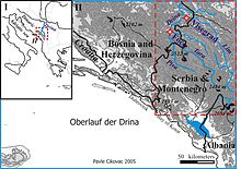
52.5% of Montenegro belong to the catchment area of the Black Sea and 47.5% of the Adriatic Sea. Only one larger river system, the Zeta-Morača system, drains to the Adriatic. The catchment area of the Drina belongs to the catchment area of the Black Sea . The largest inland body of water is Lake Skadar on the border with Albania. On its northern bank is a lowland plain, in which the capital Podgorica is located.
The catchment area of the Adriatic is about 6,560 square kilometers. These include the Morača, with its tributaries Zeta and Cijevna, Rijeka Crnojevica and Orahovstica. These three waters flow into Lake Skadar and into the Adriatic via the Boyana.
The Moraca is 113.4 kilometers long and has a catchment area of 2,628 km². The Zeta is 85 km long and has a catchment area of 1,216 square kilometers.
The catchment area of the Black Sea in Montenegro is 7,260 square kilometers and consists mainly of the upper reaches of the Drina with the tributaries of the Lim , Piva, Tara and Ćeotina .
See also: List of lakes in Montenegro
Karst
The active evolution of the karst relief depends on temperature, lithology, vegetation and the availability of water. The elevation distribution of the karst forms depends on this. The area of Montenegro is placed as a strongly developed holokarst. This appointment is based on the absence of fluvial forms. Geologically, massive limestone is a prerequisite. The pair of terms Holokarst-Merokarst laid the foundation for climatic variations in karst phenomena. Holokarst is subtropical and tropical, Merokarst is temperate (in Germany the Swabian Alb ).
Jovan Cvijić sees the Montenegrin-Herzegovinian high karst as the most developed karst in Europe: “There is no deeper and more developed karst than this Herzegovinian-Montenegrin karst between the lower Neretva, Lake Skadar and the Adriatic Sea. Not a drop of water runs off the surface, everything sinks into chimneys, ponors, crevices and depressions. "
Strong tectonic movements combined with extreme karstification have also destroyed the only original large drainage system in the Montenegrin Holokarst, the Bokeljska reka (still to be reconstructed in the lower reaches through the Bay of Kotor ).
The longest cave in Montenegro is the Vražji firovi with over ten kilometers in length northeast of Berane . The deepest cave in the country is Željezna jama (-1027 meters) in the Maganik mountain.
climate

Despite its small size, Montenegro has three different climatic zones. Although the all-Mediterranean coastal strip is the smallest, it is of particular importance due to its outstanding cultural and historical role. Here are the places Herceg Novi , Kotor , Budva , Bar and Ulcinj . As the mountains rise, the sub-Mediterranean zone begins and extends 50 kilometers inland. Cetinje , Nikšić and Podgorica have colder winters, but also warmer summers than the coastal cities. The moderate climatic zone in Montenegro occupies the largest area . The conditions here are very similar to those in Central Europe, only the temperatures are higher. The Durmitor with Žabljak and the towns of Pljevlja , Prijepolje and Kolašin belong to this zone .
A special feature of Montenegro's climate is that it has the highest amounts of precipitation in Europe. At 5000 millimeters (5000 liters per square meter), Crkvice im Orjen is the rainiest place in Europe.
| station | Height [m] | Type | Character | Precipitation [mm] | Snow cover |
|---|---|---|---|---|---|
| Zubački kabao | 1894 | D. | perhumid Mediterranean snowy climate | approx. 6250 | approx. 140 days |
| Crkvice | 940 | Cfsb | (fs = without summer drought), perhumid Mediterranean mountain climate | 4926 | 70 days |
| Risan | 0 | Cs''a | (s '' = double winter rainy season), perhumid Mediterranean coastal climate | 3500 | 2 days |
* According to the Köppen effective climate classification , the Montenegrin coast near Risan ( Bay of Kotor ) belongs to the climate type Cs''a . The special character of the Mediterranean mountain station Crkvice in Orjen is evident from the Cfsb climate type .
vegetation
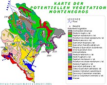
Blečić and Lakušić recorded 454 vegetation units in Montenegro (37 classes, 53 orders, 97 associations and 267 associations). The map of potential vegetation of Montenegro shows 20 basic types of vegetation - 18 forest types and 2 grass communities. Large parts can, however, only be regarded as degraded and are substitute societies made up of derivatives of potential vegetation and anthropogenically favored forms.
The most striking feature is the immediate spatial proximity of alpine high mountains and Mediterranean lowlands. Due to the meridional gorges, a sub-Mediterranean floral character is possible down to the valley areas of the main chains of the high Dinarides. Canyons were beyond glacial Refugialräume and biogeographically-flore historically enlightening.
The Illyrian flora province as a sub-region of the Eurosiberian region is characterized by typical nemoral and boreal tree representatives ( beech , spruce , silver fir ). Central European horological elements are largely decisive in forest vegetation. They extend directly to the coast in the mountains around the Bay of Kotor . The narrow Mediterranean coastline inside the bay is a few hundred meters wide; the hard foliage vegetation extends up to 600 m, sub-Mediterranean formations up to 1000 m, beeches dominate above 1000 m and armored pines can be found from 1500 m.
The sea-facing slope of the Dinaric coastline belongs to the (sub) Mediterranean region of the Adriatic Province, while the sea-remote side belongs to the Illyrian sub-region of the Central European flora region. There are 3136 species of vascular plants (Pteridophyta, Pinophyta, Magnoliophyta) recorded in Montenegro, including 201 endemic species. Glacial relics are common in Durmitor and Prokletije , and tertiary relics in Orjen .
The southern European mountain flora is represented by the Dinaric province. The southeast Dinarides have a rich temperate, (sub) Mediterranean and oromediterranean flora with significant occurrence of Illyrian endemics. Local endings can be found particularly in Orjen (8) and Prokletije (15). The Prokletije offers the greatest biodiversity with 542 species, while the Orjen has 243 species of orophytes.
Topography and relief play an important role in the formation of the floral regions in the border location. The mountain barrier of the littoral Dinarides (800–1900 meters) fends off the Mediterranean climatic influence on the steep step to the Adriatic Sea, further reaching out is only possible via the depressions. The subtropical biome and with it the Adriatic flora province therefore only occupies the narrow area of the Dalmatian coast. The bay of Kotor , which extends into the high karst zone , leads Mediterranean floral elements to the snow-covered Orjen. Thermophilic species such as the paleo-endemic semi-evergreen Macedonian oak ( Quercus trojana ), European hop beech ( Ostrya carpinifolia ), oriental hornbeam ( Carpinus orientalis ) and manna ash ( Fraxinus ornus ) are found in the sub-Mediterranean zone.
literature
- Thede Kahl: Basics of the spatial structure of Serbia and Montenegro . In: Österreichische Osthefte 47 / 1–4, special volume Serbia and Montenegro, Vienna a. a. 2006, pp. 5-30.


