Zla Kolata
| Zla Kolata / Kollata e Keqe | ||
|---|---|---|
|
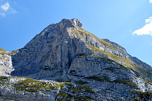
North face |
||
| height | 2534 m | |
| location | Montenegro / Albania | |
| Mountains | Prokletije | |
| Dominance | 0.75 km → Kollata | |
| Notch height | 100 m | |
| Coordinates | 42 ° 29 '6 " N , 19 ° 53' 46" E | |
|
|
||
| rock | Karstified limestone | |
| Normal way | Mountain hike from Gusinje | |
| particularities | Highest mountain in Montenegro | |
|
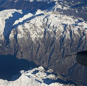
Aerial view in winter - Zla Kolata top left |
||
The Zla Kolata ( Cyrillic Зла Колата ; Albanian Kollata e keqe ) is a 2534 m. i. J. high peak in Prokletije on the Albanian - Montenegrin border. It is the highest point in Montenegro. The Zla Kolata is a secondary peak in the Kollata mountain range, the highest peak of which is Maja e Kollatës ( 2552 m above sea level ; Montenegrin: Ravna Kolata ) about one kilometer southeast of all of Albania.
The Kollata is not quite ten kilometers northeast of the Jezerca and not quite twenty kilometers west of the Gjeravica , the two highest mountains of the Prokletijes. It is part of a mountain ridge on the north side of the Valbona valley , which forms the border between the countries and the catchment areas of the Drin and Danube . On the Albanian side, the town of Valbona is at the foot of the mountain. On the Montenegrin side, Gusinje bei Plav is the next place. This is also the most important starting point for ascents.
The name of the mountain means Bad Kolata . Another secondary peak is the Gute Kolata ( Dobra Kolata or Kollata e mirë ), with 2528 m. i. J. the second highest point in Montenegro, which is a little more than 100 meters northeast and through a 2416 m. i. J. high saddle is separated. The meaning of Kolata is unclear; the name Kolac , which also appears, means heap .
The Kollata is a heavily karstified area. From the highest point, a rather flat ridge, which slopes steeply, especially on the north side, leads down to the northwest to a saddle from where the peaks of Zla Kolata and Dobra Kolata rise steeply. To the north, the summit of Zla Kolata drops into rock faces. The ridges from the summit to the northwest and northeast form the watershed and the border between the countries. The ridge running to the south-south-west later drops steeply into the Valbona valley. The summit region is always covered by snow until early summer.
Very often the mountain Bobotov Kuk ( 2522 m. I. J. ) is given in the Durmitor as the highest mountain in Montenegro. On the one hand, this is due to the fact that it is completely within the territory of the country. Other explanations point to the important role played by the durmitor in Montenegrin culture.
In addition, different heights are given for the Zla Kolata, the exact value does not seem to be clear. For the Zla Kolata a height of 2534 m is usually used . i. J. stated how it would tower over the Bobotov Kuk by eleven meters. This height is also painted on a stone on the summit. Albanian maps, on the other hand, show an altitude of only 2519 m above sea level. A. In older Yugoslav literature it is said from an altitude of 2530 m. i. J. spoke without specifying which Montenegrin summit is meant by Maja Kolac . A new map of the Montenegrin Prokletije even shows an altitude of 2535 m. i. J. stated. In an ascent report, however, it is claimed that the height of the Zla Kolata was never measured correctly and that our own GPS measurements showed an altitude of 2528 m . This is also occasionally listed in books. With one exception, however, all the figures are higher than the official value of the Statistical Office of Montenegro for the Bobotov Kuk .
In August 2012, two Czechs died while climbing the Zla Kolata.
literature
- Max Bosse, Kathrin Steinweg: Peaks of the Balkans (= Rother hiking guide ). Bergverlag Rother, Munich 2016, ISBN 978-3-7633-4491-8 , p. 118-124 .
Web links
- SummitPost: Kolac (Kolata)
- Hikr.org: Zla Kolata / Kolata e Keq 2534 m
- Pictures of an ascent in May 2013
Individual evidence
- ↑ a b Virtual Mountain Tour - Zla Kolata. In: VirtualMountains.co.uk. 2012, accessed March 17, 2013 .
- ^ Dobre Kolata, Montenegro. In: Peakbagger.com. Retrieved March 15, 2013 .
- ^ Miroslav Marić: Zla Kolata (Kollata e Keqe), The peak of Montenegro. In: TakeAdventure. Archived from the original on March 20, 2016 ; accessed on March 16, 2013 .
- ↑ Montenegro Statistical Office (Ed.): Montenegro in Figures 2012 . Podgorica 2012 ( publication as PDF [accessed March 20, 2013]).
- ↑ European Summit Challenge: Montenegro - Bobotov Kuk, Durmitor 2522m. In: VirtualMountains.co.uk. June 2007, accessed on March 17, 2013 (English): “At present it is unclear why neither of these peaks are officially recognized as the highest. There are few possibilities ranging from the love for, and iconic status of the Durmitor range in the Montenegrin culture, the fact that Bobotov Kuk stands wholly in Montenegrin territory whilst those in the Prokletije are shared with Albania. "
- ↑ a b c Miroslav Marić: Zla Kolata (Kollata e Keqe), The peak of Montenegro. In: TakeAdventure. September 6, 2012, accessed on March 16, 2013 (English): "[…] some unconfirmed sources specify the elevation of 2534m. […] As far as I know none officially confirmed this value. According to VGI Beograd source the elevation of Zla Kolata (Kollate e Keqe) peak is 2528m. [...] I measured with 2 different GPS units (Oregon 550 & eTrex 30) and used waypoint averaging technique (minimum 5 minutes under the open sky, with and without EGNOS mode). In all cases my GPS units measured the values between 2527 & 2529m. For Dobra Kolata (albanian: Kolata e Mirë) I measured the values between 2525 & 2527m. "
- ↑ Maja Kolata. In: Peakbagger.com. Retrieved March 21, 2013 .
- ↑ Official map 1: 50,000 of the military cartographic office of Albania, sheet K-34-52-D, 2nd edition, Tirana 1988
- ↑ Jugoslavenski Leksikografski Zavod (ed.): Enciklopedija Jugoslavije . tape 2 . Zagreb 1980.
- ↑ Savezni zavod za statistiku (Ed.): Statistical Pocket-book of Yugoslavia . Belgrade 1978.
- ↑ Montenegro. Prokletije. Planinarenje i biciklizam. Karta 1: 50,000 . Kartografija Huber, Belgrade 2009, ISBN 978-3-940686-15-2 .
- ^ Rudolf Abraham: The Mountains of Montenegro. A Walker's and Trekker's Guide . Cicerone Press, Milnthorpe 2007, ISBN 978-1-85284-506-3 .
- ↑ Černé Hoře zahynuli dva Češi, otec a syn se zřítili ze 400 meters. In: iDnes.cz. August 27, 2012, Retrieved March 16, 2012 (Czech).


