Collata
| Collata | ||
|---|---|---|
|
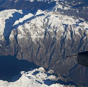
Aerial view in winter from the south - the secondary peaks to the left behind the main peak |
||
| height | 2554 m | |
| location | Montenegro / Albania | |
| Mountains | Prokletije | |
| Dominance | 8.3 km → Maja Grykat e Hapëta | |
| Notch height | 518 m ↓ Qafa e Prosllopit | |
| Coordinates | 42 ° 29 '3 " N , 19 ° 54' 28" E | |
|
|
||
| rock | Karstified limestone | |
| Normal way | Mountain hike from Valbona | |
|
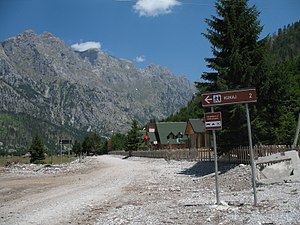
South face of the Kollata seen from Valbona |
||
The Kollata ( Albanian also Mal i Kollatës ; Serbo-Croatian Колата / Kolata ) is 2554 m above sea level. A. high mountain massive in Prokletije in Albanian - Montenegrin border. The main peak Maja e Kollatës ( Serbian - Cyrillic Ravna Kolata ) is located around 800 meters southeast of the border and is one of the ten highest peaks of the Prokletijes.
The Kollata is not quite ten kilometers northeast of the Jezerca and not quite twenty kilometers west of the Gjeravica , the two highest mountains of the Prokletijes. It is part of a mountain ridge on the north side of the Valbona valley , which forms the border between the countries and the watershed between the catchment areas of the Drin and Danube . In a broader sense, the whole mountain range north of the Valbona including Maja Rosit ( Serbo-Croatian Rosni Vrh / Росни Врх ; Albanian also Maja e Roshit ; 2524 m above sea level ) in the west is called the mountain range of the Kollata ( Albanian Blloku i Kollatës ). In Montenegro the massif is known as the Belić group . The Jezerca massif connects to the west of the Maja Rosit , and in the east it drops into the Çerem valley, a left tributary of the Valbona.
On the Albanian side, the village of Valbona is at the foot of the mountain. On the Montenegrin side, Gusinje bei Plav is the next place. The landscape is protected on both sides of the border, in Albania as the Valbonatal National Park , in Montenegro as the Prokletije National Park .
The Kollata is characterized by steep slopes - up to 1500 meters to the south - and comparatively flat mountain ridges and karst fields in the summit area. To the west, north and east of the summit are three cirques with deeply sloping rock walls. The largest cirque west of the summit, which opens to the northeast, is followed by a fairly flat ridge to the south, which extends to the main summit. In the northwest of the Kars, two steeply rising secondary peaks tower over the terrain by around 100 meters. The western one is called Zla Kolata ( Cyrillic Зла Колата , Albanian Kollata e keqe , Bad Kollata ) and is 2534 m. i. J. the highest point in Montenegro. The Dobra Kolata ( Cyrillic Добра Колата , Albanian Kollata e mirë , Good Kollata ) is 2528 m. i. J. the second highest point in Montenegro. Another cirque opens to the north between Dobra and Zla Kollata. There are numerous different elevations for the peaks of the Kollata.
In the large, round Karbefindet situated at an altitude of around 2200- 2300 m above sea level. A. a small Kar glacier around 300 meters long and 200 meters wide. This small glacier is one of the southernmost in Europe. Several other snowfields around the Kollata are probably not glaciers.
literature
- Akademia e Shkencave e RPSSH (ed.): Gjeografia fizike e Shqipërisë . tape II . Tirana 1990, p. 68-85 .
- Max Bosse, Kathrin Steinweg: Peaks of the Balkans (= Rother hiking guide ). Bergverlag Rother, Munich 2016, ISBN 978-3-7633-4491-8 , p. 118-124 .
Web links
Individual evidence
- ↑ Official map 1: 50,000 of the military cartographic office of Albania, sheet K-34-52-D, 2nd edition, Tirana 1988
- ↑ Bernhard Bauer, Ludwig Obersteiner, Rolf Richer: To the development of the North Albanian Alps . Yearbook. In: Journal of the German and Austrian Alpine Association . tape 67 . Publishing house of the German and Austrian Alpine Club, Stuttgart 1936, p. 216-229 .
- ^ Miroslav Marić: Zla Kolata (Kollata e Keqe), The peak of Montenegro. In: TakeAdventure. September 6, 2012, accessed on March 16, 2013 (English): "[…] some unconfirmed sources specify the elevation of 2534m. […] As far as I know none officially confirmed this value. According to VGI Beograd source the elevation of Zla Kolata (Kollate e Keqe) peak is 2528m. [...] I measured with 2 different GPS units (Oregon 550 & eTrex 30) and used waypoint averaging technique (minimum 5 minutes under the open sky, with and without EGNOS mode). In all cases my GPS units measured the values between 2527 & 2529m. For Dobra Kolata (albanian: Kolata e Mirë) I measured the values between 2525 & 2527m. "
- ↑ Emil Gachev: The Unknown Southernmost Glaciers of Europe . In: Danilo Godone (Ed.): Glacier Evolution in a Changing World (= Earth and Planetary Sciences ). InTechOpen, Rijeka 2017, ISBN 978-953-513-543-2 , p. 90-93 , doi : 10.5772 / intechopen.68899 .


