Maja Rosit
| Maja e Rosit / Rosni Vrh / Росни Врх | ||
|---|---|---|
|
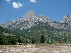
Maja Rosit in the right foreground seen from the east ( Zla Kolata ) |
||
| height | 2524 m | |
| location | Montenegro / Albania | |
| Mountains | Prokletije | |
| Dominance | 0.75 km → Kollata | |
| Notch height | 100 m | |
| Coordinates | 42 ° 28 '46 " N , 19 ° 51' 2" E | |
|
|
||
| rock | Karstified limestone | |
| Normal way | Mountain hike from Gusinje or Valbona over the west ridge | |
|
Maja Rosit on the far left behind Maja e Thatë |
||
The Maja Rosit ( Serbo-Croatian Rosni Vrh / Росни Врх ; Albanian also Maja e Roshit , translated as Ros summit ; rarely Maja Rozit ) is a 2524 m. i. J. high peak in Prokletije on the Albanian - Montenegrin border. It is the second highest elevation in Montenegro after the Zla Kolata ( 2534 m. I. Y. Y. ) And before the Bobotov Kuk ( 2522 m. Y. Y. ) In the Durmitor .
The Jezerca , at 2694 m above sea level. A. highest mountain of the Prokletije, lies a little more than five kilometers southwest. The mountain rises between the Jezerca massif and the Kollata ( 2552 m above sea level ). In the south the terrain drops steeply from the Valbona valley. The Maja Rosit cannot be seen from the village of Valbona , however, because it is covered by the Maja e Thatë ( 2405 m above sea level ) on the pointed southeast ridge. In the north, after the initial rock faces, it is somewhat flatter in the summit area than on the south side, so that Herbert Louis speaks of a broad " plateau-like mountain mass ", which here in the north of the Valbona valley forms the watershed between Drin and Lim or Danube .
Like the whole region, the Maja Rosit is made of limestone .
The ascent over the saddle in the west is long and steep, but without any problems due to the lack of climbing spots. The summit area consists of steep meadow slopes. On the Montenegrin side, the mountain is climbed from Vusanje near Gusinje via the Ropojana valley and the Roman pasture . From the summit there is a wide panorama of the Prokletije mountains.
Notes on the height
-
↑ The altitude indication of 2524 meters can be found most frequently on most maps and also in other sources. There are, however, numerous deviating values:
On Albanian maps the height is 2522.2 m above sea level. A. stated, cf. Map 1: 50,000 of the Military Cartographic Office of Albania, sheet K-34-52-D. A sign on the summit shows the height at 2522.5 m ( video on YouTube ). The statistical office of Montenegro Monstat gives the height of the mountain with 2522 m. i. J. an (Montenegro Statistical Office (Ed.): 2016 Statistical Yearbook . Podgorica 2016, p. 19.).
In other books there are values like 2525 m. i. J. (Abraham 2007), 2525 m above sea level A. (Piero Ghiglione: Malet e Shqipnisë . Distaptur, Tirana 1942) or even 2526 m above sea level. A. (Akademia e Shkencave e RPSSH (ed.): Gjeografia fizike e Shqipërisë. Tirana 1990, Volume II, p. 72).
Web links
- Journey to Valbona: Maja e Rosit (English) ( Memento from January 1, 2018 in the Internet Archive )
- SummitPost: Rosni Vrh
- Tour report on hikr.org
Individual evidence
- ↑ Official map 1: 50,000 of the military cartographic office of Albania, sheet K-34-52-D, 2nd edition, Tirana 1988
- ↑ Lexicographical Institute Miroslav Krleža (ed.): Hrvatska enciklopedija . 2nd Edition. tape 2 . Zagreb 1999, ISBN 953-6036-32-0 , Crna Gora, p. 610 .
- ^ Planinarsko Drustvo "Karanfil" Gusinje. In: Gusinje-Plav.com. Retrieved February 11, 2017 (Serbian).
- ^ A b Rudolf Abraham: The Mountains of Montenegro. A Walker's and Trekker's Guide . Cicerone Press, Milnthorpe 2007, ISBN 978-1-85284-506-3 , pp. 197 .
- ↑ a b Herbert Louis: Albania. A knowledge of the country mainly because of my own travels . Published by J. Engelhorn's successors in Stuttgart, Berlin 1927, p. 153 .
- ↑ What to do. In: Journey to Valbona. Archived from the original on February 12, 2017 ; accessed on February 11, 2017 (English).


