
Prokletije National Park
| Prokletije National Park | |||
|---|---|---|---|
 |
|||
|
|||
| Location: | Montenegro | ||
| Specialty: | High mountains, glacial lakes | ||
| Next city: | Plav | ||
| Surface: | 166.30 km² | ||
| Founding: | 2009 | ||

The Prokletije National Park ( Serbian - Cyrillic Национални парк Проклетије ) is one of five national parks in Montenegro . The 16,630 hectare area covers most of the Montenegrin Prokletije Mountains. It was founded in 2009.
The national park is located south of the town of Plav in the southeast of the country. It extends south of the Lim river along the border with Albania , with practically only the valley floors being populated. The Karst Mountains are very rugged. Many of the highest mountains in Montenegro can be found here, such as the Karanfili ( 2490 m. I. Year ) in the western part of the national park, on the border with Albania to the east of it the Maja Rosit ( 2524 m. I. Year ) and the Zla Kolata , which at 2538 m . i. J. Montenegro's highest point, as well as the part called Bogićevica in the east with the Veliki krš ( 2374 m. I. J. ) as the highest point. In addition to larger streams that formed deep valleys and gorges, there are also some mountain lakes.
The untouched mountain world with a lot of forest has a rich fauna and flora and various endemic species . The area extends over several levels of vegetation.
The national park offers its visitors a wide range of opportunities for hiking and mountain tours, climbing, winter sports, bicycle trips and water sports.
photos

Mountains in the Grbaja Valley (view of Albania)

Ropojana valley south of Gusinje

waterfall
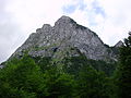
Rugged karst mountains
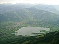
View from the visitor over the Plav lake into the national park

Karst spring Oko Skakavice


.jpg)

Web links
Individual evidence
- ↑ a b c Nacionalna Park Prokletije. In: Nacionalni parkovi Crne Gore. Retrieved April 25, 2013 (Serbian).
- ↑ Feasibility Stdy, NP Prokletije (2006). ( MS Word ; 875 kB) Republički Zavodu za zaštitu prirode Crne Gore, accessed on April 25, 2013 (Serbian).
- ↑ Crna Gora bogatija za novi Nacionalni Park - Prokletije. In: Pobeda. December 6, 2009, Retrieved April 25, 2013 (Serbian).