
Krafla
| Krafla | ||
|---|---|---|
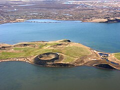
 Aerial photo of Krafla and Víti crater with several boreholes |
||
| height | 818 m | |
| location | Iceland | |
| Coordinates | 65 ° 43 '59 " N , 16 ° 46' 59" W | |
|
||
| Type | Caldera | |
| Last eruption | 1984 (active) | |
| Normal way | from the east side | |
 Kraflafeuer 1983 |
||
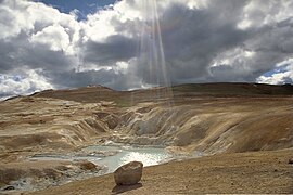
 View from Námaskarð to the Krafla in the background |
||


The Krafla [ ˈkʰrapla ] is a volcanic system of around 100 km in length in the north of Iceland . The central volcano of the same name, 818 m high, dominates the Mývatn region with numerous craters .
More detailed description
The Krafla volcanic system consists of a central volcano with a caldera and an elongated fissure swarm. The latter is about 10 km wide and extends for about 100 km in a north-south direction. At the southern end is z. B. the selfjall tabular volcano . In the north the system extends into the fjord Öxarfjörður .
The central volcano Krafla itself, under which a magma chamber lies at a depth of about 3 km, consists primarily of a large caldera (10 km in cross section). It is over 200,000 years old. The volcano was built up through eruptions under ice as well as in the air, i.e. H. Activities could also be demonstrated during the ice age.
Eruption story
Based on: Thor Thordarson, Armann Hoskuldsson: Iceland - Classic Geology in Europe 3. Harpenden 2002, pp. 145 ff.
Prehistoric outbreaks
The caldera itself was formed from enormous explosive eruptions that collapsed magma chambers more than 100,000 years ago.
On the outer edge of the caldera are u. a. two rhyolitic tabular volcanoes, Hlíðarfjall and Jörundur , which formed under glaciers during the Ice Age.
Eruptions after the Ice Age
The more recent eruptions began with the formation of the Lúdent tuff ring more than 6,600 years ago. Soon thereafter, further series of eruptions followed in nearby crevices and also on Námafjall .
The older Laxá lavas
The extensive so-called Elder Laxá lavas streamed into the area of the Krafla volcano about 3800 years ago, but were formed during the eruptions of the Ketildyngja shield volcano, which belongs to the neighboring Fremrinámur system . The outflow of the river Laxá í Aðaldal was blocked so that Lake Mývatn began to form behind it (see also the formation of Lake Þingvallavatn ). The lavas then followed the Laxá valley for 50 km until they finally flowed into the Skjálfandi bay .
Hverfjall
The Hverfjall tuff ring owes its existence to a hydromagmatic explosion , i. H. the meeting of magma with groundwater, in connection with a new series of eruptions about 2800 years ago.
On June 22, 2011, Hverfjall was placed under nature protection together with Dimmuborgir.
The younger Laxá lavas
Not far from Hverfjall there were further series of eruptions in the Lúdentsborgir crater series about 2000 years ago. These produced the so-called younger Laxá lavas .
This series of eruptions is at the origin of today's picturesque appearance of the area around the Mývatn. Because here z. B. a lava lake , the residues of which today form the lava labyrinth of Dimmuborgir , as well as the numerous pseudocraters , both as islands in the lake and on land, for example at Skútustaðir .
Mývatn Fire and Víti Crater
In the 18th century there were again larger series of eruptions after Krafla had rested for about 1000 years. This was later called the Mývatn fire (Isl. Mývatns-Eldar ).
These were phases of unrest and eruption that stretched over 5 years, from 1724 to 1729.
On May 17, 1724, the unrest episode began with another hydromagmatic explosion that formed Víti crater . Víti means hell in Icelandic . There is a second crater of this name southeast of Mývatn on the Askja . Today there is a maar in Víti , which gets its turquoise color from the silica algae.
Repeated eruption phases dragged on until 1729. The eruptions also included the area of Leirhnjúkur and even the immediate area of Reykjahlíð where you at Bjarnaflag lava fountains could see.
The three courtyards that existed here at the time had to be cleared. However, the church, which stands on a small hill, was preserved.
Further eruptions followed in 1746.
During this unrest phase there were also strong earthquake and rifting phases .
Krafla fire
The so far last series of eruptions of the Krafla took place from 1975 to 1984, the so-called Krafla-Feuer (Isl. Kröflueldar ).
The naming suggests that most of the eruptions now took place in the Krafla Caldera itself and there especially on and near the Leirhnjúkur volcano . The lava fields there are still warm and degassed, as is the summit and the high temperature area with its solfataras , mud springs and fumaroles at its base.
Earthquakes up to magnitude 4 could be measured. The soil throughout the system deformed, rifting, inflation and deflation of the caldera floor. Overall, the fissure swarm widened by 900 mm during the 9-year unrest phases.
In this way, scientists were able to prove that rifting and spreading are not a continuous process, but rather take place in bursts (see plate tectonics ).
Hverarond high temperature area
Solfataras and mud springs characterize the nearby high-temperature area of Námaskarð or Hverarönd on the east side of the Námafjall volcano, which is part of the Krafla system . It also belongs to this volcanic system.
Use of geothermal energy
Geothermal power plants
Geothermal energy has been used since 1977 by means of two geothermal power plants, Bjarnaflagsstöð near Reykjahlíð and Kröfluvirkjun directly on the central volcano Krafla.
Deep drilling in a central volcano
When drilling deep into the Krafla Caldera, a team of researchers unexpectedly came across rhyolite magma at a depth of 2,100 m.
One considers whether one could use water layers closer to the magma for energy production.
On the other hand, conservationists such. The journalist Ómar Ragnarsson, for example, opposed the deep boreholes because they believed that the technical systems were affecting the beauty of the landscape and that they were also causing considerable noise.
Hiking on the Krafla
The area in the area of the central volcano is one of the most interesting hiking areas in Iceland. It is also one of the best served by hiking trails.
You can choose from a wide variety of simple and medium difficulty levels.
Easy hikes lead, for example, on mostly wide paths through the remains of the lava lake at Dimmuborgir or around and on the pseudocrater of Skútustaðir as well as through the high temperature area Hverarönd or on the Víti crater . Tours on Vindbelgjarfjall and around and on Leirhnjúkur and from there down to the lake to Reykjahlíð in about five hours are of medium difficulty .
Photo gallery

Hverfjall

Dimmuborgir
Pseudocrater at Skútustaðir

Central volcano Krafla, seen from the high temperature area Hverarönd, which is part of the Krafla system
Leirhnjúkur
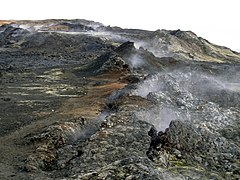
Still hot lava fields, on Leirhnjúkur, 2007

Borehole
Lava field at Leirhnjúkur
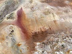
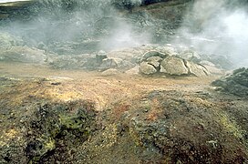
Sulfur field at Víti

Aerial view of the Jörundur rhyolitic tabular volcano

Small lake in Krafla


See also
- Geography of Iceland
- Volcanoes in Iceland
- Geothermal energy in Iceland
- List of mountains and elevations in Iceland
Web links
Photos and videos
Geological background
- Krafla in the Global Volcanism Program of the Smithsonian Institution (English)
- Geol. Inst., Univ. Iceland: Geological description of the Krafla (English)
- E. Sturkell, ea: Multiple volcano deformation sources in a post-rifting period: 1989-2005 behavior of Krafla, Iceland constrained by leveling, tilt and GPS observations , Journal of Volcanology and Geothermal Research, Vol. 177, iss. 2 (2008), 405-417; doi : 10.1016 / j.jvolgeores.2008.06.013 (developments of the volcano since the last eruptions in 1986)
- H. Tuffen & Castro, The emplacement of an obsidian dyke through thin ice: Hrafntinnuhryggur, Krafla Iceland , Journal of Volcanology and Geothermal Research, Vol. 185, iss. 4 (2009) (interaction of ice age glaciers and volcanism on the Krafla) doi : 10.1016 / j.jvolgeores.2008.10.021
- AJL Harrisa, ea: Effusion rate trends at Etna and Krafla and their implications for eruptive mechanisms , Journal of Volcanology and Geothermal Research 102 (2000) 237–270 (PDF file, English; 901 kB)
- Hugh Nicholson, D. Latin ;: Olivine Tholeiites from Krafla, Iceland: Evidence for Variations in Melt Fraction within a Plume , Journal of Petrology, Vol. 33, iss. 5 (1991), 1105-1124 (abstract, English)
- Rifqa Agung Wicaksono: Crustal conductivity and distribution of melt beneath the Krafla caldera, N-Iceland inferred from magnetotelluric data , Faculty of Earth Sciences, Univ. of Iceland, 2010 (PDF file, English)
- Hélène Le Mével: Relationship between seismic and gravity caused anomalies at Krafla volcano, Iceland. BS research project, Univ. of Nantes, France, 2009, superv. Magnús T. Gudmundsson, Univ. of Iceland (PDF file, English; 2.3 MB)
To the nature reserve on the Krafla
- National Park Service: Information about Myvatn area with description of hiking trails (English)
- Umhverfisstofnun: Mývatn (German-language information on the nature reserve) (PDF; 270 kB)
- Description of Dimmuborgir and the hiking trails there (PDF, English; 316 kB)
Individual evidence
- ↑ a b Thor Thordarson, Ármann Höskuldsson: Iceland. Classic Geology in Europe 3. Harpenden, 2002, p. 144 ff.
- ↑ cf. z. B. Fremrinamur in the Global Volcanism Program of the Smithsonian Institution (English)
- ↑ http://wayback.vefsafn.is/wayback/20110729230845/www.ruv.is/frett/fridlysing-dimmuborga-og-hverfjalls Friðlýsing Dimmuborga og Hverfjalls . Website of the daily Morgunblaðið of June 22, 2011 (Icelandic); Accessed June 29, 2011
- ↑ Thor Thordarson, Armann Hoskuldsson: Iceland. Classic Geology of Europe 3. Harpenden 2002, p. 147
- ^ Hans Ulrich Schmid, Dictionary Icelandic-German. Hamburg 2001, p. 288
- ↑ see also: [1] accessed: March 18, 2010, Geol. Inst., Univ. Iceland to the Kraflafeuern, engl.
- ↑ cf. z. B. [2] accessed: March 18, 2010, Geol. Institut d. Univ. Iceland to the Mývatn Fires, engl.
- ↑ http://www.nsf.gov/news/news_summ.jsp?cntn_id=118683&org=GEO&from=news Iceland Volcano's Molten Rock Could Become Source of High-Grade Energy. Krafla volcano gives geologists unique, unexpected opportunity to study magma. National Science Foundation, Press release, 11-033 (English); Accessed July 27, 2011
- ↑ cf. also http://www.mbl.is/frettir/innlent/2009/06/10/enn_eru_erfidleikar_vid_djupborun/ Enn eru erfiðleikar við djúpborun , Mbl.is, June 10, 2009 (Icelandic); Accessed July 27, 2011
- ↑ cf. http://omarragnarsson.blog.is/blog/omarragnarsson/entry/893944/ Blog of the journalist Ómar Ragnarsson of June 10, 2009 (Icelandic, with photos of the deep drilling rigs); Accessed July 27, 2011
- ↑ cf. about http://wayback.vefsafn.is/wayback/20060304022924/english.ust.is/National-Parks/Protectedareas/MyvatnandLaxa accessed October 2, 2010; see. also Ari Trausti Guðmundsson, Pétur Þorsteinsson: Íslensk fjöll. Gönguleiðir á 151 tind. Reykjavík 2004, v. a. P. 298 (Vindbelgjarfjall) and p. 178 (Krafla)