
Þingvallavatn
| Þingvallavatn | ||
|---|---|---|

|
||
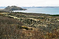
| Aerial view with a lake in the middle distance | ||
| Geographical location | Iceland | |
| Tributaries | Öxará | |
| Drain | So-called | |
| Islands | Sandey, Nesjaey | |
| Data | ||
| Coordinates | 64 ° 11 ′ N , 21 ° 8 ′ W | |
|
||
| surface | 83.7 km² | |
| Maximum depth | 114 m | |

|
||
| The lake seen from the west | ||

The Þingvallavatn [ 'θiŋkˌvatlaˌvahtn̥ ] is a lake in southwest Iceland in the Þingvellir National Park . It is located in the municipality of Grímsnes og Grafningur and Bláskógabyggð .
General
It is disputed whether it is the largest lake on the island with its 83.7 km². The position of the Þórisvatn reservoir has been contested with him for several years. The question is also whether the volcanic islands lying in it with a surface of at least 0.5 km² are to be added to its surface or not. In addition, the lake has been used by a power station at its outflow since 1959 and is therefore slightly dammed so that the surface can fluctuate. Its greatest depth is 114 m.
The Þingvallavatn is very rich in fish. Represented fish species are, in addition to sticklebacks , four different types of char , including the arctic char ( Salvelinus alpinus ) and trout species. The lake trout ( Salmo trutta ) is the top of the lake's food chain, weighing up to 15 kg.
Volcanism and crevice formation
The lake is located in the so-called Þingvellir Graben and is surrounded by four active volcanic systems: Prestahnúkur and Hrafnabjörg in the northeast and Hengill and Hrómundartindur in the southwest.
The assumed age of the lake is around 12,000 years. It was created at the end of the last ice age . It was initially a glacial lake . The glacier denied at the end of the last ice age the outflow of water. Eventually the glaciers retreated, the land below the Hengill volcano rose and the lake deepened.
A decisive change came about 10,000 years ago when the neighboring shield volcano Skjaldbreiður, which is part of the Hrafnabjörg volcanic system, was formed in a single long eruption. The lava not only built up the shield volcano itself, but continued to pour through the valleys towards the lake. Another large volcanic eruption shaped the area around 1,000 years later: This time it was the Hrafnabjörg volcano itself, which is even closer to the lake, which poured its lava into the lake and impeded its drainage when the river was sucked . As a result, the lake water rose by approx. 12 m. The river, however, dug its bed through the lava and the water surface sank again by approx. 7 m.
The Hengill volcano erupted about 2,000 years ago and an island was created in the middle of the lake that is now called Sandey . Nowadays the lake gets its water mainly from numerous above and below ground sources in the neighboring lava fields .
It is also located in the middle of the rift zone of the mid-Atlantic ridge , which stretches diagonally from southwest to northeast over Iceland. As a result, there are many smaller and larger crevices in the area, which in Iceland are called gjá . The largest is the Almannagjá in Þingvellir , the most impressive but the Hrafnagjá . There are also such crevices under the lake, one of them significantly at its deepest point.
Historic site
From the time of the conquest of the land , d. H. the settlement of Iceland, the area around the lake. At its northern bank met after only 930 by the year 1800 at Thingvellir the Legislative Assembly Alþing , one of the oldest parliaments in Europe.
See also
literature
- Pétur M. Jónasson et al. a. (Ed.): Thingvallavatn. A unique world evolving , Opna, Reykjavík 2011, ISBN 978-9935-10-009-2 .
Web links
- Official website (English)
- Geology of the area of Thingvellir (English)
- The old parliament building in Þingvellir
Picture gallery

The lake from the Hengill

Þingvallavatn from the north bank
Hrafnagjá on Þingvallavatn

View from Hengill to the lake
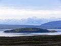
Sandey Island

Þingvallavatn with the volcanic island of Sandey


_(Kenny_McFly).jpg)