Þórisvatn
| Þórisvatn | |||
|---|---|---|---|
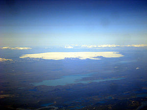
| The lake in front of the Hofsjökull glacier shield | |||
|
|||
|
|
|||
| Coordinates | 64 ° 14 '0 " N , 18 ° 55' 0" W | ||
| Data on the structure | |||
| Construction time: | 1999-2001 | ||
| Power plant output: | 90 MW | ||
| Operator: | Landsvirkjun | ||
| Data on the reservoir | |||
| Altitude (at congestion destination ) | 577 m | ||
| Water surface | 88 km² | ||
The Þórisvatn is a lake in the Icelandic highlands . Most of it is in the municipality of Ásahreppur and a small part in the municipality of Rangárþing ytra .
Geography and description
Þórisvatn, the largest lake in Iceland , is located at the southern end of the Sprengisandur slope and north of the volcanic Veiðivötn .
It is a lake, which has been considerably enlarged by damming, with a surface area between 83 and 88 km² and a water depth of up to 113 m.
The water from numerous springs is collected here. The Kaldakvísl River has been diverted and flows into the reservoir. The water energy is used in the Vatnsfell power plant , from where the water flows into the Sigöldulón .
What is striking is the mostly turquoise-green color of the lake, which stands out so clearly from the gray-black lava desert all around.
See also
Web links
Individual evidence
- ↑ lmi.is: Iceland in statistics ( Memento from May 2, 2007 in the Internet Archive )

