
Hengill
| Hengill | ||
|---|---|---|
 Hengill across the lake Þingvallavatn |
||
| height | 803 m | |
| location | Iceland | |
| Coordinates | 64 ° 5 '8 " N , 21 ° 18' 49" W | |
|
||
| Type | Central volcano with its own column system | |
| rock | v. a. Palagonite and pillow lavas | |
| Age of the rock | Saale ice age | |
| Last eruption | at the turn of the century (active) | |
| Normal way | from the west side | |
 Craters and islands of the Hengill system in the foreground and middle distance |
||

Hengill (isl., [ ˈHeiɲcɪtl̥ ]) is a volcanic system in the southwest of Iceland . Basically the area comprises three active central volcanoes . One, located in the municipality of Ölfus and Grímsnes og Grafningur , is also called Hengill , the other is called Hrómundartindur , and a third is in Grensdalur .
Is defined as the area in the Volcanology as Hengill- triple point , because here the Reykjanes Rift zone with the Westisländischen active volcano zone (Engl. Western Volcanic Zone ) coincide and both also on the Southern Icelandic Verwerfungs- and fracture zone (Engl. South Icelandic seismic transform Zone ).
The volcanic system
Sphere of influence
The Hengill volcanic system extends over an area of around 100 km in length and 3 to 16 km in width. Its area of influence extends from Selvogur to below the Langjökull glacier . This would make this the most important volcanic system on the Reykjanes Peninsula , if it is still one of them.
Eruption story
Four fissure eruptions have been documented in Hengill since the Ice Age around 10,000 years ago. They mainly took place on the north side of the volcanic system. During the last eruption around 1,900 years ago, the islands on the east side of the central volcano in Lake Þingvallavatn , about the largest of the islands in the lake, Sandey , were formed . In addition, the origin of the lava fields at Nesjavellir , the so-called Nesjahraun, lies here . The youngest lava appeared on Hellisheiði south of the mountain .
Active volcanic system
The area is still volcanically active, as can be seen from the numerous hot springs and fumaroles in the area. It is a high temperature area . For example, in the Innstidalur between Hengill and Skarðsmýrarfjall there is one of the country's most abundant steam sources.
Between 1994 and 2002, an unusually high number of earthquakes were found in the area of the Hengill Triple Point. In addition, GPS measurements showed a significant bulge between the Hrómundartindar and Grensdalur systems. However, these signs of magma injections could no longer be detected after 2002.
Adjacent volcanic systems
Two other older volcanic systems, which were previously counted as further parts of the Hengill system, border that of the Hengill in the east. Hrómundartindur with its high temperature area under the volcano Tjarnarhnjúkur and at Ölkelduháls is located to the northeast of it on Hellisheiði . The small town of Hveragerði with its hot springs is located about 10 km east of the Hengill in the area of the Grensdalur volcano.
On the Reykjanesskagi peninsula, the Brennisteinsfjöll borders to the southeast of the Hengill volcanic system . Some of the boreholes are only 1–2 km away from each other on Hellisheiði around Reykjafjall (Hengill) or on the other side of the ring road at the table volcano Stóri-Metill (Brennisteinsfjöll).
The Hengill massif
The elongated mountain range of the Hengill, oriented from southwest to northeast, and at the same time the central volcano of the volcanic system of the same name, is located in the southwest of Lake Þingvallavatn . It is one of the highest mountains near Reykjavík, the capital of Iceland . Its highest peak, Skeggi , rises 803 m above the sea.
The Hengill itself is a tabular volcano that was largely formed under a glacier during the Ice Age and consists mainly of palagonite . It is surrounded by palagonite and pillow lava backs . The top layers are olivine basalt . Recent research has shown that the mountain was mainly formed in two glacial periods: the lower part probably originates from the penultimate ice age ( Saale glacial period ), the upper part was formed in subglacial eruptions in the last glacial period ( Weichsel glacial period ).
Liparit can also be found in a secondary peak, the Sleggja .
Another central volcano is located south of the Hrómundartindur.
The area with its mountains and hot springs is a well-known hiking area and is therefore well developed with hiking trails.
Geothermal use
The Hengill volcano is an important source of energy for the south of the country.
This is particularly used in the Nesjavellir power station, which, together with the Svartsengi power station on the Reykjanes peninsula, supplies Reykjavík with energy. The Nesjavellir power station is located on the west bank of Lake Þingvallavatn.
In addition, another even larger power plant was built on Hellisheiði , Hellisheiði Power Plant , which also uses the substantial energy source Hengill. It was put into operation in 2008 and has an output of 303 MW and 400 MWth.
Legends and outlaws
In earlier times outlaws are said to have lived in the caves above the Innstidalur .
There are also some legends in the area, such as the folk legend about the troll woman Jóra . It is said to have had the habit of ambushing innocent travelers on their way across the Dyrafjöll to eat them. But she was eventually killed in her sleep by a farmer.
Photo gallery


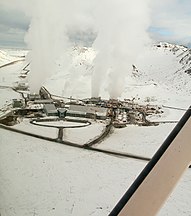
Hellisheiði power station

High temperature area on the Hengill

Nesjavellir power plant

Fumaroles on the Hengill

Hengill seen from the east


See also
Web links
Photos and videos
Scientific contributions
- Hengill in the Global Volcanism Program of the Smithsonian Institution (English)
- M. Krumbholz, Fluid transport along faults and fissures in the area of the Hengill volcano (PDF file)
- Geology of the Thingvellir area
- To the Reykjanes Peninsula, Amy Clifton, Univ. Iceland (English, PDF file; 1.2 MB)
- Overview of the Hengill triple point, Meteorol. Inst., Iceland (English)
- Bulge at the Hengill triple point (PDF file; 4.4 MB) (English)
- KLFeigl, ea: Crustal deformation near Hengill volcano, Iceland, 1993-1998: Coupling between magmatic activity and faulting inferred from elastic modeling satellite radar inferograms. Journal of Geophysical Research, Vol. 105, no.B11, 25,655-25,670, Nov. 2000 (English, PDF file)
Hiking trails and maps
- Hiking trails with maps and photos (text Icelandic)
- Hiking in Marardalur near Skeggi (PDF, Icelandic; 12 kB)
- Hike on the Hengill with GPS data and photos (German)
Individual evidence
- ↑ cf. http://hraun.vedur.is/ja/skyrslur/contgps/node18.html Overview of the Hengill triple point, Meteorol. Inst., Iceland Accessed January 22, 2011
- ↑ Ari Trausti Guðmundsson: Living Earth. Facets of the geology of Iceland. Reykjavík 2007, p. 192
- ↑ Thor Thordarsson, Armann Hoskuldsson: Iceland - Classic Geology third in Europe Harpenden, 2002, p 76
- ↑ http://hraun.vedur.is/ja/skyrslur/contgps/node18.html Accessed: February 12, 2011
- ^ Ari Trausti Guðmundsson, Pétur Þórleifsson: Íslensk fjöll. Gönguleiðir á 151 tind. Reykjavík 2004, p. 102.
- ↑ Íslandshandbókin. 2.bindi. 1989 p. 796.
- ↑ Hence Elmi: Geothermal resource assessment through well and production response modeling. Msc. Thesis. Dep. of Mechanical and Industrial Engineering. Univ. of Iceland. April 2008, p. 30
- ↑ Íslandshandbókin. 2.bindi. 1989 p. 796