Reykjahlíð
| Reykjahlíð | ||
|---|---|---|
|
|
||
| Coordinates | 65 ° 39 ′ N , 16 ° 55 ′ W | |
| Basic data | ||
| Country | Iceland | |
| Norðurland eystra | ||
| ISO 3166-2 | IS-6 | |
| local community | Skútustaðir | |
| Residents | 210 (January 1, 2019) | |
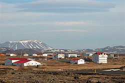
Reykjahlíð [ 'rεiːcaˌl̥iːð ] ( Eng . "Smoke slope") is a place in northeast Iceland. It is the main town in the municipality of Skútustaðir in the Norðurland eystra region . On January 1, 2019, 210 inhabitants lived in the village.
geography
Reykjahlíð is located northeast of the Mývatn (Eng. "Mückensee"). Northeast is the the Krafla belonging -Vulkansystem Hlíðarfjall , slightly further away the Leirhnjúkur .
To the east of Reykjahlíð is the mountain Námafjall , which can be reached via the pass Námaskarð . The caves Stóragjá and Grjótagjá and the Tuffring Hverfell can be found south and south-east of the village . The Fremri-Námur volcano system is located about 25 km south of Reykjahlíð.
climate
Since no month has an average temperature of over 10 ° C, Reykjahlíð can be assigned to the arctic climate zone. Due to its eastern location, which removes the place from the maritime influence of the North Atlantic Current, Reykjahlíð has a comparatively more continental climate than places more south-westerly in Iceland. This favors the occurrence of more extreme temperatures than on the west coast of Iceland, which is also reflected in the record temperatures of 25.6 ° C (July) and −30.9 ° C (March).
| Reykjahlíð | ||||||||||||||||||||||||||||||||||||||||||||||||
|---|---|---|---|---|---|---|---|---|---|---|---|---|---|---|---|---|---|---|---|---|---|---|---|---|---|---|---|---|---|---|---|---|---|---|---|---|---|---|---|---|---|---|---|---|---|---|---|---|
| Climate diagram | ||||||||||||||||||||||||||||||||||||||||||||||||
| ||||||||||||||||||||||||||||||||||||||||||||||||
|
Average monthly temperatures and rainfall for Reykjahlíð
Source: Icelandic Meteorological Office
|
||||||||||||||||||||||||||||||||||||||||||||||||||||||||||||||||||||||||||||||||||||||||||||||||||||||||||||||||||||||||
history
The settlement narrowly escaped a catastrophe in 1729 at the time of the Mývatn fires ( Krafla volcanic eruptions ). Fortunately, the residents were all gathered in the slightly higher church when a large lava flow destroyed their houses, but spared the church hill. Today's church was built on the same site and consecrated in 1962.
Culture and sights

Reykjahlið is the starting point for Krafla with its steaming solfataras and the turquoise blue crater Víti (Eng. "Hell"), to Námaskarð , to Hverfjall and to the pseudocraters of Skútustaðir . About 2000 years ago, the Dimmuborgir (Eng. "Dark castles"), a labyrinth of lava formations, formed.
There are two caves filled with warm water near Reykjahlíð. An underground lava flow has meanwhile heated the water in the Grjótagjá too much for a bath. Closer to the place is the Stóragjá . The water exchange in it is too low for a safe bath.
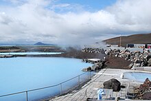
In addition to the outdoor pool in the east of the village, there has also been a natural pool called Jarðböð (earth baths) with turquoise geothermal water similar to the well-known Blue Lagoon on the Reykjanes Peninsula since June 30, 2004 .
traffic
The main thoroughfare of Iceland's Hringvegur runs through the village . The distance to the capital Reykjavík is 488 kilometers and to Egilsstaðir 165 kilometers by road.


