Leirhnjúkur
| Leirhnjúkur | ||
|---|---|---|
|
In the background the summit |
||
| height | 592 m | |
| location | Northeast - Iceland | |
| Mountains | Krafla massif | |
| Coordinates | 65 ° 43 '15 " N , 16 ° 47' 34" W | |
|
|
||
| Type | Crevasse volcano | |
| rock | Palagonite and basalt | |
| Last eruption | 1975 to 1984 | |
| particularities | High temperature area with mud pots at its foot, fumaroles on the flanks | |
|
View from the summit of Leirhnjúkur into the Krafla caldera |
||
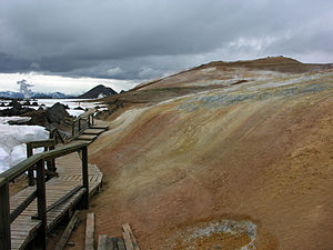
The Leirhnjúkur [ 'lεiːr̥ˌn̥juːkʏr̥ ] is an active volcano in Iceland . It is located in the northeast of the country by Lake Mývatn and is part of the Krafla volcanic system . The mountain, which sits on a volcanic crevice, is 592 m high. It is part of the Krafla caldera .
More detailed description
Leirhnjúkur consists in its lower parts of palagonite , i. i.e., it dates from the last ice age .
On the other hand, you can see traces of thoroughly modern geothermal energy everywhere. The volcano was at the center of the last two series of Krafla eruptions. And it is visible - and noticeable, even on the summit - still quite hot, or at least warm - depending on where you touch it.
This is explained by the existence of a magma chamber under the Krafla caldera at depths between 2.5 and 8 km, from which an intrusion under the Leirhnjúkur extends up to 2.5 km below the surface of the earth.
Breakout series in the Krafla system
Mývatn fire
In the first historical series of eruptions of the Krafla in the 18th century, the so-called Mývatn fires , the Leirhnjúkur (German: the clay peaks ) played an important role. 1727 z. B. eruptions could be observed south of the mountain. In 1729, however, a large lava flow moved from Leirhnjúkur itself towards the lake and threatened Reykjahlíð . The series of eruptions did not end until 1746 with further eruptions in and around the Leirhnjúkur.
Krafla fire
On September 20, 1975, another series of eruptions in the Krafla system began, the so-called Krafla fire , this time directly on the northern flank of the Leirhnjúkur. However, a large, filling magma chamber lay exactly under the mountain at a depth of 3–7 km. The series of outbreaks continued with interruptions until 1984.
hike
Some marked hiking trails lead up the mountain and into the lava fields and craters in the area, where water is still evaporating. The paths are increasingly being expanded.
Web links
- Krafla in the Global Volcanism Program of the Smithsonian Institution (English)
- On the geology of the Krafla, Vulkanolog. Inst., Univ. Iceland (English)
Individual evidence
- ↑ cf. http://timarit.is/view_page_init.jsp?issId=221516&lang=gl Accessed on January 21, 2011
- ↑ Knútur Árnason et al: A study of the Krafla volcano, using gravity, micro-earthquake and mt data . ( PDF [accessed on May 13, 2016]).
- ↑ Thor Thordarson, Armann Hoskuldson: Iceland - Classic Geology third in Europe Harpenden 2002, p 150ff.
- ↑ cf. also http://wayback.vefsafn.is/wayback/20050622000000/earthice.hi.is/page/ies_krafla_historical accessed on January 21, 2011
- ↑ cf. Thor Thordarson, Armann Hoskuldson: Iceland - Classic Geology in Europe 3. Harpenden 2002, p. 152ff.
- ↑ cf. also http://wayback.vefsafn.is/wayback/20050622000000/earthice.hi.is/page/ies_kraflafires, accessed on January 21, 2011
- ↑ cf. http://wayback.vefsafn.is/wayback/20041129093452/english.ust.is/National-Parks/Protectedareas/MyvatnandLaxa/ Accessed January 21, 2011


