Gough Island
| Gough Island | |
|---|---|
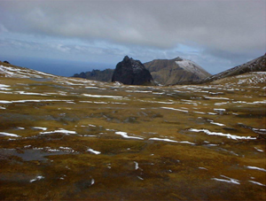
| View from Edinburgh Peak | |
| Waters | South Atlantic |
| Archipelago | Tristan da Cunha |
| Geographical location | 40 ° 19 ′ S , 9 ° 57 ′ W |
| length | 13.9 km |
| width | 8 kilometers |
| surface | 65 km² |
| Highest elevation | Edinburgh Peak 910 m |
| Residents | approx. 6 (ward staff) <1 inhabitant / km² |
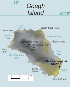
| Map of Gough Island | |
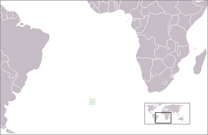
Gough [ gɔf- ] (also Portuguese Gonçalo Álvares ) is an approximately 900 m high volcanic island in the Atlantic Ocean , which belongs to the Tristan da Cunha archipelago . It is located about 400 kilometers southeast of the main island Tristan da Cunha and belongs to the British overseas territory of St. Helena, Ascension and Tristan da Cunha , whose main town Jamestown on the island of St. Helena is around 2700 kilometers away. The island belongs, along with the 2,004 added Island Inaccessible since 1995 on the World Heritage of UNESCO .
The island is located about 2600 km from Cape Town (South Africa) and about 3550 km from the South American mainland (Cabo de São Tomé).
geography
The island is 65 square kilometers, 13.9 kilometers long and up to 8 kilometers wide. Its highest point is Edinburgh Peak with a height of 910 m . Due to its location in the so-called Roaring Forties , there is a strong westerly wind almost all year round; the annual mean precipitation reaches 3397 millimeters and the air temperature averages 11.9 ° C.
discovery
The island was discovered in the early 16th century, possibly 1505 or 1506, by the Portuguese navigator Gonçalo Álvares , but its position was not initially determined exactly. The island, then called Diego Alvarez , was first set foot in 1675 by the English merchant Anthony de la Roché (see de la Roché's landing on Gough Island ), after he was knocked off his route by a storm and discovered South Georgia . The exact position of the island was not determined until 1731, when it was rediscovered by the British captain Charles Gough and then named after him.
Protection status
The first stage of its protection began in 1976 as a nature reserve . The British authorities previously arranged the Tristan da Cunha Conservation Ordinance of 1976 , which also included Gough Island. In 1985 the second step followed, with which the island was raised to the status of IUCN Ia Strict Nature Reserve , which allowed scientific research and otherwise largely cordoned off the area. In 1995 it was classified as a World Heritage Site .
Wildlife
The island is home to two endemic species of birds: the gough moorhen ( Gallinula comeri ) and the gough bunting ( Rowettia goughensis ). The house mouse ( Mus musculus ) was introduced by whalers in the 19th century. Due to their predatory behavior, they are now threatening the continued existence of native bird species. A 13-month campaign to eradicate the mice was therefore planned for 2017/2018. 32 of the 52 species of seabirds breed on the island. It is home to 48% of the world's northern rockhopper penguin ( Eudyptes chrysocome moseleyi ) population . Also known is the colony of the sub-Antarctic fur seals ( Arctocephalus tropicali ), in which three quarters of the worldwide population of this species live.
Early work and the research station
The public interest in the island arose from the nautical need to obtain weather data in the South Atlantic. This affected active seafarers in this region and the government of the South African Union . First, an attempt was made to determine the necessary values on Tristan da Cunha . However, this island proved insufficiently suitable for this purpose. In 1947, the then South African government commissioned the geophysicist and oceanographer Athelstan Frederick Spilhaus to look for alternatives. As a result of his work in this regard, he recommended the establishment of a weather station on Gough Island. Its construction was planned around 1950, but difficulties arose in recruiting staff. So one still had to make do with weather data from ships coming from South America and their synoptic forecast for the sea routes south of the Cape of Good Hope . From December 1953, a fishing company from Cape Town began operating in the sea area around the island. With the help of the deep-sea fishing vessel Voorbok , the calculated weather data could be checked on site. According to the results and assessments obtained, the island turned out to be a suitable location for the hoped-for weather observation station.
The systematic exploration of the island's ecosystem began between 1955 and 1956. During this period, the young geodesist John Bryan Heaney , who was absent due to illness at the beginning, led the privately organized six-month research trip known as the Gough Island Scientific Survey ( GISS ). In the process, previously unknown plants and birds were discovered. Martin Wyatt Holdgate , then chief biologist of the British Antarctic Survey , published the results of this trip in his 1958 work Mountains in the sea: The story of the Gough Island expedition in London . Heaney, who later worked in the oil industry, also did the first exact mapping of the island. This 1: 40,000 scale topographic map was published in The Geographical Journal of the Royal Geographical Society in 1957 . His expedition ended with a financial surplus and this formed the basis for further exploration. However, the results of this research were far more important, as they laid the earliest foundation stone for the later protected area on the island.
On the remote and lonely island, which is about 2600 km from Cape Town , South Africa has been operating a weather station with six to eight people continuously manned since 1956 ( 40 ° 20 ′ 57.7 ″ S , 9 ° 52 ′ 49.3 ″ W ) . The earliest location was at a point called The Glen , which was at the exit of a steep gorge on the coast to Quest Bay . In 1963 the station was relocated to a more southern and flatter region of the island. Hourly meteorological measurements are taken from there. The area of the station was leased by South Africa from the United Kingdom and is regionally administratively subordinate to the administration of Cape Town. The employees working there belong to the South African National Antarctic Program (SANAP).
Other Information
From August to September 1958, the USA tested the possibility of creating artificial radiation belts by means of atom bomb explosions at high altitudes (200 to 540 km) near the island with the Argus experiment . Such radiation belts are of military interest because they can impair radar and radio transmission, damage electronic components such as the detonation mechanisms of warheads, and endanger the health of spacecraft crews flying through. Three tests were carried out, including one from the USS Norton Sound .
In 2011 the island was used as a regatta stamp for the Barcelona World Race , which the participating boats had to circumnavigate on their way from Europe to the Cape of Good Hope (South Africa).
See also
Web links
- Entry on the UNESCO World Heritage Center website ( English and French ).
- Gough Island in the Global Volcanism Program of the Smithsonian Institution (English).
- Gough Island on The South Atlantic & Subantarctic Islands ( Memento July 29, 2010 in the Internet Archive ).
- Markus Kappeler: Gough moorhen - Gallinula comeri, Gough bunting - Rowettia goughensis. In: Markus Kappeler Zoologist - Text Collection .
- Gough Island. Description of the island and research station with images. South African National Antarctic Program (SANAP) (English).
Individual evidence
- ^ Gough Island. In: The Tristan da Cunha website. Tristan da Cunha Government and Tristan da Cunha Association, accessed April 10, 2017 .
- ↑ a b Lîle [sic!] Désolée on the Barcelona World Race website ( memento of January 25, 2011 in the Internet Archive ), accessed on December 5, 2016 (in French).
- ↑ a b Christine Hänel: Gough Island 500 years after its discovery: a bibliography of scientific and popular literature 1505 to 2005 . With extensive bibliography on Gough Island. In: South African Journal of Science . tape 104 , no. 9-10 , October 2008, ISSN 0038-2353 , p. 329-332 ( online in Scientific Electronic Library Online (SciELO) South Africa, accessed December 5, 2016).
- ↑ Dagny Lüdemann: Isle of Gough: Mouse eats albatross - On the Isle of Gough in the southern Atlantic, predatory rodents hunt rare sea birds. In: Der Tagesspiegel . May 22, 2008, accessed December 5, 2016.
- ^ Tristan da Cunha Programs. In: The RSPB: Conservation projects. Royal Society for the Protection of Birds , accessed December 5, 2016 .
- ↑ Daniel Lingenhöhl: Invasive species: Monster mice are at the collar. In: Spektrum.de . September 15, 2017. Retrieved September 15, 2017.
- ↑ Important Bird Areas factsheet: Gough Island. In: BirdLife Data Zone. BirdLife International , accessed December 5, 2016 .
- ^ Obituary: John Heaney Of The South Georgia Surveys. In: South Georgia Newsletter, November 2010. Government of South Georgia & the South Sandwich Islands, November 2010, accessed December 5, 2016 .
- ^ Gough Island Scientific Survey, 1955-56. In: Scott Polar Research Institute - Online resources. Department of Geography, University of Cambridge , accessed December 5, 2016 .
- ^ Martin Holdgate: Obituaries: John Bryan Heaney . Obituary. In: Polar Record . tape 48 , no. 2 . Cambridge University Press, April 2012, ISSN 0032-2474 , pp. 207–208 , doi : 10.1017 / S0032247411000015 (English).
- ^ Martin Holdgate: Obituary: John Bryan Heaney, 1931-2010 . In: The Geographical Journal . tape 177 , no. 1 . Royal Geographical Society , February 17, 2011, ISSN 0016-7398 , p. 94–95 , doi : 10.1111 / j.1475-4959.2011.00398.x (English, free article preview on deepdyve.com ).
- ↑ Bibliographical information on the map: Topographical map of Gough Island (color). Surveyed by JB Heaney, assisted by MW Holdgate of the Gough Island Scientific Survey, November 1955 to May 1956. Published by the Royal Geographical Society, London.


