
Skjálfandafljót
| Skjálfandafljót | ||
 Goðafoss |
||
| Data | ||
| location | Iceland | |
| River system | Skjálfandafljót | |
| source | Bárðarbunga / Vatnajökull or Vonarskarð / Tungnafellsjökull | |
| muzzle |
Skjálfandi Bay ( Arctic Ocean ) Coordinates: 65 ° 59 ′ 0 ″ N , 17 ° 38 ′ 0 ″ W 65 ° 59 ′ 0 ″ N , 17 ° 38 ′ 0 ″ W |
|
| Mouth height |
0 m
|
|
| length | 178 km | |
| Catchment area | 3860 km² including 140 km² on glaciers |
|
| Drain |
NNQ MNQ HHQ |
30–70 (winter) 70–200 (summer) 1000 m³ / s
|
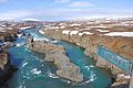
| Waterfalls: Aldeyjarfoss , Goðafoss | ||
 The mouth of the Skjálfandafljót |
||
The Skjálfandafljót river is located in the north of Iceland and has a length of about 178 km.
Surname
The name means trembling current , which has to do with the bay Skjálfandi (= the trembling) and with the frequency of earthquakes in this area at the Tjörnes rupture zone , an active transfer zone that connects the rift and volcanic zone of Iceland with the northern part of the Mid-Atlantic Ridge , the Kolbeinsey ridge , connects.
course
It is a very important river, the fourth longest in Iceland.
It rises on the northwest edge of the Vatnajökull glacier in the Icelandic highlands . It also takes up source rivers from the high temperature area at Vonarskarð (Lage) belonging to Tungnafellsjökull (Lage) . It then flows roughly parallel to the Sprengisandur highland route north into the Bárðardalur valley and finally flows into the Skjálfandi bay.
On the way the river pours over numerous waterfalls, the most famous of which are Aldeyjarfoss and Goðafoss .
In the lower reaches just before the mouth of the Skjálfandi bay between the Köldukinn mountain range on the Flateyjarskagi peninsula and the Aðaldalur valley, there is an island in the river called Þingey . The whole Þingeyjarsýsla district is named after this.
history
The first settlers of the area was under the Conquest book Bárður Heyjangurs-Bjarnarson , surnamed Gnupa-Bárður wore. He is said to have pulled his ship up the river from the sea.
The valley Bárðardalur and the volcano Bárðarbunga were named after this settler .
Flora and fauna
In 2009, flora and fauna in the upper reaches of the river were examined separately because of a possible planned construction of two hydroelectric power stations. It turns out that much of the area is bare and desert, but there is also some moorland and areas overgrown with bushes, shrubs and small trees and mosses.
The bird life was particularly striking, as numerous short-billed geese , golden plovers , dunlins , ringed ducks and falcons breed here .
See also
Web links
- photo
- Náttúrúfræðistofnun: Vistgerðir á Miðhálendi Íslands - Skjálfandafljót (studies of flora and fauna in the upper valley of Skjálfandafljót) (PDF, Icelandic with maps; 8.3 MB)
- Association of fishing rights owners: salmon and trout fishing in the lower reaches of the Skjálfandafljót (English)
Individual evidence
- ↑ a b c d e f g h Íslandshandbókin. Náttúra, saga og sérkenni. 1. bindi. Edited by T. Einarsson, H. Magnússon. Örn og Örlygur, Reykjavík 1989, p. 503f.
- ^ HU Schmid: Dictionary Icelandic - German. Buske, Hamburg, 2001, 221 and 68
- ↑ cf. Also: Ísland Vegaatlas. Ed. Ferðakort, Reykjavík 2006, 18 and 19
- ↑ a b Náttúrúfræðistofnun: Vistgerðir á Miðhálendi Íslands - Skjálfandafljót , NÍ Skýrsla 09009, 2009, p.5; accessed: September 14, 2012 ( page no longer available , search in web archives ) Info: The link was automatically marked as defective. Please check the link according to the instructions and then remove this notice. (PDF; 8.3 MB)

At Aldeyjarfoss

At Goðafoss
The Skjálfandafljót below the Goðafoss


