Raufarhöfn
| Raufarhöfn | ||
|---|---|---|
|
|
||
| Coordinates | 66 ° 27 ′ N , 15 ° 57 ′ W | |
| Basic data | ||
| Country | Iceland | |
| Norðurland eystra | ||
| ISO 3166-2 | IS-6 | |
| local community | Norðurþing | |
| Residents | 168 (January 1, 2019) | |
|
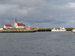
Raufarhöfn harbor
|
||
The small town of Raufarhöfn [ ˈrøyvarhœpn̥ ] is located as part of the Norðurþing municipality on the Melrakkaslétta peninsula in northeast Iceland .
location
From Raufarhöfn it is about 15 km to the northernmost point on the mainland of the island, Hraunhafnartangi (German: "headland of the lava port"). The Arctic Circle is about 2 km away. The white lighthouse Hraunhafnartangaviti dates from 1945.
The distance to the capital Reykjavík is 634 km.
climate
The climate of Raufarhöfn is arctic ( effective climate classification : ET). The highest temperature ever recorded was 24.7 ° C in August and the coldest ever recorded temperature was -24.6 ° C in March. Due to the exposed coastal location and the maritime influence in combination with arctic air masses, both the course of the day and the differences between the seasons (only about 10 ° C between July and January) are very small. Furthermore, due to the location immediately south of the Arctic Circle, there is no sunshine in December and even in July, despite the polar day, the sun only shines on average for 3.8 hours per day, which in turn is due to the inconsistent and often cloudy weather.
| Raufarhöfn | ||||||||||||||||||||||||||||||||||||||||||||||||
|---|---|---|---|---|---|---|---|---|---|---|---|---|---|---|---|---|---|---|---|---|---|---|---|---|---|---|---|---|---|---|---|---|---|---|---|---|---|---|---|---|---|---|---|---|---|---|---|---|
| Climate diagram | ||||||||||||||||||||||||||||||||||||||||||||||||
| ||||||||||||||||||||||||||||||||||||||||||||||||
|
Average monthly temperatures and precipitation for Raufarhöfn
Source: Icelandic Meteorological Office
|
||||||||||||||||||||||||||||||||||||||||||||||||||||||||||||||||||||||||||||||||||||||||||||||||||||||||||||||||||||||||||||||||||||||||||||||||||||||
Surname
The name comes from a narrow sound called Rauf (Eng. "Gap", "crack"), which is located between a small island and a hilly headland, Hólmur and Höfði.
history
Raufarhöfn received market rights in 1836. At that time, a Danish merchant built a large building called Búðin in Raufarhöfn , which burned down completely in 1956, but was soon replaced.
However, the place is already mentioned in the Icelandic Sagas as a trading place and it also seems to have been known to the merchants of the Hanseatic League .
Before 1830, there were only a few smaller farms in the area. After a smallpox epidemic at the beginning of the 18th century, the area was even completely deserted.
In the 1950s, Raufarhöfn was a very busy place, mainly due to the large and nearby herring fishing grounds . On the initiative of merchants and fishing entrepreneurs, the port had already been expanded around 1900 so that large sailing ships could dock there. Later, the port was expanded to accommodate the herring boats and to facilitate export. Processing plants emerged, initially under Norwegian management until 1924, when the Icelandic state bought them. Until the end of the 1960s, Raufarhöfn was one of the most important export ports for herring in Iceland.
When the herring ceased to exist at the end of the 1960s, the area suffered economic decline, which, in addition to the isolated location, was certainly a decisive factor in the increasing rural exodus. On January 1, 2019, Raufarhöfn had 168 inhabitants, but in 1988 it was 401.
In the meantime, attempts are being made to focus more on tourism with the expansion of the hotel and the construction of a very original Arctic monument ( Heimskautsgerði ). The proximity to the Arctic Circle , which is approx. 17 km north of the town and at the same time 2 km off the coast, is useful here .
The church of Raufarhöfn
It was designed by none other than Iceland's national architect Guðjón Samúelsson and consecrated in 1928. The church underwent a thorough renovation. a. 1979. The main altarpiece and pulpit come from Ásmundarstaðir .
Economy and Services
Raufarhöfn is a service center for the residents of the area, who mostly still live from agriculture and fishing.
The place has a bank, a gas station, a shop with a café and a hotel, a community hall with a restaurant, as well as a kindergarten and elementary school. There is also medical care in a health center (isl. Heilsugæsla ).
There is also a gym with a public swimming pool.
Campsites and marked hiking trails are also used for tourism.
Town twinning
Within Iceland there is a town twinning with Hólmavík .
See also
Web links
- Web presence of the former municipal administration of Raufarhöfn (Icelandic)
- Pictures from the Arctic Monument (isl. Heimskautsgerðið ) in Raufarhöfn
Individual evidence
- ^ HU Schmid: Dictionary Icelandic-German. Buske, Hamburg 2001, p. 191.
- ↑ a b T. Einarsson, H. Magnússon (eds.): Íslandshandbókin. Náttúra, saga og sérkenni. 2. bindi. Örn og Örlygur, Reykjavík 1989, p. 535.
- ↑ a b T. Einarsson, H. Magnússon (eds.): Íslandshandbókin. Náttúra, saga og sérkenni. 2. bindi. Örn og Örlygur, Reykjavík 1989, pp. 534f.
- ↑ a b c d Archived copy ( memento of the original from April 17, 2013 in the Internet Archive ) Info: The archive link has been inserted automatically and has not yet been checked. Please check the original and archive link according to the instructions and then remove this notice. Off. Website Raufarhöfn (Icelandic); Accessed July 25, 2011
- ↑ T. Einarsson, H. Magnússon (Eds.): Íslandshandbókin. Náttúra, saga og sérkenni. 2. bindi. Örn og Örlygur, Reykjavík 1989, p. 534.


