Þingeyjarsveit
| Basic data | |
|---|---|
| State : |
|
| Region: | Norðurland eystra |
| Constituency : | Norðausturkjördæmi |
| Sýsla : | Suður-Þingeyjarsýsla |
| Population: | 894 (January 1, 2019) |
| Surface: | 5988 km² |
| Population density: | 0.15 inhabitants / km² |
| Post Code: | 650 (Laugar) 645 (Fosshóll) |
| politics | |
| Community number | 6612 |
| Mayor: | Jóhann Guðni Reynisson |
| Contact | |
| Address of the municipal administration: | Kjarna 650 Laugum |
| Website: | www.thingeyjarsveit.is |
| map | |

Coordinates: 65 ° 43 ′ N , 17 ° 22 ′ W |
|
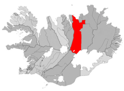
Þingeyjarsveit (in romanization Thingeyjarsveit ) is an Icelandic municipality and is located in the region of Norðurland eystra .
On January 1, 2019, the community had 894 inhabitants, 115 of whom lived in Laugar .
geography
The elongated, water-rich municipal area on both sides of the Skjálfandafljót river stretches from the coast of Skjálfandi Bay with the island of Flatey in the north to the Tungnafellsjökull glacier in the highlands in the south. The Goðafoss waterfall and the Vaglaskógur birch forest , which runs along the Fnjóská river, are located in the municipality .
South of Skjálfandi Bay is the Aðaldalshraun area and the Aðaldalur and Laxárdalur of the Laxá River . The main town of the municipality, Laugar , lies a little further west, south of Vestmannsvatn . West of Laugar is Goðafoss , further west of Ljósavatn , southeast of Másvatn and further south of Kálfborgarárvatn . The area south of Laugar east of Skjálfandafljóts is called Fljótsheiði . The lakes Svartárvatn and the somewhat larger Íshólsvatn are located further south . In the southwest of the municipality are the lakes Vegamótavatn and Fjórðungsvatn . The Vatnajökull glacier is located in the southeast of the municipality . The shield volcano Trölladyngja lies on the municipality boundary with Skútustaðahreppur to the east in the area of the large lava field Ódáðahraun .
South of Þingeyjarsveit are the municipalities Skaftárhreppur and Ásahreppur , to the west Eyjafjarðarsveit , in the northwest Svalbarðsstrandarhreppur and Grýtubakkahreppur , in the northeast the municipality Norðurþing and in the east Skútustaðahreppur .
history
The municipality Þingeyjarsveit was formed on November 15, 2001 by the merger of the rural communities Háls ( Hálshreppur ), Ljósavatn ( Ljósavatnshreppur ), Bárðdælahreppur and Reykdælahreppur.
On April 26, 2008, Aðaldalur ( Aðaldælahreppur , municipality number 6609) was incorporated into Þingeyjarsveit. Aðaldalur had rejected an incorporation into Húsavík in a referendum on October 8, 2005.
Attractions
The Icelandic turf house Grenjaðarstaður is since 1958 opened museum.
Population development
Like most areas of Iceland in the meantime, except for the southwest around the capital Reykjavík, the area of Þingeyjarsveit was affected by severe rural exodus. From 1997 to 2005 the population decline was 16%. In 2006 there was an increase in population which was reversed in 2007.
| Year * | Residents of Þingeyjarsveits | Resident of Aðaldalur |
|---|---|---|
| 1997 | 821 (territory from 2001) | - |
| 2003 | 716 | 280 |
| 2004 | 698 | 265 |
| 2005 | 686 | 256 |
| 2006 | 699 | 257 |
| 2007 | 681 | 261 |
| 2008 | 945 (with Aðaldalur) | (266) |
* on December 1st
Sons and daughters
- Múli: Jón Magnússon (1859–1926), Icelandic Prime Minister
- Sílalækur: Guðmundur Friðjónsson (1869–1944), Icelandic writer

