Kópasker
| Kópasker | ||
|---|---|---|
|
|
||
| Coordinates | 66 ° 18 ′ N , 16 ° 27 ′ W | |
| Basic data | ||
| Country | Iceland | |
| Norðurland eystra | ||
| ISO 3166-2 | IS-6 | |
| local community | Norðurþing | |
| Residents | 121 (January 1, 2019) | |
|
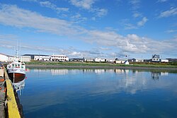
Port of Kópasker
|
||
Kópasker ([ ˈkʰouːpaˌscɛˑr ], dt. " Archipelago of the seal boy") is a place in the municipality of Norðurþing in northeast Iceland.
Economically, Kópasker is shaped by agriculture and fishing. On January 1, 2011 the place had 121 inhabitants.
The locality is supplied with thermal water from the Skógalón borehole.
geography
Kópasker is located on Öxarfjörður in the west of the Melrakkaslétta peninsula and thus in a geologically active area where the northeastern volcanic and rift zone intersects with a fracture zone. Therefore, the area is sometimes - most recently in 1976 - shaken by more violent earthquakes.
In the Röndin district you can find layers of sediment with mussels from the Ice Age.
About 20 kilometers north of Kópasker is the partially eroded volcano Rauðinúpur ( Eng . "Red Mountain Peak ").
history
In 1880 an international trading post was established here. A village was only formed on the site from around 1910 when the Kaupfélag Norður-Þingeyinga trading company established department stores.
The Kópaskersviti lighthouse to the north of the village was built in 1945.
On January 13, 1976, an earthquake measuring 6.2 on the Richter scale , the epicenter of which was about 12 km southwest in Öxarfjörður, caused considerable damage in the place, for example to the water supply and the port fortifications.
For a long time the port was not particularly well developed, this only happened after 1989. However, the fishing and fish processing were the main sources of income for the place in the last 50 years.
The place also serves as a service center for the farmers in the area with a health center, shops and various school facilities (kindergarten and Grunnskóli ). The offers for tourists with various guest houses and restaurants are still being expanded.
As in many places outside the capital area, you can feel the rural exodus here too, the place still had 157 inhabitants in 1988.
Until 2006, Kópasker belonged as the main town to the rural community Öxarfjörður (Öxarfjarðarhreppur), which was incorporated into Norðurþing.
Culture and sights
The local history museum, designed by Guðjón Samúelsson , is located on the Snartastaðir farm near the district library and east of Lake Kotatjörn. It shows tools and many other everyday objects.
traffic
Kópasker is on Sléttuvegur, road 870. This was the original Norðausturvegur that circled the peninsula. The place is 579 kilometers from the capital Reykjavík and 99 kilometers from Húsavík .
The commercial port is suitable for ocean-going ships.
See also
literature
- Jens Willhardt, Christine Sadler: Iceland. 3rd updated and revised edition. Michael Müller, Erlangen 2003, ISBN 3-89953-115-9 , p. 436f.
Web links
Individual evidence
- ↑ National Statistical Office of Iceland Hagstofa http://hagstofa.is/?PageID=625&src=/temp/Dialog/varval.asp?ma=MAN03106%26ti=Mannfj%F6ldi+eftir+bygg%F0akj%F6rnum%2C+kyni+og + aldri + 1% 2E + jan% FAar + 1998% 2D2011 +++++% 26path = .. / Database / mannfjoldi / Byggdakjarnar /% 26lang = 3% 26units = Fj% F6ldi Accessed: April 10, 2011
- ↑ a b c travel guide. The north-east. ( Memento of the original from July 6, 2008 in the Internet Archive ) Info: The archive link was automatically inserted and not yet checked. Please check the original and archive link according to the instructions and then remove this notice.
- ↑ a b Ari Trausti Guðmundsson: Living Earth. Facets of the geology of Iceland. Reykjavík, Mál og Menning, 2007, p. 139
- ↑ a b c Íslandshandbókin. 1. bindi. Ed. Th. Einarsson ea 1989, pp. 530f.
- ↑ Vegahandbókin. Ed. Landmælingar Íslands. 2006, p. 376


