Eyjafjordur
| Eyjafjordur | ||
|---|---|---|
|
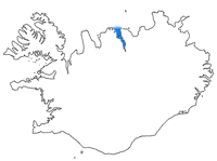
Eyjafjörður, location marked in blue |
||
| Waters | Greenland Sea | |
| Land mass | Iceland | |
| Geographical location | 65 ° 52 ′ N , 18 ° 8 ′ W | |
|
|
||
| width | 25 km | |
| depth | 60 km | |
| Tributaries | Eyjafjarðará | |
|
Eyjafjörður as seen from Dalvík |
||
The Eyjafjörður (also: Eyjarfjörður ) is a 60 kilometers long and up to 24 km wide fjord in the northeast of Iceland in the east of the peninsula Tröllaskagi . It is the longest fjord in Iceland.
Position and shape
It is bounded in the west by Tröllaskagi and in the east by the mountainous Flateyjarskagi peninsula . Here, too, the mountains rise up to over 1000 m, e.g. B. Kaldbakur (1167 m).
The fjord is quite deep, but there are two shoals that large ships, such as the numerous cruise ships, have to avoid: Hörgárgrunn and Laufásgrunn in front of the Laufás rectory museum .
Two smaller fjords branch off from the outer fjord to the west: Héðinsfjörður and Ólafsfjörður .
At the southern end of the fjord is the town of Akureyri , on the west bank the fishing villages Dalvík and Ólafsfjörður, on the east bank the open-air museum Laufás and the town Grenivík .
Hrísey Island and name of the fjord
In the fjord itself is the island of Hrísey . It is very likely that this gave its name to the name "Inselfjord" (the translation of Eyjafjörður).
The white smokers in Eyjafjörður
In 1997 hot springs were discovered about 1800 m from the Víkurskarð pass in Eyjafjörður. These have formed three pillars that are up to 45 m high.
The geothermal springs are located in basaltic lavas that are 6 to 12 million years old. They appear to be associated with one or two fracture zones towards NE and NW, but where no hot springs are known.
The smokers were examined more closely. It turned out that the water flowing out of them is 72 ° hot. The pillars are made of smectite , a clay mineral that forms when SiO 2 -rich liquid meets cold, magnesium-containing water. They also examined the bacteria on the smokers.
They have been under nature protection since 2001 and have become a popular destination for diving trips.
In addition to this group of smokers, other groups of smokers have now been found in northern Eyjafjörður, but they have not yet been investigated.
Eyjafjörður valley
As is customary in Iceland, the valley connected to it bears the same name as the fjord or Eyjafjarðardalur . It extends about 60 km south into the country.
See also
Web links
To the smokers in Eyjafjörður
- To the smokers, Geoscience, engl.
- VT Marteinsson, JK Kristjánsson, H. Kristmannsdóttir, M. Dahlkvist, K. Saemundsson, M. Hannington, SK Pétursdóttir, A. Geptner, P. Stoffers: Discovery and description of giant submarine smectite cones on the seafloor in Eyjafjordur, northern Iceland, and a novel thermal microbial habitat. In: Applied and environmental microbiology. Volume 67, number 2, February 2001, pp. 827-833, doi : 10.1128 / AEM.67.2.827-833.2001 , PMID 11157250 , PMC 92654 (free full text).
- For sampling, Morgunblaðið, July 1998, isl.
- Law on the Conservation of Smokers, isl.
- For cleaning smokers, RÚV, 2009, isl.
Individual evidence
- ↑ Nadja Podbregar: Iceland's longest fjord. In: Wissenschaft.de. May 14, 2020, accessed May 16, 2020 .
- ↑ a b V. T. Marteinsson, JK Kristjánsson, H. Kristmannsdóttir, M. Dahlkvist, K. Saemundsson, M. Hannington, SK Pétursdóttir, A. Geptner, P. Stoffers: Discovery and description of giant submarine smectite cones on the seafloor in Eyjafjordur, northern Iceland, and a novel thermal microbial habitat. In: Applied and environmental microbiology. Volume 67, number 2, February 2001, pp. 827-833, doi : 10.1128 / AEM.67.2.827-833.2001 , PMID 11157250 , PMC 92654 (free full text).
- ↑ Archive link ( Memento of the original dated November 12, 2007 in the Internet Archive ) Info: The archive link was inserted automatically and has not yet been checked. Please check the original and archive link according to the instructions and then remove this notice. , accessed: February 26, 2010
- ↑ Íslandshandbókin, 1st bindi. Reykjavík, 1989, p. 429


